$3.5 Billion Korean Positioning Service on Track for 2027 Launch
New Satellite Navigation Service Could Create 60,000 Jobs
JAVAD offers Triumph-LS Plus and Triumph 3 Latest-Generation Receiver. Javad GNSS is looking for new talent to join their team!
While South Korea’s Korean Positioning System (KPS) has been planned for years, recent press and government announcements signal that the local satellite navigation constellation will soon be a reality.
The KPS project, estimated to cost anywhere from $3.1 to $3.5 billion, proposes to launch its first navigation satellite in 2027. By 2035, there may be as many as seven or eight satellites in orbit.
The KPS is not designed to be a rival to GPS, but will be a compatible and supplemental network. In fact, the U.S. and South Korea officials signed a cooperation agreement June 3 to develop the network.
The proposed satellite service hasn’t made headlines in many U.S. publications, but the constellation is forging ahead—with or without publicity. In fact, if successful, there are estimates that the service could create as many as 60,000 jobs in South Korea and elsewhere.
In an interview with The Korea Herald, Jung Byung-gi, a vice president of LIG Nex1, said the aerospace defense contractor would lead the project, scheduled to roll out next year. LIG Nex1 developed Korea’s first auto GPS navigation system in April 1997, according to the article.
Once launched, South Korea will be the seventh nation to have its own satellite navigation system.
New Apple 3D Maps Rolled Out in Four Cities
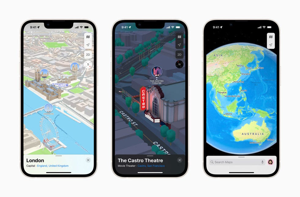
Enhanced 3D Apple Maps, in the new iOS 15 operating system, are now available in London, Los Angeles, New York and San Francisco. The new enhancements include a 3D driving view with road details that help users identify turn lanes, medians, crosswalks, and sidewalks, the company said.
The enhanced 3D allows users to see custom-designed landmarks, new road labels and elevation details, the company said. Apple Maps also includes a new nighttime mode with a “moonlit glow” that activates at dusk.
Other cities to get access to the 3D maps later this year include Philadelphia, San Diego, and Washington. Next year, Montreal, Toronto and Vancouver will have 3D map availability.
Some new navigation features include better marking of turn lanes, medians, crosswalks, and sidewalks, the company said. The new navigation and route planning, which provides the estimated time of arrival for future departures based on expected traffic, will be available through CarPlay later this year, the company said.
With iOS 15, Apple Maps has step-by-step walking directions that includes augmented reality, the company said. For transit, users now can see nearby stations and departure times on the top of the screen in Maps, the company said.
Xona Space Systems Receives $8 Million Funding for LEO PNT Satellite Mission
San Mateo, Calif.-based Xona Space Systems has raised $8 million for its proposed independent LEO satellite navigation services. The new funding round, led by Seraphim Space Investment Trust [SSIT] and MaC Venture Capital, will support Xona’s first orbital mission, scheduled for mid-2022, the company said.
The mission will demonstrate Xona’s Pulsar LEO PNT service, which is the first independent satellite navigation and timing system designed to take advantage of small satellites. The company says that Pulsar also has 10 times better accuracy than legacy GNSS constellation. In addition, Xona says its satellite provide 100 times better interference mitigation than the legacy GNSS.
Other Xona investors include Toyota Ventures, u-blox co-founder Daniel Ammann and Ryan Johnson, former BlackBridge CEO and operator of the Rapideye constellation. Follow-on investors also include 1517 Fund and Stellar Solutions, the company said.
“The time is ripe for the next generation of satellite navigation systems with lower-cost private launch services,” said Jim Adler, Founding Managing Director of Toyota Ventures, in a statement.
Xona, which is expanding their laboratories to support Pulsar’s development, successfully tested their navigation system during a ground-based demo earlier this year. Employees include industry veterans from NASA, Lockheed Martin [LMT], Maxar, L3 Harris, Blue Origin and SpaceX.
In August, Spirent Federal Systems announced a collaboration with Xona to develop simulation and test capabilities for signals produced by smallsats.
Contact: Jennifer Thompson, for Xona, (503) 724-4076, jen@eighthrule.com.

Other Location News:
News tip? Send them to kdennehy@driverlessreport.com. Go to www.locationbusinessnews.comfor more news and an archive of stories.
🛰 SpaceX Satellite Signals Used Like GPS to Pinpoint Location on Earth. “The Starlink satellites, sent into orbit by Elon Musk’s SpaceX, are designed to provide broadband internet connections in remote locations around the world. The researchers used signals from six Starlink satellites to pinpoint a location on Earth within 8 meters of accuracy.”
😮 $10 Billion for Next-Generation 911 in Budget Package Looks Promising, Experts Say. That’s a big chunk of change…but how much goes to location technology purchases?
😒 Spectrum Screen Unlikely To Happen Anytime Soon, Says Former FCC Chief “Before he joined the FCC, [Tom] Wheeler served on the Technological Advisory Council of the commission, which conducted a lengthy investigation related to Ligado. Through all of that study, nothing emerged to indicate it would pose harmful interference with GPS, according to Wheeler. Yet to this day, the GPS community is still raising concerns about Ligado.”
🚗 GM Invests $300 Million in Chinese Autonomous Driving Startup Momenta. “Momenta is among the few companies that hold a permit for gathering high-definition maps in China, a key tool in autonomous driving technologies.”
🚕 Beijing Taxi Takes on Didi With Alibaba’s Autonavi Mapping Service. “The service called Beijing Taxi is being offered through AutoNavi, the digital maps service provider owned by e-commerce giant Alibaba.”
😫 Unagi's $2,440 smart scooter includes turn-by-turn directions and GPS tracking. Sign of the Apocalypse Part II, a $2,440 scooter…
😲 A Cyclist Has ‘Drawn’ Nirvana’s Nevermind Cover Using GPS Tracking. I am not sure if this is a “get a life” thing…or cool.
Advertisement
Have you ever been reluctant to reveal your personal email address online or in person?
The answer is almost universally YES! So, if you happen to be one of those who thinks twice about these matters, ManyMe might be the answer to your worries.

Location Industry Briefs
Send your news to kdennehy@driverlessreport.com. Go to www.locationbusinessnews.comfor more news and an archive of stories.
Totum Conducts Indoor Location Testing, Says 2 Million Devices Ordered
Totum has conducted successful indoor operation of their direct-to-satellite IoT connectivity solution, the company said. The demonstration showcased bidirectional communication between a fully integrated system-on-a-chip (SoC) and Totum's low-earth orbit (LEO) satellite.
The Totum product provides connectivity and position fixes for low-powered IoT location tracking and monitoring systems, which require battery life of up to 10 years, the company said. The company said OEM, solution provider and resellers have placed advance orders for 2 million devices with the service.
Contact: Totum, www.totum.global.
Broadcom Rolls Out Third-Generation GNSS Receiver
Broadcom’s BCM4778 is the company’s third-generation dual-frequency L1L5 GNSS receiver. It features advanced multipath mitigation, L5 acquisition capability, in-band and out-of-band filtering, integrated PMU with direct connection to battery and jamming protection, the company said.
The BCM4778, which features Grid Tracking technology for enhanced urban accuracy, reduces power consumption by 5 times compared to the previous generation, the company said. The company is targeting mobile and wearable markets for the receiver.
Contact: Broadcom, https://www.broadcom.com/products/wireless/gnss-gps-socs/bcm4778.
CalAmp Records Quarterly Earnings
CalAmp [CAMP] reported that revenue increased 6 percent to $79 million from the following year in second quarter of fiscal year 2022 ended Aug. 31. While telematics products were down 16 percent at $38 million because of supply chain shortages, software and subscription services increased to a record $41 million, the company said.
Trimble Rolls Out New GNSS Receiver for Catalyst Positioning Service
Trimble [TRMB] has launched its DA2 GNSS receiver for the Trimble Catalyst positioning service. The DA2, which is the second-generation receiver and antenna for the Catalyst service and available in 2021’s fourth quarter, includes the Trimble ProPoint GNSS engine, the company said.

ProPoint technology reduces convergence times and improves positioning accuracy when operating near trees and buildings, the company said. Trimble Catalyst is a subscription-based GNSS positioning service for location-enabled field applications.
Contact: Trimble, geospatial.trimble.com/catalyst.
u-blox Wins TIBCO Software Award
Thalwil, Switzerland-based u-blox [UBXN] has been awarded the 2021 ISV Partner of the Year award by TIBCO Software. The award, presented at the annual TIBCO Partner Excellence Awards, recognize partners that leverage TIBCO technology to develop, market, sell, and deliver industry-leading solutions while achieving the highest degree of customer success and satisfaction, the company said.
Contact: Natacha Seitz, u-blox, 41 76 436 0788, natacha.seitz@u-blox.com.
Advantage GPS Acquires Asset Tracking Technology
Advantage GPS has announced the acquisition of Michigan-based Asset Tracking Technology company. Asset Tracking Technology is a distributor of GPS tracking devices for finance companies, buy-here pay-here dealerships, fleet tracking and personal tracking devices, the company said. Advantage's technology delivers vehicle location and intelligence that monitors and assesses finance risks in real time, the company said. Financial details were not disclosed.
Contact: Advantage GPS, AdvantageGPS.com.
Garmin Launches Adventure Racing Sport Profile
Garmin International [GRMN] has launched its Adventure Racing sport profile that allows participants to track information and use their Enduro watch, making it the first GPS-enabled timepiece that is authorized. An Adventure Race is a multisport orienteering competition through some of the most rigorous environments on earth, Garmin said.
Enduro features advanced training features and key performance monitoring tools for peak performance, Garmin said. A full charge will provide an athlete up to 70 hours in GPS mode which is extended up to 80 hours with solar capabilities, the company said.
Contact: Natalie Miller, Garmin, (913) 397-8200, media.relations@garmin.com, garmin.com/newsroom.
Inpixon Secures Patent for Sensor Fusion to Determine Location
Inpixon [INPX] has received a Notice of Allowance from the U.S. Patent and Trademark Office allowing its patent application covering a multi-channel spatial positioning system. The company believes this patent affords it broad protection in sensor fusion, which can increase location determination accuracy.
The patent covers Inpixon's invention of combining multiple methods of positioning and overlaying each with its own confidence factor to achieve more accurate location determination than a single method, the company said. “Through these patented methods, we are able to activate data from the physical environment, wearables or signals from a person, and external data to deliver more complete and accurate results that leverage our map, video and augmented reality platforms,” said Adam Benson, Inpixon CTO, in a statement.
Contact: Inpixon, marketing@inpixon.com, inpixon.com.
2J Antennas Offers Smallest 5GNR, WiFi-6E and GNSS Antennas
2J Antennas has introduced its Stellar Series that focuses on sub 6 GHz, 5G NR, 4G LTE, 3G, 2G, WiFi-6E and GNSS technologies. The new series focuses on law enforcement, medical transportation, fire rescue, and other emergency markets.
The Stellar Series offers magnetic and adhesive mounting choices, making them ideal for temporary installations, the company said. For permanent installation, 2J Antennas also offers the screw mount option in their Roof Series.
Contact: Milos Gendiar, 2J Antennas, media@2j-antennas.com.
Mobilogix Introduces Trailer Tracking Device
Mobilogix has introduced its BAT-XL tracking device for trailer, container and equipment tracking. The unit uses low-power LTE CAT-M1/ NB-IoT technology with embedded Bluetooth.
BAT-XL features global deployment with a single hardware SKU, field replaceable battery, AWS IoT Core integration and remote device management through fusion IoT, the company said. BAT-XL can act as a standalone long-life tracker or as a Bluetooth Gateway solution for BTM250-series beacon sensors.
Contact: Greg Oppenheim, Mobilogix, (949) 365-6236, info@mobilogix.com.
People
Trimble Names Chief Platform Officer, CTO
Trimble [TRMB] has announced that Jennifer Lin has been appointed chief platform officer and Poppy Crum as chief technology officer. As chief platform officer, Lin will lead Trimble's platform strategy to develop and deliver connected industry workflows, the company said. Lin previously worked at Google where she served as vice president of product and user experience.
As chief technology officer, Crum will lead Trimble's technical vision and advance a culture of innovation, the company said. Crum joins Trimble from Dolby Laboratories, where she served as chief scientist, leading data-driven innovation in technology development and strategy.
Contact: Contact: Lea Ann McNabb, Trimble, (408) 481 7808, leaann_mcnabb@trimble.com, www.trimble.com.
Pozyx Names Board Chairman
Pozyx has appointed Frans Frielink as chairman of the board. Frielink has more than 30 years of experience in high-growth wireless technology organizations with NCR, AT&T Bell Labs, RF Micro Devices, BridgeCo and GreenPeak Technologies/Qorvo.
Contact: Elly Schietse, Pozyx, 32 479-761825, marketing@pozyx.io.
Jobs
Javad GNSS is looking for new talent to join their team! JAVAD GNSS.
Financial Communications Manager. TomTom.


