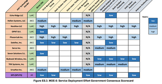
The U.S. Department of Transportation last month released its Complementary PNT and GPS Backup Technologies Demonstration Report that details technologies offering complementary service in the event of a GPS disruption.
The DoT’s Volpe Center, through a competitive acquisition process, selected 11 candidate technologies to demonstrate positioning or timing functions in the absence of GPS:
Two vendors demonstrated Low Earth Orbit satellite PNT technologies, one L-band, one S-band Two vendors demonstrated fiber-optic timing systems, both based on the White Rabbit Precision Time Protocol (PTP) technology.
One vendor demonstrated localized database map matching database, Inertial Measurement Unit (IMU), and ultra-wideband (UWB) technologies.
Six vendors demonstrated terrestrial RF PNT technologies across, Low-Frequency (LF), Medium-Frequency (MF), Ultra-High Frequency (UHF), and WiFi/802.11 spectrum.
GPS expert and consultant Logan Scott said that while the report was excellent, and provides good guidance on technologies that may provide solid GPS augmentation, he cites several that were not demonstrated, notably 4G and 5G NR. “Both of which have significant, and demonstrated, timing and positioning capabilities independent of GNSS. The market will play a major role in deciding what actually will be available,” he said.
In addition, Scott said the report’s section that ranks performance sensitive and cost-sensitive bases has received a lot of industry attention. “While I don’t disagree with the general assessments, there is a considerable hazard in applying them blindly to select a national strategy,” he said.
Scott also questioned the testing of a technology’s resiliency. “None of the technologies was tested in an adversarial environment, e.g. jamming, cyber-attack, etc. A truly resilient system is a system of systems and the measure of its resilience is performance under attack and that is mostly a function of how well the systems are integrated,” he said.
Scott said that some of the technology is already offered in the marketplace. “Some—Satelles [LEO Iridium]--are available now for a subscription price. Others, NextNav [928 MHz beacons], perform extremely well, but will require significant infrastructure investment as contrasted with UrsaNav [eLoran], which provides lesser positioning capabilities, but can be deployed fairly inexpensively. Ultimately, the choices will be made by the market, he said.”
The DoT’s Volpe Center, through a competitive acquisition process, selected 11 candidate technologies to demonstrate positioning or timing functions in the absence of GPS:
Two vendors demonstrated Low Earth Orbit satellite PNT technologies, one L-band, one S-band Two vendors demonstrated fiber-optic timing systems, both based on the White Rabbit Precision Time Protocol (PTP) technology.
One vendor demonstrated localized database map matching database, Inertial Measurement Unit (IMU), and ultra-wideband (UWB) technologies.
Six vendors demonstrated terrestrial RF PNT technologies across, Low-Frequency (LF), Medium-Frequency (MF), Ultra-High Frequency (UHF), and WiFi/802.11 spectrum.
NextNav’s TerraPoint terrestrial-based location product earned high ratings in the testing. TerraPoint works with a network of transmitters and altitude stations.
Ridar Systems Integrates HERE Location Technology for Two-Wheel Mobility Safety
Ridar Systems will integrate HERE location technology into the company’s cloud-based mobile safety product. The deal allows Ridar to better identify the location of two-wheelers to provide a more accurate position to drivers, the company said.
Using a smartphone, the company says that motorcycles, bicycles, scooters and other two-wheeled micro mobility will be able to give location information to larger vehicles to prevent accidents.
“While HERE’s location technology will be key in determining accuracy, an equally important part of our architecture is the ability to take most, if not all, of our computing power to a cloud-based server. While that is our current architecture, we expect that, with the advent of 5G coupled with MEC, we will be able to improve our latency by putting those computing elements closer to the traffic we are protecting,” said Brent Massey, Ridar Systems co-founder and CEO.
“That, plus the ability to integrate into C-V2X environments will allow Ridar Systems to support the newer connected car technologies.”
Massey said that Ridar Systems, based in Palmer, Massachusetts, will be able to provide an element of safety for any vehicle and/or two-wheeler—no matter what the age of the vehicle--or what technology is onboard. “This will allow us to connect all modes of two-wheelers to personal/commercial vehicles,” he said.
Ridar will be using HERE JavaScript API's, HERE Routing and Map Rendering, as well as its Live Sense SDK and HERE SDK products, to manage the driver and rider app services. In addition, the company said that HERE’s HD GNSS Positioning and Network Positioning provides one-lane location accuracy, which is critical for safety.
Company Founded on Motorcycle Driving Expertise…
Massey, an experienced off-road motorcyclist, founded Ridar Systems eight years ago when he realized how invisible motorcycles and other two-wheelers are to larger vehicles. The company decided to research why drivers could not see vulnerable road users and what technology was being developed to make riders more visible. “It became very obvious that there was really nothing for riders. Aside from the existing ADAS at the time, and the reliance upon those actually detecting a VRU, nothing truly communicated directly between a rider and driver,” he said.
Massey said that the easiest path to get safety information out was a smartphone. “We sourced an architect that could help us develop this technology further and developed a version that we could demonstrate to potential partners. That wireframe was the source of what has taken a few years for us to develop,” he said.
Massey said the company’s minimum viable product/Beta version is currently on the App Store and Google Play. “We do expect an official launch of the market-ready app within six months,” he said.
The app runs in the background and notifies a driver when a rider is 5 seconds from the driver’s location. Some of the notifications include “bicycle ahead,” “motorcycle to the right,” and others. It also notifies drivers if there are riders travelling in groups.
Contact: Brent Massey, Rider Systems,bmassey@ridarsystems.com.
FCC Tells CTIA They Can’t Delay Location Requirements
The Federal Communications Commission last month rejected a request from industry association CTIA to delay new requirements that call for enhanced accuracy for reporting wireless callers’ indoor location. Specifically, carriers won’t get more time to meet vertical location, or z-axis, accuracy requirement that are set to begin in April.
In addition, the FCC also rejected a petition by the Association of Public-Safety Communications Officials-International, Inc. (APCO) that seeks reconsideration of certain provisions of the agency’s dispatchable location requirements.
The FCC was stern in its decision, saying that both association’s petitions, filed in September 2020, were repetitive and lacked merit. The agency said that while the pandemic created testing challenges, the vertical location requirements were adopted six years ago.
Lengthy…and Contentious…Background
The FCC said these rules require Commercial Mobile Radio Service (CMRS) providers, transmitting 911 calls to Public Safety Answering Points (PSAPs), to help identify wireless 911 caller location. This includes the caller’s vertical location within a multi-story building, which can be accomplished by conveying either dispatchable location (street address, floor level and office or apartment number) or coordinate-based location information in connection with the call, the FCC said.
In its November 2019 Fifth Report and Order, the FCC adopted a z-axis location accuracy metric of 3 meters above or below the handset (plus or minus 3 meters) for 80 percent of wireless E911 calls made from z-axis capable devices, the commission said. The FCC said that location companies NextNav and Polaris Wireless “had consistently shown in testing that their solutions, which rely on barometric pressure sensors in handsets, could meet or surpass this standard.”
As a result, the FCC required nationwide Commercial Mobile Radio Service (CMRS) providers, electing the z-axis option, to deploy z-axis technology meeting the 3-meter accuracy standard in the top 25 Cellular Market Areas (CMAs) by April 3, 2021. By April 3, 2023, the FCC requires providers to meet the accuracy standard in 50 CMAs.
For more information, see the FCC’s Wireless E911 Location Accuracy Reconsideration Order.
DoT GPS Backup Report Available…
DoT’s Complementary PNT and GPS Backup Technologies Demonstration Report outlines what companies are working on a positioning system if things go bad with our current navigation satellites (and how well they did during stringent testing with different location technologies). At 457 pages, it’s a monster report…but comprehensive…and free.
Free Indoor Intelligence Report Highlights Pandemic Use
Palo Alto, Calif.-based Inpixion launched its The State of Indoor Intelligence 2021 report, which includes an analysis of 143 responses to the company's online survey during November and December 2020.
“Forty-eight percent of respondents noted the pandemic accelerated their timelines for indoor intelligence adoption, and the study indicates organizations plan to deploy solutions in 2021 that support numerous use cases including social distancing, contact tracing, business intelligence, wireless device detection and more,” said Nadir Ali, Inpixon CEO.
Some highlights of the report:
74 percent of respondents say they use indoor intelligence.
37 percent of respondents say they don’t feel that employees are aware of indoor intelligence and its benefits.
30 percent of respondents indicated that prior to 2020, they had at least mapped parts of their facilities.
Apple’s Indoor Mapping Data Format (IMDF) is poised to become the industry standard for indoor mapping.
Go to The State of Indoor Intelligence 2021 for a copy of the report.
Advertisement
Have you ever been reluctant to reveal your personal email address online or in person?
The answer is almost universally YES! So, if you happen to be one of those who thinks twice about these matters, ManyMe might be the answer to your worries.
Location Industry Briefs
China Location Company Protests Being on DoD Commie List
Luokung Technology Corp. [LKCO] contends that it is a non-state-owned company—and not controlled by the Chinese military. Luokung, which offers location-based services and big data technology, was recently implicated, along with nine other companies, under Section 1237 of the National Defense Authorization Act for Fiscal Year 1999. The DoD says that Luokung, along with the others, are “Communist Chinese military companies” operating “directly or indirectly in the United States.” The DoD says that it is “determined to highlight and counter the People’s Republic of China’s (PRC) Military-Civil Fusion development strategy, which supports the modernization goals of the People’s Liberation Army (PLA) by ensuring its access to advanced technologies and expertise.” Contact: Jay Yu, Luokung, ir@luokung.com.
TomTom Offers Go Discover With Large Screen
TomTom said the GO Discover, with a 7-inch high-definition touchscreen display, can be updated quickly through Wi-Fi using a new processor and increased memory space. Drivers can connect their phone to TomTom GO Discover through Bluetooth to get access to traffic information and premium live services, which include speed camera alerts, fuel prices, off-street parking availability and electric vehicle charging points and availability. The units range from 229.95 euros to 299.95 euros.
CalAmp and Localiza Sign Telematics Deal
Irvine, Calif.-based CalAmp [CAMP] and Brazil-based Localiza, the largest car rental operator in South America, reached a multi-year, enterprise agreement for connected vehicle technology. No financial terms were released. CalAmp's AI-enabled connected vehicle technology will be offered to fleet operators through integrated, web-based software, the companies said. CalAmp and Localiza have partnered since 2015 to install telematics on several hundred vehicles in Localiza's fleet.
Orbcomm Adds Satellite Connectivity to Asset Tracking and Monitoring Devices
Orbcomm has launched a new satellite as an accessory product to add two-way, global satellite connectivity to Orbcomm’s cellular asset tracking and monitoring devices. This includes new installations and currently fielded units, which creates dual-mode capability for its transportation solutions.
Spireon Rolls Out Telematics Upgrade
Spireon’s new FL360 is a modular vehicle tracking hardware device that integrates with the company’s optional FL Dashcam. FL360 is an upgraded version of Spireon's FL1 and FL4 devices. The telematics device is capable of supporting all vehicles with such tools as driver ID, Electronic Logging Devices (ELD), Power Take-offs (PTO), starter disable, the company said.
Zonar and Transfinder Sign Deal to Equip Bus Fleets
Zonar and Transfinder are partnering to equip school district bus fleets with smart fleet management and routing products. Transfinder, a Zonar reseller in the United States and Canada under a new agreement, will sell Zonar products along with its school bus routing and transportation management technologies, the company said. This includes integrating the Transfinder technology into Zonar APIs to use GPS data and EVIR (Electronic Verified Inspection Reporting) and for Transfinder’s Routefinder and Servicefinder products, the company said.
Teletrac Navman’s New Dashboard Cam
Teletrac Navman said its new AI Dual Dashboard Cam allows safety managers and vehicle owners to gain critical insights into driver behavior and incident recordings. The AI Dual camera features 1080P video with both forward and driver-facing visibility, a 9-axis Gyro and Magento accelerometer, real-time audible driver alerts and 4G LTE connectivity.
Comtech Signs $1.6 Million Contract Renewal From Undisclosed Partner
Comtech Telecommunications Corp.’s Location Technologies Group received a contract renewal for $1.6 million from “a Tier-One U.S.-based mobile network operator. The contract calls for hosted location-based services (LBS) platforms, the company said. While not disclosing who the contract renewal is from, the company said its global partners include Verizon, Qualcomm and TELUS Corp.