A U.S. Government Accountability Office report, released this week, says that military GPS space segment programs, the ground control system and user equipment initiatives face delays because of bureaucratic, manufacturing and technology issues.
The GAO said that while the space segment has mitigated some technical and manufacturing challenges, the U.S. Space Force has consumed its schedule margin that results in potential delays. These delays risk’s the “DoD’s goal to have 24 M-code satellite in continuous operation through the 2030s,” the report said.
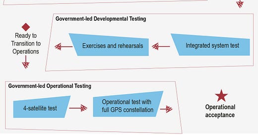
A continuing sore spot is RTX Corp.’s RTX 0.00%↑ $7.6 billion Next Generation Operational Control System, known as OCX, which has drawn the ire of lawmakers because of delays and huge cost overruns. The GAO report said the system of 17 ground stations for current and improved GPS satellites, will not be ready on the delivery date in October. The report said that the U.S. Space Forces will test the system to see whether it can be operational by December 2025.
Despite the huge importance of PNT to the U.S. military, and because there are so many committees in the Pentagon, stewardship of GPS has become a “when everyone is in charge, no one is” scenario, said Dana Goward, Resilient Navigation & Timing Foundation president. In addition, committees, military services and labs each have projects for non-GPS PNT, but none seem to be coordinated, he said.
“Most of our PNT comes from GPS and we have nothing else on the horizon. If GPS signals are not available for any significant amount of time…well, we don't want to live through that day or week,” Goward said.
The GAO report said that while the Space Force has made progress in developing user equipment, years of delays have increased risks to deliver capabilities to the military. These include testing of microchips and cards that process M-code signals.
Expert nationwide installation services for fleet technologies.
u-blox Partners With Wireless Logic, Launches Asset Tracking Service
Thalwil, Switzerland-based u-blox has partnered with UK-based IoT giant Wireless Logic to integrate Wireless Logic’s Conexa network into select u-blox cellular modules. The integration allows businesses and developers to offer connectivity solutions for automotive, industrial, healthcare, and smart cities.
The deal allows companies to deploy IoT solutions at scale by given them greater control and visibility over their deployments and accelerated time-to-market, the company said.
The company, last week, also rolled out its CloudTrack asset tracking service that offers contractless per-location-request plans worldwide, the company said. CloudTrack offers energy savings that is six times greater than standalone GNSS fixes at a cold start and operates indoors without a GNSS connection, the company said.
CloudTrack also features the company’s Thingstream SIM card, LENA-R8 LTE Cat 1bis module with integrated M10 GNSS receiver.
In other u-blox news:
Absolute Cycling the u-blox MAX-M10S GNSS receiver to provide positioning for its latest cycling computer device, The One.
The D-Day Visitor's Handbook: Your Guide to the Normandy Battlefields and WWII Paris by Kevin Dennehy and Steve Powers. The D-Day Visitor’s Handbook includes everything you need to know to plan and make your visit to the site of the biggest seaborne invasion in history. This compact guidebook not only describes the most significant land invasion of World War II, but provides detailed battlefield maps and tours, identifies monuments and attractions, and locates museums and historical sites to make your planning easier and less stressful.
The guidebook uses location technology from what3words to locate monuments, museums and other attractions. Get your guidebook today!
Viasat Grabs $153 Million Contract to Support Blue Force Tracker Program
Viasat V 0.00%↑ SAT has received a five-year contract from the Defense Information Services Agency, potentially worth $153 million, to provide network services and support for the U.S. Army’s Blue Force Tracker (BFT) program. The contract calls for a base year with four one-year option periods.
BFT network, which has been around for more than 20 years, has provided location information for thousands of military vehicles. The contract allows for a BFT network modernization initiative that allows U.S. military and allied forces to share near real-time situational awareness and GPS data, maps and graphics, the company said.
Viasat will provide engineering services and deliver operational and technical support for the BFT network. This includes maintenance and configuration of hardware and software packages.
In other company news, Viasat has announced that Pulsar International has joined its ELEVATE program. Pulsar, a satellite communications and connectivity solutions provider, plans to will use Viasat’s satellite network for niche use cases across markets like agriculture, energy, utilities, mining and for governments, the company said.
Pulsar offers the Tracertrak management system for personnel and asset tracking, and fixed asset management, the company said. Pulsar recently supported Brazil’s 2022 Municipal Elections using Viasat’s satellite network for connectivity in remote locations.
Registration for ION GNSS+ 2024 is open. Don't miss out on early registration rates.
ION GNSS+ 2024 is set to take place Sept. 16-20, 2024 at the Hilton Baltimore Inner Harbor in Baltimore, Maryland, USA.
Other Location News
News tip? Send them to kdennehy@driverlessreport.com. Go to www.locationbusinessnews.com for more news and an archive of stories. Location Business News is looking for your company’s product use cases to feature in each issue. Send us five paragraphs and an image/photo for consideration. Include a contact name, phone, email and web address.
Top News:
🛰 Space Force Defends Plan To Buy Smaller, Cheaper Satellites To Reinforce GPS. “Despite the military’s push for R-GPS, the House Appropriations’ defense subcommittee has raised concerns about whether simply adding more satellites would effectively counter jamming threats, suggesting that alternative PNT systems might be more effective.”
🚚 Geotab, Kia, and 42dot Join Forces to Drive the Future of Fleet Management. “This partnership builds upon Kia's PBV business strategy – to offer software solutions seamlessly integrated with the vehicle, with FMS (Fleet Management System) as the core differentiating factor.”
🌍 Galileo Satellites Enter Service After In-Orbit Testing.
☹ Russia Could Target Undersea Cables and GPS To Cripple Western Communication, Says NATO. “NATO is sounding the alarm about a potential threat from Russia to disrupt vital communication and navigation systems. It warns that Russia may already have plans in place to target undersea fiber optic cables and scramble GPS signals as retaliation for Western support of Ukraine.”
📲 Apple to Launch 'Find My' Network in South Korea Next Spring. “Apple AAPL 0.00%↑ has announced it will finally introduce its popular Find My network to South Korea in the spring of 2025, after apparently overcoming local regulatory hurdles. The launch will bring the full range of Apple's location-based Find My services to South Korean customers for the first time, enabling them to keep track of devices, belongings, and loved ones.”
😕 GPS Faces Growing Competition from China’s BeiDou. “The oldest [GPS] satellite has been in operation for 27 years, a time when Blockbuster was booming, cell phones were clunky bricks, and Google GOOG 0.00%↑ was still called ‘BackRub’ (just learned that odd tidbit).”
🤔 What the New UWB EU Regulations Mean for RTLS. “The latest EU regulation (2024/1467), issued on May 27, 2024, marks a significant milestone for location-based services using UWB technology. This regulation encompasses extensive updates on UWB usage in motor vehicles, railway systems, and even aircraft.”
✔ Leica Geosystems Launches Leica iCON Trades Solution. “Leica Geosystems, part of Hexagon, announced the launch of the new Leica iCON trades solution, which includes the Leica iCON iCS20 and the Leica iCON iCS50 sensors paired with industry-tailored construction layout workflows.”
🛰 Isro Says Multiple Levels of Data Products Generated From Recently Launched Earth Observation Satellite. “On Aug. 16, Isro launched EOS-08 carrying payloads featuring new technology developments in satellite mainframe systems on board a Small Satellite Launch Vehicle from the Satish Dhawan Space Center . Two days later, the GNSS-R instrument on the EOS-08 satellite commenced operations.”
😧 Mathematical Proof Confirms Five Satellites Required for Precise GPS Navigation.
Maps:
📳 Apple Maps Has 12 New Features in iOS 16 You Need to Know About. “It's finally possible to create a route with multiple stops in the Maps app. Before, you could only add pit stops during navigation, and those could only be for gas stations, coffee shops, fast food, parking, banks, and convenience stores. Now you can plan out and set every stop before you start directions.”
🌏 TomTom Supports Radar To Deliver Innovative Location-Based Experiences. “Radar leverages TomTom’s global location data to help power its geocoding and search APIs, supporting use cases across various regions and industries, including the retail, travel, and fintech sectors.”
📱 Google Maps Rival Gets New Feature To Become a More Advanced Waze Alternative. “Sygic has long been a top navigation product, but despite the app being positioned as a Google Maps alternative, it also included an incident reporting module that placed it in the same group as Waze.”
🗺 TomTom’s Orbis Maps Leverages Open Data from Overture Maps Foundation.
Webinar Promotion. Are you getting enough industry execs to sign up for your webinars? We’ve been promoting them for 15 years and know the ins and outs of webinar marketing. We will run a one-month campaign (with weekly reminders on our social media as the webinar gets closer). This includes ad placement in the newsletter, social media posts and a dedicated. email blast to our subscribers. We really hit it hard on social media in the final five days as people always register at the last minute. Email us at info@driverlessreport.com for more information, or click here to view our one-page media kit.
Connected and Autonomous Vehicles:
🏛 Self-Driving Truck Company TuSimple Settles Fraud Lawsuit for $189 Million. “TuSimple reached a $189 million settlement of a lawsuit accusing the self-driving truck technology company of defrauding shareholders by overstating its safety record and concealing three insiders' control of a Chinese trucking rival.”
💲 Waymo’s Robot Taxis Are Almost Mainstream. Can They Now Turn a Profit? “Now that its technology is showing it can work on city streets, Alphabet, which owns Waymo, plans to invest billions more.”
😮 Tesla Will Need Some Hollywood Magic for Its Robotaxi Reveal. “Bloomberg reported that Tesla TSLA 0.00%↑ was planning on using [Warner Brothers] lot in Burbank, California, to reveal its next-generation robotaxi on October 10th. And…Tesla Full Self-Driving Is Finally Coming To Europe And China In 2025.
😐 Mobileye's China Gamble Backfires: How Chaos in the World's Largest Car Market Cut Its Value by Two-Thirds. “Dependence on China has turned into a nightmare for the autonomous vehicle leader.”
🚛 Gatik AI Exec Unpacks the Regulations That Could Shape the AV Industry. “Gatik’s vice president of government relations tells Tech Brew that a controversial California bill would be a “poison pill” for the autonomous trucking sector.”
🚗 Nuro Is Branching out Into Robotaxis and Personally Owned Autonomous Vehicles. “The delivery robot company says it will license its Nuro Driver technology to automakers and mobility providers.”
🤷♂️ Why the Self-Driving Car Craze Slowed Down. “Like so much else, the COVID pandemic was a turning point with AVs. Seeing companies shut down put pressure on ridesharing companies to cut costs.”
🚘 BYD To Use Huawei's Autonomous Driving System. “BYD partnered with Huawei to integrate Huawei’s advanced autonomous driving system, Qiankun, into BYD’s off-road Fang Cheng Bao electric vehicles.”
👍 BAE Systems Unveils ‘ITAR Free’ Autonomous Combat Vehicle at Land Forces.
Fleet:
📌 Teletrac Navman Expands Fleet Management Integrations with EKOS. Teletrac Navman has integrated its TN360 fleet management platform into EKOS Fleet Fuel and EV Management solutions.
🚍 AMCS Acquires Qv21 Technologies, Strengthening Its Transportation Management Capabilities. “Qv21 Technologies’ fleet management and logistics SaaS solutions to support improved waste-to-resource conversion and sustainability for organizations.”
Financial:
💰 Forterra $75 Million Series B Aimed At Driverless For Defense And Industry.
💲 Fleet-Tracking Startup TransTRACK Raises $12 Million To Expand Into Singapore, Malaysia. “Founded in 2019 by Anggia Meisesari and Aris Pujud Kurniawan, TransTRACK offers an AI- and IoT-powered fleet management system, transportation management system, and truck appointment system for logistics companies that aim to optimise their operations.”
Location Industry Briefs
Send your news releases to kdennehy@driverlessreport.com. Go to www.locationbusinessnews.com for more news and an archive of stories.
OneWeb Technologies Introduces Packaged PNT Solution
OneWeb Technologies has announced the commercial availability of its Astra solution that allows LEO SATCOM connectivity and performance when GNSS signals are unavailable or compromised. Astra consists of a software-defined outdoor receiver with access to A-PNT broadcast service.
The Astra receiver processes PNT signals from GNSS and other alternate sources and frequency bands. The solutions pairs with a non-GNSS A-PNT broadcast services, such as Iridium $IRDM. OneWeb is a subsidiary of Eutelsat Group.
Contact: OneWeb Technologies, https://eacowt.com.
Geotab Awarded Contract for Telematics Solution, Sign Deal With Kia, 42dot
Geotab has been awarded a contract from the Delaware Department of Transportation for telematics solutions for fleet management. Through a Sourcewell contract, DelDOT plans to use the telematics systems for state vehicles.
Geotab says its telematics solutions will provide the agency with real-time tracking, advanced data insights, and reporting capabilities. The company recently received the go-ahead to perform the largest telematics contract from the General Services Administration (GSA).
In other company news, Geotab signed a deal with Kia and 42dot for a global connected vehicle partnership. “This strategic collaboration will integrate advanced data solutions with enhanced in-vehicle technology to deliver innovative systems that support safety, sustainability, and efficiency for fleets worldwide,” the company said.
Contact: Geotab, www.geotab.com/government.
HERE and SBD Automotive Announce EV Index
HERE Technologies in collaboration with SBD Automotive unveiled a second annual Electric Vehicle (EV) Index, which reveals notable growth in EV adoption and infrastructure development across the United States and Europe. Delaware surged to the top of the U.S. ranking, moving from 15th place to 1st driven by strong growth in high-power charging and a notable increase in EV sales, the company said.
Separately, the companies launched an Electric Vehicle (EV) Index for India. The Index, coinciding with World EV Day on September 9, ranks a list of selected Indian states and union territories based on key metrics that influence the adoption and usability of EVs, the company said.
In other company news, Thailand-based SKOOTAR is leveraging HERE Geocoding and Routing application programming interfaces (APIs) to optimize its search and routing capabilities for its delivery operations.
Contact: Jordan Stark, HERE Technologies, (312) 316-4537, jordan.stark@here.com.
Quuppa Partners With ZulaFly
Quuppa has partnered with healthcare and asset management solutions company ZulaFly to offer location-based services. Quuppa will integrate its RTLS technology with ZulaFly’s asset management and safety solutions. The companies plan to target such industries as healthcare, manufacturing and logistics.
Contact: Stephanie Andreson, ZulaFly, (701) 541-5786, stephanie.andreson@zulafly.com.
Suntech Rolls Out OBDII Device for GPS Tracking
Suntech’s newest OBDII device features real-time GPS tracking with advanced telemetry data. Some applications include usage-based insurance, pay-as-you-drive, and pay-how-you-drive for engine diagnostics.
Other features include advanced telematics data, Bluetooth gateway, motion sensor, LTE Cat M1 and NB2-IoT compatibility.
Contact: Tim Newburg, Suntech USA, tnewberg@suntechus.com, www.suntechus.com.
BMW Customers in Germany Can Pay Fuel Bill With Parkopedia
With Parkopedia’s Refueling Payments and Parking Payments services, BMW customers in Germany can now pay their fuel bill digitally from their vehicle at participating service stations in all vehicles with BMW Operating System 8, 8.5 and 9. In total, more than 500,000 customers in Germany can pay fuel bills directly from their BMW, the company said.
When searching for petrol stations in BMW Maps, a check mark can also be set for online payment in the settings, both without active route guidance and along the active route. The customer can track past payments and refueling processes at any time in the service in the vehicle and in the My BMW app.
Contact: Adam Calland, Parkopedia, 44(0)7838219129, adam.calland@parkopedia.com.
Link Labs to Offer Asset Tracking System for Elections Equipment and Personnel
Link Labs offers its asset tracking system for elections that enhances the transparency and accountability of in-person and mail-in voting processes, the company said. The system is a solution for creating an inalterable, auditable chain of custody for election equipment and personnel, the company said. Designed for county and local governments, the comprehensive system integrates Link Labs' Supertag and AirFinder Ultra technologies.
Contact: Michael Tebo, for Link Labs (571) 835-8775, michaelt@gabrielmarketing.com.
Wingbits and GEODNET Partner
Flight-tracking service Wingbits has partnered with GEODNET Foundation to develop and commercialize professional-grade terrestrial flight tracking nodes. The Wingbits network has grown to more than 2000 ADS-B stations globally, the company said.
Under the partnership, GEODNET and Wingbits will jointly qualify new flight tracking nodes to provide ADS-B and RemoteID tracking data. The two nodes are outdoor-qualified with multiple networking options, the company said.
Contact: GEODNET, info@geodnet.com, www.geodnet.com.
Create a FREE ManyMe Account.
Trimble Announces 2024 Ovation Award Winners
Trimble TRMB 0.00%↑ has announced the winners of the 2024 Ovation Awards, which recognizes its transportation and logistics segment customers. Winners include Tracso, Tucker Freight Lines, Polaris Transportation Group, Ashley Furniture, NFI, Landstar Transportation Logistics, Ocean State Job Lot and Billy Barnes Enterprises. All companies have implemented Trimble Fleet Manager and other company solutions.
In other company news, Trimble opened a new office in suburban Portland, Ore.
Contact: Trimble, www.trimble.com.
Silicon Labs Supports Bluetooth Channel Sounding
Silicon Labs SLAB 0.00%↑ has announced it will support Bluetooth Channel Sounding technology on the xG24 platform. Bluetooth Channel Sounding is a protocol stack designed to enable distance measurement between two Bluetooth Low Energy (BLE) connected devices.
With PBR and RTT, Bluetooth Channel Sounding can be used in such applications as smart locks, locating consumer electronic devices, and pet trackers. It can also be used in industrial and commercial applications like geofencing, vehicle keyless entry, and access control, the company said.
Contact: Silicon Labs, www.silabs.com.
RailPulse Launches Platform for Railcar Telematics
RailPulse has announced the launch of its technology infrastructure that provides near real-time data and insights across the North American freight railcar fleet. The platform leverages GPS and other telematics technologies to monitor the location, condition and health of railcars. RailPulse is now open for enrollment and said it welcomes stakeholders from across the industry to join the technology transformation.
Contact: RailPulse, sales@railpulse.com, www.railpulse.com.
Sanborn Map Company Equipping Aircraft Fleet With Survey Technology
Sanborn Map Co. said it has equipped its aircraft fleet with geophysical survey technology developed and produced by the company. Some of the tech includes wingtip pods and a tail “stinger” that houses a sensitive magnetometer to enable capture of detailed subsurface data crucial for mapping geological structures and natural resources, the company said.
In addition, Sanborn aircraft are outfitted with wingtip extenders and tail “stinger” for subsurface magnetic survey and geological mapping. This new tech pairs with the company’s imagery, lidar, and multi-spectral data collections.
Contact: Tom Harrington, Sanborn Map Co., (617) 413-7057, tharrington@sanborn.com, www.sanborn.com.
Cambridge Mobile Telematics Earns Frost & Sullivan's 2024 Market Leadership Award
Frost & Sullivan has announced that Cambridge Mobile Telematics won its 2024 Market Leadership Award for innovations in the telematics insurance and connected claims industry. Frost & Sullivan analysts across the telematics landscape, analyzing both the established telematics service providers and the up-and-coming players in the industry, the company said. The company's AI-driven platform, DriveWell Fusion integrates with insurer applications to provide real-time crash detection, automated claims processing and proactive customer engagement.
Contact: Lindsey Whitaker, Frost & Sullivan, (210) 477-8457, lindsey.whitaker@frost.com.
People
Thales Alenia Space hired Giampiero Di Paolo as deputy CEO, SVP of observation, explication, and navigation, and CEO of Thales Alenia Space Italia.
Mariam Sorond, CEO of NextNav NN 0.00%↑ has joined the Forbes Technology Council.
Ambroise Popper has left NextNav to work with startups and help entrepreneurs. Popper was CEO of Nestwave.
Davis Siksnans has been named CEO at Mapon.
Advanced Navigation has named Wayne Prender as global head of defense.
Cambridge Mobile Telematics has announced Rima Khetab's appointment as the director of sales for France and Benelux.
Chris Oldham has been named vice president of sales EMEA at Hologram Inc.
Ilian Papasov has been named head of market strategy at Velocity IoT.
Nick Werle has been named strategic account manager at Mapbox.
Jobs
Senior Demand Generation Manager. Point One Navigation.
LEO-PNT System Engineer. ESA.
Strategic Enterprise Sales. TomTom.
Product Manager - Autonomous Driving. TomTom.
Program Manager. Swift Navigation.
Senior Full Stack Developer. Where You At.
Data Engineer. Atomic Maps.
Click HERE to Join our growing Location Business News LinkedIn Group!