Wipro and HERE Partner To Provide Location-Based Services
The Deal Supports Several Industries Globally

Wipro Limited [WIT] and HERE Technologies are partnering to offer location-based services to energy, utility, transport and logistics, telecom, automotive and other industries.
As part of the deal, the companies said they will develop asset tracking, logistics, supply chain, smart-metering and analytics, field workforce management, and private mapping-as-a-service for indoor and outdoor real-time asset tracking. Specifically, the companies are developing a IoT-based smart metering product to provide information about energy consumption and asset management.
HERE Tracking will help Wipro’s customers monitor and track assets, field engineers and supply chain on a real-time basis both indoor and outdoor, as well as provide analytics to build operational efficiencies, the company said.
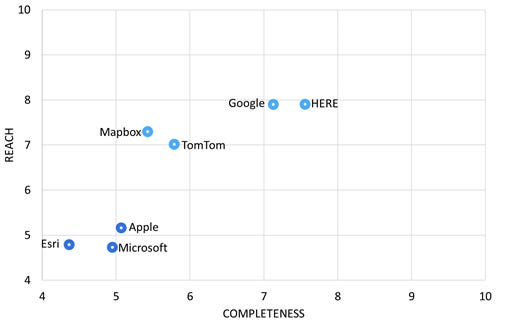
In other HERE news, the company said it was ranked as the top location platform by industry analyst firm Omdia. The 2021 index assesses the seven leading global providers of location data and services including Google, Apple, Mapbox and TomTom.
The index evaluated vendors on the completeness of their platform and their platform’s market reach, Omdia said. The index considered the core capabilities of a location and mapping platform along with associated services, the supporting ecosystem, and business models.
Contact: Sebastian Kurme, HERE, 49 173 515 3549, sebastian.kurme@here.com.
U-Blox Says FCC’s Ligado Decision May Hurt Autonomous Vehicle and 5G Growth
Thalwil, Switzerland-based u-blox [UBXN] said it cautions against negative impacts of the FCC’s recent approval of the use of a previously protected portion of the L band for terrestrial communication on global navigation satellite systems (GNSS) such as GPS.
The FCC, on Jan. 19, 2021, voted down a proposal by U.S. government agencies to stop its decision that allows Reston, Va.-based Ligado Networks to deploy a nationwide mobile broadband network. At that time, such companies as Lockheed Martin [LMT], Iridium Communications, Air Line Pilots Association, Association of Equipment Manufacturers, International Air Transport Association and Airlines for America filed petitions to ask the FCC to reconsider Ligado’s bid.
U-blox says Ligado, because of the recent FCC decision, will be free to use frequencies “very close to those used by GNSS receivers, to transmit downlink signals from cell towers and uplink signals from user equipment.”
U-blox contends the signals threaten to disrupt GNSS receiver operation from “any manufacturer operating in the vicinity of a Ligado base station or compatible cellular handset.” The company said it conducted an internal study of the susceptibility of u-blox GNSS receivers and confirmed the transmissions would disrupt the operation of nearby receivers.
The company said autonomous cars and trucks could be negatively affected because GNSS is the “only available source of absolute position information that most automotive manufacturers now recognize as being vital for high levels of autonomy.”
The company argues that public 5G cellular networks “will require many more base stations than 4G networks.” U-blox contends that GNSS receivers will be required to keep these base stations in synch.
Ligado is storming ahead with its 5G mobile satellite network for IoT, partnering with Mavenir to develop base stations. The company also named former NASA Administrator Charles Bolden Jr. to its board.
Contact: Natacha Seitz, u-blox, 41 764 36 0788,natacha.seitz@u-blox.com, www.u-blox.com.
Pebblebee Launches Asset Tracker With Polte Location Technology
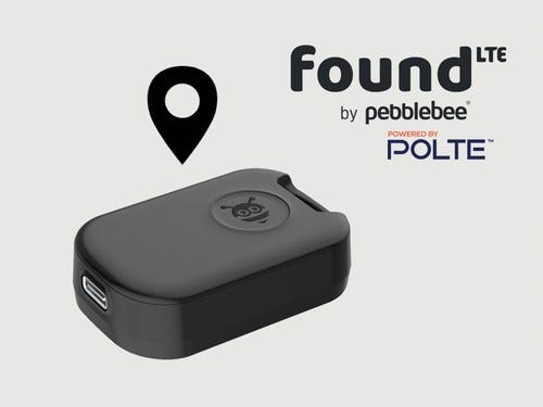
Pebblebee said its latest generation of Found asset recovery devices will include Polte 4G/5G Massive IoT cellular location technology.
The Polte technology allows Found LTE devices to leverage existing cellular infrastructure and secure cloud computing for indoor and outdoor use, which extends beyond the range of BLE and GPS.
“By leaning on Polte’s cloud-based cellular location technology beyond where BLE can reach, rather than GPS, the device is able to significantly cut cost and power drain for a range of use cases including pet and general enterprise asset tracking,” said Daniel Daoura, Pebblebee founder and CEO, in a statement.
The product, which costs $149 with a one-year subscription thrown in, will be marketed to both consumer and enterprise markets.
Polte’s positioning capability is provided through an API to preclude the expense of hardware, access points, or beacon deployments, the company said.
Pebblebee, founded in 2012, has shipped more than 1 million units to such retailers as Costco, according to their website. These units range from dog trackers to TV control and wallet finders. The company said that Found LTE is being shipped to “thousands of preorder customers” with initial rollout in the U.S. and Canada.
The company said its employees come from Google, Apple, Microsoft, Boeing, Hewlett-Packard, GE, HBO and others.
Contact: Christina Wicker, Polte, (949) 527-0923, christina@polte.com, www.polte.com; Pebblebee, contact@pebblebee.com.

Space Force Says Eighth GPS III Satellite Available for Launch
The U.S. Space Force’s Space Systems Command recently declared the eighth GPS III satellite as “Available for Launch.” GPS III SV06, SV07, and SV08 are ready for launch and are located at Lockheed Martin’s [LMT] GPS III Processing Facility in Waterton, Colo.
The first of the three recently completed satellites, SV06, is scheduled to launch in 2022 and will join the operational constellation of 31 GPS satellites, Space Force said.

GPS III also expands the civilian L5 signal, currently broadcast by the 12 GPS IIF satellites, but not yet operational, delivers a new L1C signal designed to grant interoperability to similar international space-based position, navigation and timing systems worldwide, Space Force said.
Contact: Space Systems Command, (310) 653-1131, smcpa.media@us.af.mil, www.ssc.spaceforce.mil.
Other Location News:
News tip? Send them to kdennehy@driverlessreport.com. Go to www.locationbusinessnews.com for more news and an archive of stories.
🛰 Space Force Now Says Its Most Important Mission Is Protecting GPS Satellites. “The Space Force, battling the perception it has no purpose, emphasized satellite defense in a new recruiting video.”
🚎 Waymo Will No Longer Sell Its ‘Laser Bear Honeycomb’ Lidar Sensors To Other Companies. “Waymo first began manufacturing its own lidar sensors in early 2017 as a way to dramatically reduce the costs of its autonomous vehicle business. At the time, the company said that by making its own sensors, it could lower the unit price from $75,000 for an off-the-shelf lidar sensor to just $7,500.”
🚗 Toyota Halts All Self-Driving E-Palette Vehicles After Olympic Village Accident. “It shows that autonomous vehicles are not yet realistic for normal roads,” said Toyota Chief Executive Akio Toyoda. Editor’s Note: Toyota resumed vehicle testing.
✔ AT&T Adds Sub-6 GHz 5g for Enterprise IoT. “NB-IoT and Cat-M networks often support low-power devices that are less complex and don’t use that much data, like smart meters and for asset tracking.”
🚐 What is DeepMotion, the technology that Xiaomi has just bought to conquer the autonomous vehicle market. “A way of describing what they are capable of through different sensors – ultrasonic radars, fisheye cameras and GPS positioning modules – and their own data manager in the cloud, the Cloud-Car, whose archive houses thousands of high-resolution maps and different simulated scenarios on them.”
Advertisement
Have you ever been reluctant to reveal your personal email address online or in person?
The answer is almost universally YES! So, if you happen to be one of those who thinks twice about these matters, ManyMe might be the answer to your worries.

Location Industry Briefs
Send your news to kdennehy@driverlessreport.com. Go to www.locationbusinessnews.com for more news and an archive of stories.
Comtech Awarded $4.7 Million Contract with Channel Partner
Comtech Telecommunications Corp. [CMTL] has a been awarded a $4.7 million contract from a “channel partner” to supply new releases to messaging application software for a U.S. tier-one mobile network operator, the company said. The contract, awarded to Comtech’s Trusted Location group, as well as an earlier contract with “a Canadian tier-one mobile network operator” to supply 5G location services.
Contact: Comtech, (631) 962-7005, investors@comtech.com, www.comtechlocation.com.
Hemisphere GNSS Announces Outback Guidance MaveriX Precision AG
Hemisphere GNSS rolled out its MaveriX Precision AG solution, which is built around the new MaveriX agriculture application software platform. The MaveriX application software includes a new user interface that provides tablet-like user experience with improved 3D graphics, the company said.
The unit also features the A631 GNSS Smart Antenna, which delivers GNSS performance at scalable accuracy levels using RTK, SBAS, and Hemisphere’s Atlas L-Band service, the company said. The A631 also supports RTK Base functionality when paired with the Outback RTK radio option.
Contact: Hemisphere GNSS, (480) 348-6380, press@hgnss.com, www.hgnss.com.
Spirent Federal Launches Alternative RF Navigation Simulator
Spirent Federal [SPT] has launched its RF navigation simulator. Spirent Federal’s product, as GPS jamming and spoofing continue to rise, simulates resilient alternative RF navigation signals on its own or concurrently with GNSS signals, the company said. Testing can be static or dynamic, with stationary, pedestrian and ground vehicle trajectories available, the company said.
Contact: Jeff Martin, Spirent Federal Systems, (801) 787-1207, jeff.martin@spirentfederal.com, www.spirent.com.
JAVAD GNSS Seeks Companies For Dealer Network
JAVAD GNSS is seeking well-qualified companies to grow their global dealer network. If companies are interested to sell and support some of the most advanced GNSS devices on the market, click here to learn more: https://lnkd.in/eqEDUGjU.
Aero-Graphics Wins GPSC Contract
Aero-Graphics has signed a five-year, multimillion-dollar Geospatial Product and Services Contract (GPSC) with the U.S. Geological Survey (USGS) to provide surveying and mapping services, the company said. The USGS plans to populate and maintain databases of mapping and geospatial data. The contract will help to populare these databases, the company said.
Contact: Aero-Graphics, (801) 487-3273, www.aero-graphics.com.
Kyocera and Nagasaki University Develop Energy Harvesting Smart Buoy to Collect Ocean Data
Nagasaki Univ. and Kyocera have jointly developed an Energy Harvesting Smart Buoy, which combines Nagasaki University's tidal current power generation technology with Kyocera's IoT technology to collect ocean data. A pilot program gathered information from 21 sensors, monitoring everything from water temperature and humidity to current direction.
A buoy equipped with a tidal-current power generation system supplies power to the Kyocera GPS multi-unit and connected sensors, the company said. The GPS multi-unit is a compact Kyocera IoT device, equipped with various sensors and antennas, compatible with GPS, GLONASS, and Michibiki location tracking systems.
Contact: Kyocera, 81-(0)75-604-3416, webmaster.pressgl@kyocera.jp, https://global.kyocera.com.
Jobs
Javad GNSS is looking for new talent to join their team! JAVAD GNSS.


