Alphabet To Invest $5 Billion in Waymo
Large investment comes as Waymo expands further into San Francisco
So much for autonomous vehicle funding drying up. Alphabet GOOG 0.00%↑ announced this week that it will invest $5 billion in its Waymo self-driving car unit.
The funding announcement, which was announced at the company's second-quarter earnings call, comes as the business unit Waymo belongs to reported $365 million in quarterly revenue. CEO Sundar Pichai said that Waymo completes 50,000 paid rides each week in both San Francisco and Phoenix.
“We are greatful for [Alphabet’s] immense vote of confidence in our team and recognizing the amazing progress we’ve made with our technology, product, and commercialization efforts,” said co-CEO Tekedra Mawakana, who confirmed the huge investment, in an X post.
The announcement comes at around the same time that rival GM’s GM 0.00%↑ Cruise self-driving unit said that they would indefinitely delay the product launch of Origin. The Cruise vehicle is a self-driving shuttle bus.
In addition, Tesla TSLA 0.00%↑ also delayed its August launch of its CyberCab robotaxi to Oct. 10.
Expert nationwide installation services for fleet technologies.
Overture Maps Foundation Announces General Availability of Open Maps Datasets
Overture Maps Foundation has announced the General Availability (GA) of several of its global open maps datasets, which is a free alternative to mapping data provided by Google GOOG 0.00%↑ and Apple AAPL 0.00%↑. The organization, which is part of the Linux Foundation, said the release will pave the way for new use cases for mapping applications and geospatial analysis.
“The data in this GA release is already powering use cases in local discovery, insurance, and mapping industries, and we expect many more use cases in the coming months from industries ranging from automotive to ride-sharing and more,” said Marc Prioleau, Overture Maps Foundation executive director, in a statement. “Getting to GA is a major milestone because it opens the gates for adoption by map developers. As the map data gets used, developers and users will provide feedback which creates mechanisms for continuous improvement.”
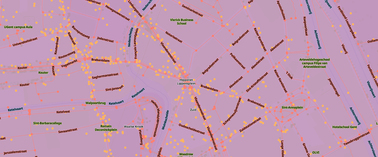
The release includes Buildings, which are 2.3 billion unique building footprints worldwide that already are featured by Microsoft’s MSFT 0.00%↑ Bing Maps, Esri’s ArcGIS Living Atlas of the World, and Addresscloud’s insurance service platform. Other rollouts include Places of Interest, which offers data on almost 54 million places worldwide; Divisions that feature national and regional administrative boundaries; and Base contextual layers, including land and water data.
The foundation also rolled out its Address theme, which includes 14 countries with more than 200 million addresses. Overture said that while companies access address data from open data sources, they are hampered by different licenses, formats, and schemas. Addresses through Overture will have unique identifiers to enable rapid attachment of outside data.
In addition to Microsoft and Esri, Overture members TomTom [TOM2] and Meta META 0.00%↑ are incorporating the foundation’s datasets into their services and products.
Apple Maps Launches on Web in Beta
In other mapping news, and a big shot across the bow of Google Maps, Apple said it would make its Maps available, in beta, on the web. The maps will feature both walking and driving directions, ratings, and reviews.
The update is one of the largest Apple has made since launching Maps 12 years ago. The web availability, on both desktop and mobile, allows users to do everything an iOS version does: Order food from Maps, search for businesses and other information.
Developers, including those using MapKit JS, can link out to Maps on the web, the company said. In addition, while Maps on the web is only available in English right now, it is compatible with Safari and Chrome on Mac and iPad, Chrome and Edge on Windows PCs.
The D-Day Visitor's Handbook: Your Guide to the Normandy Battlefields and WWII Paris by Kevin Dennehy and Steve Powers. The D-Day Visitor’s Handbook includes everything you need to know to plan and make your visit to the site of the biggest seaborne invasion in history. This compact guidebook not only describes the most significant land invasion of World War II, but provides detailed battlefield maps and tours, identifies monuments and attractions, and locates museums and historical sites to make your planning easier and less stressful.
The guidebook uses location technology from what3words to locate monuments, museums and other attractions. Get your guidebook today!
Company Says Its GPS Technology Can Overcome GPS Jamming and Spoofing
Sunnyvale, Calif.-based oneNav is touting test results in Israel that showed its GPS technology is resilient to widespread interference, including jamming and spoofing. The company, which has been featured in the national media this week, tested its L5 technology around Haifa, Israel, in smartphones and smartwatches, the company said.
In a warzone, oneNav tested its L5-direct GPS receiver against receivers found in iPhone, Samsung Galaxy, Google Pixel smartphones and Garmin $GRMN watches. The company said the tests revealed that all the embedded receivers failed due to GPS interference—except its L5-direct.
“We now have clear, indisputable evidence that L5-direct is resilient to widespread GPS jamming and is able to provide precision location in GPS-contested environments,” said oneNav CEO Steve Poizner, in a statement. “This test is a real-world validation of our first-of-its-kind technology and shows the potential for L5-direct to revolutionize how we use GPS for civilian and military purposes in Israel and globally.”
The company, which offers a video of the test, said that the outdated L1 GPS signal is not doing the job. In addition, while GPS receivers in smartphones, car navigation systems, and airplanes are able to process the L5 band, they can only do so in a hybrid system that must first acquire L1. This hybrid requirement constitutes an “enormous national security and public safety risk,” the company said.
OneNav cites interference in Ukraine, where Russia is hampering American-made smart bombs and drones on the battlefield through GPS-jamming technology. Russia also is accused of interfering with GPS navigation systems in more than 46,000 flights across Europe.
There are additional hurdles to the adoption of the L5 signal and associated equipment—one is that it can’t work in most existing GPS receivers. In addition, the L5 signal needs the GPS Next-Generation Operational Control System, or OCX, but it has been delayed for years.
Registration for ION GNSS+ 2024 is open. Don't miss out on early registration rates.
ION GNSS+ 2024 is set to take place Sept. 16-20, 2024 at the Hilton Baltimore Inner Harbor in Baltimore, Maryland, USA.
Other Location News
News tip? Send them to kdennehy@driverlessreport.com. Go to www.locationbusinessnews.com for more news and an archive of stories. Location Business News is looking for your company’s product use cases to feature in each issue. Send us five paragraphs and an image/photo for consideration. Include a contact name, phone, email and web address.
Top News:
🏛 Geotab’s Postal Service Tracking Contract Withstands Challenge. Samsara IOT 0.00%↑ lost its protest of a U.S. Postal Service contract to Geotab USA awarded under a $300 million procurement for telematics fleet-tracking devices, the U.S. Court of Federal Claims said in an opinion.
💰 Cipia Secures Telematics Aftermarket Order for 40,000 Vehicles. “Cipia has received an order for 40,000 licenses of its driver monitoring software, which will be integrated into an aftermarket fleet camera system to serve one of the world’s largest express delivery companies.”
🙁 America at Risk From China, Lack of GPS Alternatives. “[T]he National Security Space Association (NSSA) warns that America is over-dependent on GPS, has no real alternatives, and is far behind China and Russia. Both of those nations have terrestrial backups for space-based navigation and timing signals.”
⚡ FCC Rule May Finally Bring Total Nationwide Next-Gen 911. “The new FCC rules will require phone and Internet companies to deploy NG911 core services networks within six to 12 months of getting a request from a local call center.”
📌 Airbus Looking at Opportunities To Create Scale in Space, Satellites. “Airbus is looking at opportunities to create scale in defence, space and particularly satellites markets, said CEO Guillaume Faury. Airbus and France's Thales are exploring a tie-up of some space activities as new competition disrupts the sector, two industry sources said last week.”
🚍 Coast Raises $40 Million for Fleet Management Solutions. “Coast raised $40 million this week. The company offers fleet payments by leveraging vehicle data and telematics.”
🤔 State of the Global Geospatial Industry 2024. Trimble’s TRMB 0.00%↑ white paper on the state of the geospatial industry.
👍 Test Flight Demonstrates Navigation by Cellphone Signals. “The new technique could protect against GPS spoofing.”
🛰 India Contracts Firm for NavIC Receiver. “To move towards self-reliance in the navigation space, India’s Defense Research and Development Organization has contracted with Accord Software and Systems to develop receiver chip specifically for the Indian Regional Navigation System (IRNSS), also know as NavIC.”
🌎 The CubeCat-4, a New Nanosatellite, Is Already Orbiting the Earth. “The nanosatellite will measure weather and climatic phenomena from space using a GPS and Galileo navigation signal reflectometer (GNSS-R) and a microwave radiometer.”
Maps:
🗺 Wherobots has joined Overture Maps Foundation to support the next generation of planetary-scale open map data Overture datasets through Overture Maps Foundation’s use of the open-source Apache Sedona projects.
🤨 Is Anyone Else Sick of This Unreliable Google Maps Tool? “Google Maps' algorithm for finding a "faster route available" is rarely helpful and frequently makes things worse.”
😐 Google Maps vs. Waze on CarPlay: The Best Navigation App After the Latest Updates. “Despite Google Maps winning the race on iPhone and CarPlay, the app still lacked essential features, sometimes feeling like a significantly downgraded experience from Android and Android Auto. Two of them are the speedometer and support for traffic reports.”

Webinar Promotion. Are you getting enough industry execs to sign up for your webinars? We’ve been promoting them for 15 years and know the ins and outs of webinar marketing. We will run a one-month campaign (with weekly reminders on our social media as the webinar gets closer). This includes ad placement in the newsletter, social media posts and a dedicated email blast to our subscribers. We really hit it hard on social media in the final five days as people always register at the last minute. Email us at info@driverlessreport.com for more information, or click here to view our one-page media kit.
Connected and Autonomous Vehicles:
🙁 GM's Cruise Abandons Origin Robotaxi, Takes $583 Million Charge. “GM GM 0.00%↑ reported a financial charge of $583 million in the second quarter that is tied to the non-cash write-off of Origin assets and other restructuring costs. The Cruise subsidiary had an operating loss of $1.14 billion in the second quarter that included a $605 million impairment charge. “
🤞 Elon Musk Sets New Date for Tesla Robotaxi Reveal, Calls Everything Beyond Autonomy Noise. “Elon Musk says he will show off Tesla’s TSLA 0.00%↑ purpose-built “robotaxi” prototype during an event Oct. 10, after scrapping a previous plan to reveal it Aug. 8. Musk said Tesla will also show off ‘a couple of other things,’ but didn’t explain what that meant.”
🏛 Waymo Is Suing People Who Allegedly Smashed and Slashed Its Robotaxis. “Waymo attorneys said in court papers that the alleged vandalism, which ruined dozens of tires and a tail end, are a significant threat to the company’s reputation.”
🛺 Ohmio’s Autonomous Vehicles Are Running at JFK Airport. “The Port Authority of New York and New Jersey recently announced a pilot program at JFK featuring autonmous vehicles from the New Zealand-based company Ohmio.”
🏎 Indy Autonomous Challenge Racecar Sets Self-Driving Hill Climb Speed Record. “After three runs, the [PoliMOV-MSU] racecar broke the record on the third and final Goodwood Hill run at 111.2 mph in 66.37 seconds. Roborace’s DevBot 2.0 driverless automobile set the previous record in 2019 at 101.16 mph (162.8 km/h) in 66.96 seconds. The hill climb is 1.14 miles from a standing start.
Drones:
🛩 India’s IdeaForge Integrates Inertial Lab’s Lidar into Commercial UAV Solutions. “This collaboration integrates Inertial Labs’ RESEPI LiDAR solution into ideaForge’s unmanned aerial vehicles.”
Location Industry Briefs
Send your news releases to kdennehy@driverlessreport.com. Go to www.locationbusinessnews.com for more news and an archive of stories.
Swift Navigation Reaches 10 Million Vehicle Milestone
Swift Navigation has announced that it has been awarded contracts that will equip 10 million ADAS-enabled and autonomous vehicles with its location technology. The company said that its Skylark Precise Positioning Service is addressing the three barriers to L3 autonomy—reliability, cost, and safety—at scale. Skylark, integrated with its Starling Positioning Engine, analyzes external threats to accuracy and delivers GNSS corrections in compliance with Automotive Safety Integrity Level (ASIL) standards, the company said.
Contact: Swift Navigation www.swiftnav.com.
EtherWhere Raises $16.3 Million
Milpitas, California-based etherWhere Corp. announced it raised $16.3 million in a new funding round. The funding, led by Cambium Capital, Walden International and a “U.S.-based strategic investor,” will be used for the development of next generation of low power products, expansion of engineering talent and customer support, the company said. EtherWhere offers its AccuWhere cloud technology to complement its location offerings.
Contact: Jimmé Peters, for etherWhere, (503) 816-0500, jimme@24-7consulting.com, www.etherwhere.com.
What3Words Partners With ShipEngine
Shipping API company ShipEngine and what3words have partnered. ShipEngine allows online retailers and their shipping partners provide accurate, consistent and efficient deliveries, the company said.
Contact: What3words, www.what3words.com.
Digital Matter Expands Bluetooth-Enabled GPS Devices with G70 BLE and Dart3 BLE
Digital Matter recently added Bluetooth Low Energy to their Dart3 and G70 GPS vehicle and equipment tracking devices. With cellular LTE-M (Cat-M1)/NB-IoT connectivity, the devices can be used for driver and vehicle monitoring.
The G70 BLE and Dart3 BLE now support concurrent GPS tracking and BLE monitoring. The BLE capability allows for the monitoring of fuel levels, fuel flow rates, axle load meters, tire pressure, and temperature, the company said.
Contact: Shay Kettner, Digital Matter, shay@digitalmatter.com, www.digitalmatter.com.
Sheeva.AI Partners With P97 Networks
Sheeva.AI has partnered with P97 Networks to offer the SheevaConnect in-car payments solution to P97’s fueling partners. The deal follows Sheeva.AI’s announcement earlier this spring that drivers of the Citroën C3 Aircross SUV can purchase fuel at thousands of gas stations throughout India, the company said. For P97 Networks, the partnership adds to their mobile commerce platform that allows oil companies and c-store chains to attract and retain retail fueling customers, the company said.
Contact: Trevor Curwin, Sheeva.AI, (415) 646-6043, tcurwin@sheeva.ai, www.sheeva.ai.
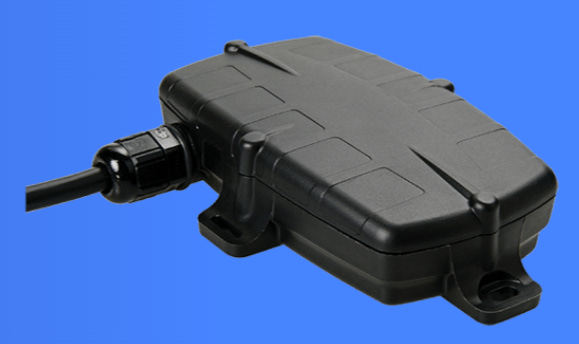
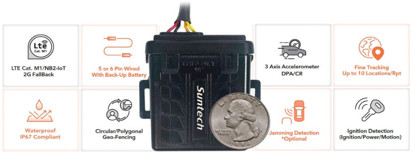
Suntech Offers Wired Tracking Device
Suntech has rolled out its 5pin or 6pin wired tracking device for fleet management, heavy equipment, insurance/security companies, and/or logistics companies. The tracking device is designed to work with LTE networks (Cat M1, NB2-IoT, 2G).
Other features include GPS tracking, internal antennas, a rugged IP67 rated enclosure, a backup battery in case of loss or tampering, the company said.
Contact: Tim Newberg, Suntech, tnewberg@suntechus.com, www.suntechus.com.
U-blox Announces ZED-F9P Firmware Update
Thalwil, Switzerland-based u-blox has announced a firmware update for the ZED-F9P-05B module for such uses as robotic lawnmowers, UAVs, surveying and mapping. Key firmware updates include Galileo OSNMA to detect spoofing attacks.
Other features include improved SPARTN performance that enhanced the functionality of the company’s PointPerfect service.
Contact: Natacha Seitz, u-blox, 41 76 436 0788, natacha.seitz@u-blox.com.
Create a FREE ManyMe Account.
Korea’s LG U+ Certifies Telit Cinturion Chipset
Telit Cinterion said that South Korea’s LG U+ has certified the NE310L2 series of LTE Cat NB2 modules for use on its network. The series is the first low-power wide area (LPWA) NB-IoT module based on Sony’s Altair ALT1255 chipset to be approved by LG U+, the company said.
The NE310L2-W1 module features a 13.1×14.3 mm footprint for such uses as smart meters, medical/ fitness wearables, home automation and asset trackers. Other key features include a power-saving mode, extended temperature range and pin-to-pin compatibility, the company said.
Contact: Telit Cinterion, www.telit.com/cellular-lpwa.
Flow Labs Partners With Geotab ITS
Flow Labs has partnered with Geotab Intelligent Transportation Systems to offer new performance metrics and eventually platform features for freight and commercial vehicle insights so that traffic managers can address safety, congestion, and environmental impact on their roadways, the company said. Flow Labs’ digital twin platform uses AI to integrate multiple data streams including signal data, detection data, and connected vehicle data into a traffic management platform. With Geotab’s data, the Flow Labs platform provides traffic managers and modelers with a historical breakdown of roadway use by vehicle type, class, vocation and industry, the company said.
Contact: Flow Labs, www.flowlabs.ai.
Quectel Launches First Quad-Band GNSS Module
Quectel Wireless Solutions has launched its LG290P, the first quad-band GNSS module. The module features RTK availability and centimeter-accuracy for precision agriculture, robotic lawn mowers, surveying and personal robots, the company said.

The LG290P is compatible with Quectel’s triple band RTK Services. The quad-band solution can enhance the RTK fix rate by 50 percent, with a first fix reduced to less than five seconds, the company said.
Contact: Quectel, media@quectel.com, www.quectel.com.
Safran Updates Skydel GNSS Simulation Engine
Safran has updated its Skydel GNSS simulation engine to support such new signals as QZSS L6, NavIC L1 and NavIC S-band. These enhancements are available on Skydel-based platforms like the GSG-7 and GSG-8, the company said. The company said users can upgrade now to the Skydel version 24.6.
Contact: Safran, www.safran-navigation-timing.com.
Quupa Certifies Indoor Location Installers
Quuppa has launched its Certified Installer Certification that allows partners to deliver indoor positioning services, setting a new benchmark in the industry. The initiative certifies installers to ensure customers receive high-quality location data, the company said. The training includes detailed modules on system design, installation best practices, troubleshooting, and maintenance, the company said.
Contact: Quuppa, www.quuppa.com.
Wyld Networks Launches Satellite Tracker
The Wyld Connect AT452 Satellite Tracker, for location-based tracking, uses low Earth orbit satellites for global coverage. The tracker, first deployed in Brazil, features data received directly through the satellite constellation, eliminating the need for extra ground-based infrastructure, the company said. Use cases include tracking for containers, pallets, unmanned floating platforms, buoys, agricultural equipment and others.
Contact: Alastair Williamson, Wyld Networks, 44 7 824 997 689, alastair.williamson@wyldnetworks.com.
Appdome Adds Geo Features
Appdome has announced that its Geo-Fraud Detection service will include Geo-Location Fencing and Geo DeSync Attack Detection. Combined with other Geo-Compliance features available on the Appdome platform, mobile app developers and enterprises can eliminate location-based fraud, ensure geo-compliance and deliver location relevant user experiences in mobile apps free from location spoofing, fake location, VPNs, Fake GPS Apps and other threats, the company said.
Contact: Appdome, www.appdome.com/mobile-fraud-detection/geo-compliance.
People
Craig Lozofsky will be stepping down as COO at MOTER and Aioi USA at the end of the month.
Pointr has named Tolga Kılıç as our GIS/CAD expert.
Jobs
Group Product Manager, Telematics Experience. Ford.
Senior Data Scientist. TomTom.
Regional Sourcing Specialist, Geospatial Data. TomTom.
Software Engineer - IV (Big Data Design & Development). TomTom.
ADAS Product Owner. Jaguar Land Rover.
Careers. Xona Space Systems.
GNSS R&D Engineer. Trimble.
Inside Sales Representative. Telit Cinterion.
VGI Business Development Manager. The Mobility House.
Click HERE to Join our growing Location Business News LinkedIn Group!


