Easter Jamming: 63 Hours of GPS Signal Attacks
GPS signal jamming increasing as Israel braces for retaliatory attack…
Hundreds of passenger jets were affected by an alleged Russian attack on GPS signals in the Baltic region earlier this week. The attack, which started on Easter Sunday and lasted more than 63 hours, occurred as tensions are rising between NATO and Russia since the Ukraine invasion more than two years ago.
According to published reports, most of the GPS signal attacks took place in Polish airspace. However, more than 1,600 commercial airliners operating in German, Danish, Latvian, Lithuanian and Swedish airspace have reported interference.
The increase of GPS jamming as an offensive and defensive military measure has experts concerned where the constellation stands compared to others. “Our fact-finding has led us to the conclusion that, as miraculous as it is and despite a long history of upgrades, GPS has fallen behind,” said Jeffrey Shane, a member of the National Space-Based Positioning, Navigation and Timing Advisory Board, in a LinkedIn post. “Moreover, despite 20 years of White House directives, the U.S. still has no back up system. Given the vulnerability of GPS to interference, the implications for national security are serious.”
Jamming GPS signals is being used as a defensive strategy by Israel as it braces for a retaliatory attack from Iran, or its surrogates, after an attack this week that killed 13 people, including a high-ranking Iranian military officer. GPS is being block across entire areas of Israel to disrupt missiles, bombs and drones, according to published reports.
The website that monitors GPS jamming, appropriately named GPSJAM, showed massive amounts of interference across Israel. The country’s northern border with Lebanon already has GPS jamming in place.
“Interesting that the spoofing seems to be moving users to the airports in Beirut and Cairo. This is reminiscent of spoofing often reported in Moscow and other locations inside Russia,” said Dana Goward, Resilient Navigation and Timing Foundation president, in a LinkedIn post. “It is particularly effective against drones, many of which have been programmed at the factory to avoid airports.”
Expert nationwide installation services for fleet technologies.
AGCO, Trimble Complete Ag Acquisition, Joint Venture
The largest location industry deal made last year has been completed. As part of a joint venture, AGCO AGCO 0.00%↑ acquired 85 percent of Trimble’s TRMB 0.00%↑ precision agriculture assets for $2 billion.
The joint venture, announced last September, will be known as PTx Trimble. The acquisition combines Trimble’s precision ag business with AGCO’s JCA Technologies unit to form a new company.
Trimble will retain a 15 percent stake in the new unit. However, the new PTx Trimble entity will be consolidated into AGCO’s financial statements. AGCO financed the transaction through a combination of $1.1 billion in recently issued senior unsecured notes, a $500 million term loan facility, other borrowings and cash on hand, the company said.
Iridium Completes Acquisition of Satelles
Saying the $115 million deal establishes it as a leader in satellite-based time and location services, Iridium Communications IRDM 0.00%↑ has announced that it completed its acquisition of Satelles. The purchased company will now be called Iridium Satellite Time and Location (STL).
"The initial feedback we've gotten from partners in the short time since the initial announcement has made us even more excited about Iridium STL's potential. We're ready to step on the gas and expand the availability of Iridium STL to markets around the world," said Iridium CEO Matt Desch, in a statement.
In other completed acquisitions:
PowerFleet PWFL 0.00%↑ has completed its acquisition of MiX Telematics for $18.7 million. The combined business will be branded as PowerFleet, with its primary listing on Nasdaq, the company said. Steve Towe will remain CEO of PowerFleet and David Wilson will remain CFO. Stefan Joselowitz, current CEO of MiX, will be retiring, the company said.
The D-Day Visitor's Handbook: Your Guide to the Normandy Battlefields and WWII Paris by Kevin Dennehy and Steve Powers. The D-Day Visitor’s Handbook includes everything you need to know to plan and make your visit to the site of the biggest seaborne invasion in history. This compact guidebook not only describes the most significant land invasion of World War II, but provides detailed battlefield maps and tours, identifies monuments and attractions, and locates museums and historical sites to make your planning easier and less stressful.
The guidebook uses location technology from what3words to locate monuments, museums and other attractions. Get your guidebook today!
CMT Study Says Distracted Driving Fell by 4.5 Percent
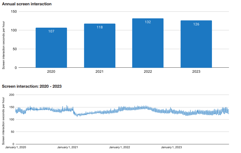
Telematics service provider Cambridge Mobile Telematics (CMT) has released its annual report on distracted driving and road safety, “The State of US Road Risk in 2024,” that says distracted driving fell by 4.5 percent in 2023, the first decrease since 2020.
The report evaluates the various factors that can reduce distracted driving, including consent-driven usage-based insurance (UBI) programs, hands-free legislation, and increased media coverage of the dangers of distracted driving. The company estimates this reduction in distracted driving helped prevent more than 55,000 crashes, 31,000 injuries, 250 fatalities, and close to $2.2 billion in economic damages.
“While it’s great to see that distracted driving declined in 2023 after years of trending upward, every second that drivers use their phone behind the wheel puts all road users at risk,” said Matt Fiorentino, CMT’s vice president of marketing, in a statement. “From consent-based UBI programs to hands-free laws, this decline shows that we have the tools to fight distracted driving.”
It seems as if U.S. drivers are 187 percent more distracted than those in the United Kingdom, CMT says. “In 2023, US drivers spent 2 minutes and 6 seconds interacting with their phones each hour they drove. While this marks a six-second decrease from 2022, this figure is still 17 percent higher than it was in 2020,” according to the report.
CMT also found that drivers were distracted in the minute before a crash in 34 percent of crashes.
CMT’s report, The State of US Road Risk in 2024, is available now and can be downloaded here.
Other Location News
News tip? Send them to kdennehy@driverlessreport.com. Go to www.locationbusinessnews.com for more news and an archive of stories. Location Business News is looking for your company’s product use cases to feature in each issue. Send us five paragraphs and an image/photo for consideration. Include a contact name, phone, email and web address.
Top News:
🛰 DoD Releases 2024 DoD Commercial Space Integration Strategy.
🚜 John Deere Execs say Starlink Solution Lays the Groundwork for the Autonomous Future of Farming. “John Deere DE 0.00%↑ announced its selection of Starlink in January after a long RFP process that launched in 2022. Deere will sell an aftermarket kit solution through its dealer network that includes a ruggedized Starlink terminal and a cellular modem to connect agricultural machines to the John Deere Operations Center.”
😮 Canoo Spent Double Its Annual Revenue on the CEO's Private Jet in 2023. “Canoo posted Monday its fourth-quarter and full-year earnings for 2023 in a regulatory filing that shows a company burning through cash as it tries to scale up volume production of its commercial electric vehicles and avoid the same fate as other EV startups, like recently bankrupt Arrival.
Maps:
🤷♂️ Comment: Google Maps for Carplay Is a Disaster Compared to the Android Auto App. “The Google Maps experience for CarPlay is barebones, to say the least. Opening the app just dumps you into the map. No navigation targets or anything in view.”
📱 The Useless Waze Feature I Always Disable on My Devices. “A feature that doesn't make sense and which I always disable on all my devices is the option to show other Wazers on the map. While I find it hard to understand why it's there, the option to see other users by viewing their "mood" on the map was fun at first when the map was much simpler. The addition of more map elements, which contributed to a more cluttered interface, made the Wazers icons almost useless, turning it into a feature that should no longer be there.”
⚽ LA Football Club Uses what3words. “LAFC uses what3words to help find precise locations at the venue, such as entrances, exits, the ticket office, and more. Every 10-foot square has been given a unique combination of three words: a what3words address.”
🗺 Google Maps Hidden Features That You Must Know To Make Navigation Easy. “Gemini AI Integration: With Google Maps' integration with Gemini AI, you can now navigate to a specific location using voice commands, making it convenient, especially while biking.”
Reach nearly 14,000 subscribers and 100,000 more via social media by advertising in Location Business News!
We can promote your webinar, service or product to a focused group of industry executives. Email us at info@driverlessreport.com for more information, or click here to view our one-page media kit.
Connected and Autonomous Vehicles:
☹ Apple Lays off 614 Workers After Ditching Self-Driving Car Project.
🚘 New York City to Allow Driverless Car Tests. “City officials said that they would begin to permit operators to test drive autonomous autos on New York City streets.”
🚗 Waymo Self-Driving Cars Are Delivering Uber Eats Orders for First Time. “Uber Eats customers may now receive orders delivered by one of Waymo's self-driving cars for the first time in the Phoenix metropolitan area.”
👍 Waymo Begins Testing Self-Driving Cars in DC. “D.C. residents may have already seen the company’s vehicles – all-electric Jaguar I-Pace sedans outfitted with sensing equipment on the exterior of the vehicle – driving around the city.”
🤔 How Automakers Can Address Resistance to Self-Driving Cars. “Our new research, published in the Journal of the Association of Consumer Research, reveals a bias impeding the embrace of automated vehicles: human egotism.”
Drones:
🛩 Russian Drone Flew 23 Kilometers Over Romania Before Hitting Ground. “According to sources, it was a Russian drone that was supposed to attack Ukrainian Danube ports, but its GPS guidance system likely failed.”
Financial:
💲 How Inrix Inked a $70M Deal With Morgan Stanley. “Inrix scrapped IPO plans due to a market downturn. The Kirkland-based traffic management company instead landed $70 million as it continues to seek an exit for its shareholders.”
Location Industry Briefs
Send your news releases to kdennehy@driverlessreport.com. Go to www.locationbusinessnews.com for more news and an archive of stories.
Overland AI Awarded $18.6 Million U.S. Army Robotic Combat Vehicles Contract
Overland AI has received an $18.6 million contract from the U.S. Army and the Defense Innovation Unit (DIU) for a two-year Ground Vehicle Autonomous Pathways (GVAP) program to develop a prototype autonomy stack for the U.S. Army’s Robotic Combat Vehicle (RCV). Overland AI will adapt its OverDrive solution to prototype autonomous vehicles capable of traversing complex terrain in contested areas without GPS support, the company said.
OverDrive can operate in any rugged and contested environment, including areas with limited or no communications, the company said. OverDrive uses passive sensors to avoid detection and doesn’t need pre-mapped routes since it uses on-board sensors to interpret the surrounding terrain in real time, the company said.
Contact: Kristen Hoff, for Overland AI, (888) 317-4687, ext. 702, kristen@firecrackerpr.com, www.overland.ai.
Telit Cinterion Launches GNSS Module
Telit Cinterion has launched its SE868K5-RTK GNSS module that is capable centimeter-level accuracy, the company said. Designed for operation near cellular or other radios, the SE868K5-RTK is a multifrequency and multiconstellation positioning receiver.
Other features include Real-Time Kinematics (RTK) capabilities and dual frequencies (L1/E1 and L5/E5). The SE868K5-RTK module can ingest corrections generated by customers’ local base stations or streamed by corrections service providers such as Swift Navigation’s Skylark Precise Positioning Service.
Contact: Telit Cinterion, www.telit.com.
WhereSafe GPS Launches Advanced Tracking App
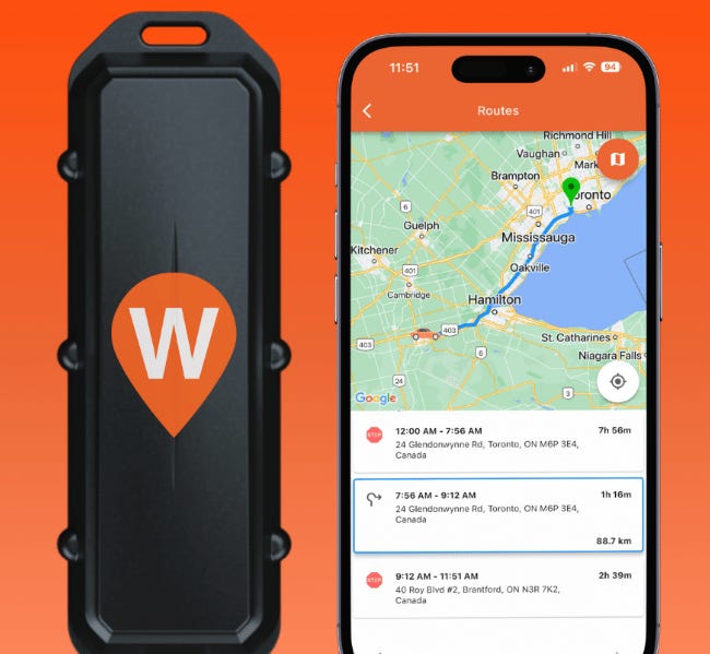
WhereSafe GPS has launch of its improved GPS tracking app and a refreshed website, the company said. The company rolled out its One Tracker that features real-time GPS tracking, customizable geofencing, and detailed history logs.

In other company news, WhereSafe GPS has revamped its website, wheresafe.com, to streamline the shopping experience for GPS tracking solutions, the company said.
Contact: Shaun Gratrix, WhereSafe GPS, (416) 805-9265, shaun@wheresafe.com, www.wheresafe.com.
U-blox Launches Bluetooth Modules
Thalwil, Switzerland-based u-blox [SIX:UBXN] has launched its ALMA-B1 and NORA-B2 modules that are based on the latest generation nRF54 Series Systems-on-Chip (SoCs) from Nordic Semiconductor. They both support Bluetooth LE 5.4 and Thread/Matter technologies.
ALMA-B1 and NORA-B2 are designed for a wide range of IoT applications, including industrial automation, healthcare, and smart home, the company said. In an indoor positioning example, ALMA-B1 could act as an anchor point due to its processing capabilities, while the power efficiency of NORA-B2 makes it suitable for asset tracking tags, the company said.
Contact: Natacha Seitz, u-blox, 41 76 436 0788, natacha.seitz@u-blox.com.
Sanborn Geophysics Offers TDEM System
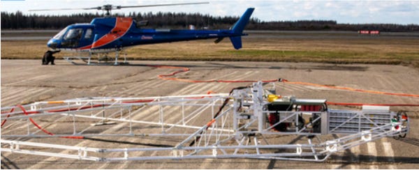
Sanborn Geophysics’ helicopter-borne Time Domain Electromagnetic (TDEM) system supports minerals, metals, groundwater, and geological hazard mapping. The compact size of Sanborn Geophysics TDEM shortens the time for deployment and makes it suitable for all types of terrain, the company said.
The company also offers its Integrated Multi-Parameter Airborne Console (IMPAC), which is a navigation and real-time data acquisition system that integrates MMS-8 magnetometer processing for geological structures and hazards mapping.
Contact: Tom Harrington, Sanborn Geophysics, tharrington@sanborn.com, https://sanborn.com/sanborn-geophysics.
Create a FREE ManyMe Account.
Penguin and ZulaFly Partner
Penguin Location Services and ZulaFly have partnered to offer healthcare location-based workflow and safety solutions. Penguin offers location-based products supporting enterprise navigation, real-time locating, and safety applications. Penguin's AI/ML algorithms allow 5.1 Bluetooth Low Energy (BLE) enabled devices to be leveraged as a high-performance location transponder, the company said.
Contact: Penguin Location Services, www.penguinin.com.
Spatial Technology Solutions Announces Upgraded GPS Tracking Services
Spatial Technology Solutions (STS) has announced upgrades to its GPS tracking services in Bahrain. The improved GPS technology offers more precise and reliable real-time tracking, allowing users to pinpoint the exact location of their vehicles at any given time, the company said. The upgraded system also boasts advanced geofencing functionalities, the company said.
Contact: Ahmed Zainal, Spatial Technology Solutions, 973 1778 9409, ahmed.zainal@sts-int.net, https://sts-int.net.
ATrack Technology Launches Telematics Devices
ATrack Technology is rolling out telematics solutions at Embedded World 2024 that include the AK750 AI telematics box, which supports both GEO and LEO connectivity with LTE redundancy, the company said.
The AK750 GEO/LEO AI telematics box addresses connectivity challenges in remote environments, especially in rural or remote areas lacking cellular or fiber infrastructure, the company said.
Contact: ATrack Technology, 886-2-2797-5852, marketing@atrack.com.tw.
GNSS-Based On-Board Units Deployed for Road User Charging Exceeds 7 Million Units
Berg Insight, in a new study, says GNSS-based RUC/ETC systems that are in operation or about to be launched in the relative near-term are found in Europe, but there are also programs in operation in North America and Asia-Pacific. Berg Insight estimates that the installed base of GNSS-based on-board units deployed for road user charging reached more than 7.4 million units worldwide in 2023. Growing at a compound annual growth rate (CAGR) of 7.3 percent, the installed base is forecasted to reach almost 10.6 million units in 2028.
Contact: Johan Fagerberg, Berg Insight, 46 31 711 30 91, johan.fagerberg@berginsight.com.
People
ORBCOMM has announced that Christian Mezger has joined the company as CFO.
Brightly, a Siemens company, has named Christine Engle, senior vice president of people and organization; and Nigel Hughes, head of product.
CONTROLTEK has named Brian Gross as its CFO.
Veriff has announced the appointment of Jeffrey Guy as president and COO.
Pointr has named Sasha DeMarino as vice president of customer success.
Dwight Hakim has joined MOTER Technologies as vice president, insurance business development.
Andy Marchant has been named director of product marketing at TomTom.
Stass Borm has been named global human resources director - Project Management and People Operations with HERE Technologies.
Jobs
Director - Business Models & Planning. Stellantis.
Senior Product Manager, Commercialization. Waymo.
Sales Representative NE, Heavy Construction. Leica Geosystems.
Software Development Manager. Mappedin.
Agile Center of Excellence (CoE) Director. Ford.
Deputy Chief, Office of Strategic Communications. National Reconnaissance Office.
Click HERE to Join our growing Location Business News LinkedIn Group!


