ESA Awards Three Contracts Worth $253 Million for Navigation Missions
ESA's FutureNAV program includes Genesis and LEO-PNT
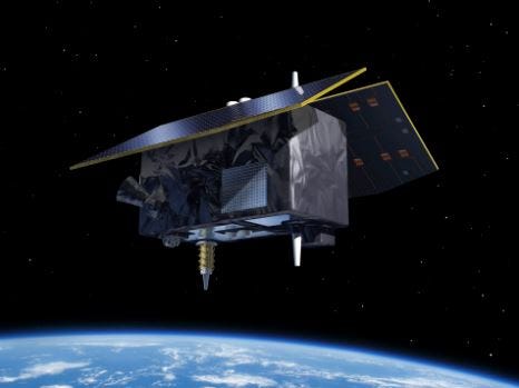
The European Space Agency this week awarded $253 million for three contracts that fund two satellite navigation missions. The navigation missions, Genesis and LEO-PNT, are part of ESA’s FutureNAV program.
“With Genesis and LEO-PNT we are responding to rapidly growing needs for more resilient and precise navigation and ensuring Europe leads global satellite navigation, the largest downstream space market,” said Javier Benedicto, ESA director of navigation, in a statement.
The 76.6 million euro contract for Genesis, developed by a 14-company consortium led by OHB Italia and scheduled to launch in 2028, will contribute to an International Terrestrial Reference Frame (ITRF) with an accuracy of 1 millimeter. An updated ITRF impacts satellite-based systems, such as Galileo satellites, ESA said.
The other two contracts, both for 78.4 million euros, went to GMV Aerospace and Defence and OHB System and Thales Alenia Space for LEO PNT, expected to be in orbit by 2027. The contracts call for the design and development of satellites and payloads, ground segment, test user segment and satellite launches, operations, experimentation and demonstration of services with end users, ESA said.
For its part, Thales Alenia Space will deliver space, ground and user segments for the LEO-PNT orbit demonstrator. This includes five satellites that will be launched.
The contract also calls for in-orbit operations that include deorbiting, the launch itself, test user segment and experimentation and service demonstration with several industries and different user environments, the company said.
The constellation will work with Galileo and other satellite navigation to provide “guaranteed centimeter location accuracy, robustness, resistance against jamming and spoofing as well as low-latency, the company said. The LEO-PNT orbit demonstrator will allow increased accuracy and other features to such emerging applications as autonomous vehicles, uncrewed aerial and maritime vehicles and 56/6G ground telecom network synchronization, the company said.
“Adding a LEO-PNT constellation layer to the Galileo GNSS, combined with improved user receivers, will unlock new applications and economic growth while bringing essential environment benefits reducing CO2 emissions through fuel saving and a more efficient energy network,” said Hervé Derrey, Thales Elenia Space CEO.
It’s Official: SpaceX To Launch Four Galileo Satellites
In related ESA news, the European Union and the United States have reached a security agreement that allows the launch of four Galileo navigation satellites onboard SpaceX’s Falcon 9 rocket, according to Politico. The EU has agreed to pay 180 million euro for two launches, which have military and civilian payloads—hence the security.
It’s been a tough road for Galileo as Europe ended its relationships with Russia, which was to launch its satellites, when it invaded Ukraine in February 2022. Another option, the Ariane 5, was retired—and the Ariane 6 has been delayed.
Expert nationwide installation services for fleet technologies
Companies Launch Products for Mobility Markets
Swift Navigation and Telit Cinterion have launched a joint product that integrates Swift’s Skylark Precise Positioning Service with Telit Cinterion’s GNSS modules. Use cases include wearables, robotic lawn mowers and vehicle tracking devices.
The partnership, with integration of Skylark into such Telit Cinterion modules as its SE868SY-D, will be targeted to customers developing next-generation of location-based apps for navigation, worker safety, fleet management and asset tracking, the companies say.
The companies say while precise positioning already enables devices to be located with centimeter accuracy, the challenge has been to integrate location technology into smaller battery-powered devices.
U-blox Launches Its First Dual-Band GNSS Platform Combining L1 and L5
In another product announcement this week, Thalwil, Switzerland-based u-blox [SIX:UBXN] rolled out the F10, which is company’s first dual-band GNSS platform combining L1 and L5 bands. The platform will be marketed to such urban mobility applications as aftermarket telematics and micromobility.
“GNSS receivers in urban environments suffer from reduced position accuracy because of satellite signals being reflected by buildings or other objects - multipath effect. The new F10 GNSS products use L1/L5 dual-band signals and mitigate the multipath effects,” said Bernd Heidtmann, u-blox Positioning Product Center product manager. “The result is a far better position accuracy in urban environments compared to GNSS L1 single-band products.”
Heidtmann said there are such design challenges as L1/L5 dual-band GNSS receivers require a dual-band antenna, which is larger than a L1 single-band antenna. “The RF circuit is more complex compared to the L1-only bill of material. With u-blox NEO-F10, MAX-F10 or MIA-F10 products this is not a challenge, as the relevant RF components are integrated into the module,” he said.
The company says that while applications that require accurate GNSS positioning are on the rise, many receivers don’t perform well in urban environments. Combined with the L1 band, an L1/L5 dual-band GNSS receiver can deliver less than 2-meter positioning accuracy—compared to about 4 meters with the L1 band only, the company said.
The D-Day Visitor's Handbook: Your Guide to the Normandy Battlefields and WWII Paris by Kevin Dennehy and Steve Powers. The D-Day Visitor’s Handbook includes everything you need to know to plan and make your visit to the site of the biggest seaborne invasion in history. This compact guidebook not only describes the most significant land invasion of World War II, but provides detailed battlefield maps and tours, identifies monuments and attractions, and locates museums and historical sites to make your planning easier and less stressful.
The guidebook uses location technology from what3words to locate monuments, museums and other attractions. Get your guidebook today!
JAXA and MetCom Collaborate on the Terrestrial PNT System
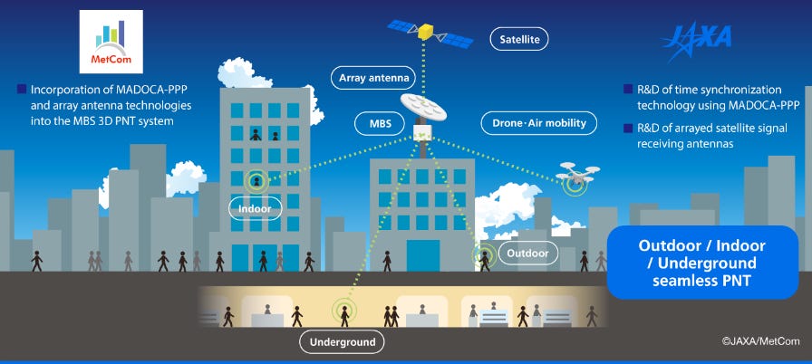
MetCom and Japan Aerospace Exploration Agency (JAXA) are partnering to work on a terrestrial positioning, navigation and timing (PNT) system through the JAXA Space Innovation through Partnership and Co-creation (J-SPARC) program. The project aims to improve the accuracy of time synchronization between base stations, a key contributor to accurate terrestrial PNT, the agency said.
Specifically, the time synchronization information gained through Multi-GNSS Advanced Orbit and Clock Augmentation - Precise Point Positioning (MADOCA-PPP), which uses centimeter-level positioning augmentation signals, will be incorporated into the Metropolitan Beacon System (MBS). This is MetCom’s planned 3D PNT service that will allow location information in urban areas, whether underground, indoors or outdoors, the company said.
MetCom’s MBS 3D PNT service will provide location information whether underground, indoors or outdoors by transmitting positioning signals from proprietary ground base stations to enable the signals to be carried by radio waves at a higher reception strength, the company said. Use cases of the time distribution service include time synchronization for telecommunication systems, financial networks, data centers and power grid networks.
MetCom will incorporate time information, based on MADOCA-PPP, into the time synchronization process of the MBS 3D PNT system, the company said. Compared with using only GPS for time synchronization, the adoption of MADOCA-PPP-based time information is expected to enhance the positioning accuracy between base stations by two digits, the company said.
JAXA will conduct research and development on time synchronization technology using MADOCA-PPP and on array antenna technology. By using array antennas to increase directivity and allowing them to preferentially receive positioning signals from QZSS, JAXA plans to enhance resistance to jamming and spoofing, thereby improving security, safety and reliability, the agency said.
“Through this co-creation initiative with JAXA, we will combine the high interference resistance based on the directivity of QZSS and MetCom’s high signal reception strength distinctive to terrestrial systems, and in addition, capitalize on MADOCA-PPP’s time information, which is higher in accuracy by double digits,” said Hirasawa Hiroki, MetCom representative director, in a statement.
Mike Sheldrick: Journalist and Telematics Industry Veteran
Industry veteran Michael Sheldrick passed away last week. Sheldrick, 82, who worked not only as a journalist for Business Week, Fleet Management Weekly and other publications, was a sought-after speaker at industry conferences and trade shows. In 1990, he authored Driving While Automated for Scientific American, which was many years before autonomous car systems were being produced.
He was a pioneer in the digital map and telematics industries, working at Etak as director, automotive business development. He also held positions at DeCarta, C.J. Driscoll & Associates and other telematics companies.
He was a founding member of Washington-based Intelligent Transportation Society of America. In 1992, he was a co-author of the Strategic Plan for Intelligent Vehicle-Highway Systems in the United States, as part of an industry fellowship with IVHS America, which later became ITS America. The strategic plan was a blueprint that led to the development of such intelligent transportation technologies as telematics, vehicle navigation, maps, vehicle-to-everything communications (V2X), electronic tolling, connected and autonomous vehicles and many others that are in use by millions today.
For more information on Mike Sheldrick go to Fleet Management Weekly for a tribute.
Other Location News
News tip? Send them to kdennehy@driverlessreport.com. Go to www.locationbusinessnews.com for more news and an archive of stories. Location Business News is looking for your company’s product use cases to feature in each issue. Send us five paragraphs and an image/photo for consideration. Include a contact name, phone, email and web address.
Top News:
🙁 US Reaper Drone in Emergency Landing Amid Russia GPS Attacks. “A U.S. military Reaper drone was forced to make an emergency landing during a routine flight in Polish airspace on Tuesday, raising concerns over escalating GPS jamming activities across NATO’s eastern flank, particularly around the Baltic Sea.”
🌍 Russia Jams GPS on UK Defense Minister's Plane: FligGht Forced To Navigate by Alternative Methods as Satellite Signal, Internet Blocked for 30 Minutes. Editor’s Note: It’s not new news, but it happened to a high-level guy’s ride.
👍 Vodafone Expands IoT Coverage to 98 Percent as Customer Demands Continue To Grow. “Vodafone has seen increased demand across numerous industries for a connectivity solution that can support use cases such as industrial and commercial metering, water monitoring, asset tracking, and smart city applications, including air quality monitoring.”
💰 BlackSky Technology BKSY 0.00%↑ has been awarded a $24 million contract by the Air Force Research Laboratory to enhance moving target engagement capabilities through development and demonstration. BlackSky uses AI with satellite technology detection, tracking and identification of moving targets.”
⚡ Sequans gets €11m from French government for 5G eRedCap R&D. French IoT chipmaker Sequans Communications, which saw its $249 million takeover by Japan-based Renesas Electronics come undone at the eleventh hour at the end of last month, has been granted €10.9 million from the French government to go towards development of 5G-based ‘reduced capability’ (RedCap) chips.
🏛 GM, LexisNexis Face Class Action Over Telematics Insurance Data Collection. “A recent legal filing seeking to establish a class action claims the giant jump in premiums was linked to his 2021 Cadillac XT6’s invasive data tracking.”
🚚 Ford Has Big Goals for Software Sales To Small Business Truck Fleets. “Small and medium-sized business fleets in North America and Europe constitute a large enough market that [Ford F 0.00%↑ CEO] Jim Farley has told investors Ford Pro could earn 20 percent of its pre-tax profit from selling software and services within two years.”
Maps:
📱 Waze Not Needed: GPS Could Help Make Every Route Faster. “Researchers analyzed data collected from GM vehicles fitted with GPS sensors to extrapolate traffic dynamics, eventually determining that it's possible to establish patterns that would allow traffic lights to fight congestion and reduce delays. GPS sensors can supply information, including the number of stops at a vehicle, the route selection, and the vehicle delay.”
🤔 Google Maps vs. Apple Maps vs. Waze: The Offline Maps. “Navigation apps have become increasingly smarter, getting new features like real-time traffic reports and notifications to help make every journey more predictable.”
📌 Camptocamp Joins Overture Maps Foundation. “In joining the Overture Maps Foundation, Camptocamp will engage in the Global Entity Reference System (GERS) and the Developer Advocacy working groups.”
🗺 Anyone Can Make an Indoor Map in Minutes.
Reach nearly 14,000 subscribers and 100,000 more via social media by advertising in Location Business News!
We can promote your webinar, service or product to a focused group of industry executives. Email us at info@driverlessreport.com for more information, or click here to view our one-page media kit.
Connected and Autonomous Vehicles:
☹ Mobileye to Close Aftermarket Unit, Lay Off 130. “Israeli advanced driving assistance systems (ADAS) company Mobileye Global MBLY 0.00%↑ has announced that it is closing down its aftermarket solutions unit due to market changes in recent years. The move will result in 130 employees being laid off, including an estimated 90 in Israel.”
😦 NTSB Investigating Deadly Crash in San Antonio Involving a Semi-Autonomous Vehicle. “The Mustang Mach-E is capable of hands-free driving. It can control steering, braking and lane positioning, but still needs drivers’ supervision.”
🛺 NVIDIA DRIVE Powers Next Generation of Transportation — From Cars and Trucks to Robotaxis and Autonomous Delivery Vehicles. “BYD, Hyper, XPENG, Plus, Nuro, Waabi and WeRide Adopt DRIVE Thor.”
🙁 Carmakers' Shady Data Sharing Takes Spotlight in GM Connected Car Scandal. “The heart of the problem is one of GM's GM 0.00%↑ OnStar connected-car services, called Smart Driver.”
🚗 VW Is Ready To Bring Autonomous Driving To Large-Scale Production. “The German automaker is ramping up the AD technology for the VW Buzz AD with Mobileye following an extensive pilot phase in the U.S. and Germany.”
Financial:
✔ Comtech Announces Results for its Second Quarter of Fiscal 2024.
💲 Stellantis Signals Its Continued Confidence in Archer by Further Increasing Its Strategic Shareholding in the Company. “Stellantis N.V. and Archer Aviation ACHR 0.00%↑ announced that Stellantis recently completed a series of open market purchases of 8.3 million shares of Archer’s stock.”
📈 MiX Telematics To Delist From JSE. “MiX Telematics will stop trading on the JSE and New York Stock Exchange (NYSE) in less than two weeks, after fulfilling all conditions for its planned merger with US-based IoT specialist PowerFleet.”
Location Industry Briefs
Send your news releases to kdennehy@driverlessreport.com. Go to www.locationbusinessnews.com for more news and an archive of stories.
Aerospacelab Will Build, Launch Xona Space Systems’ Navigation Satellite
Aerospacelab will design, manufacture and launch Xona Space Systems’ upcoming navigation satellite. Aerospacelab will also assist Xona Space Systems in obtaining operator license and support launch operations for two years, the company said. Xona Space Systems will provide the position, navigation and timing (PNT) payload for integration into Aerospacelab’s platform.
Contact: Aerospacelab, communications@aerospacelab.com, www.aerospacelab.com.
HERE Technologies and Netstar Partner
HERE Technologies has partnered with Australian telematics provider Netstar to enhance asset management and navigation capabilities for commercial and heavy vehicles. The companies, which have partnered since 2008, plan to leverage HERE’s Location Services and Map Content for asset tracking.

This latest phase of the partnership is focused on enhancing truck navigation with Netstar’s use of HERE SDK Navigate, the company said. The companies predict Australia’s road freight will increase by 77 percent between 2020 and 2050
Contact: Katie Kelly, Netstar Australia, 61 404 037 479, katiek@netstaraus.com.au
Trimble Partners With Radiodetection
Trimble TRMB 0.00%↑ and Radiodetection have partnered to integrate Trimble’s Catalyst DA2 GNSS system and Radiodetection’s RD Map+ application and precision locator products. The integration allows customers to streamline utility-locating workflows to create underground utilities maps, the company said.
Data collected with Catalyst DA2 GNSS system can now be synced with RD Map+ and precision locators that find and mark buried utilities, the company said. By streamlining this connection, workers can efficiently and accurately digitize utility-line locations and reduce costly reporting errors, the company said.
Contact: Trimble, www.trimble.com.
Pozyx Updates RTLS
Pozyx’s new release of its Pozyx real-time location system (RTLS) now supports Bluetooth (BLE) positioning and presence detection alongside UWB tags. This allows users to track both types of tags simultaneously for flexibility, the company said.
For applications where pinpoint accuracy is not critical, Pozyx RTLS infrastructure now supports BLE positioning with 5-meter accuracy. For UWB positioning, Pozyx RTLS infrastructure has 10-centimeter accuracy, the company said.
Contact: Samuel Van de Velde, Pozyx, samuel@pozyx.io, www.pozyx.io.
Quectel Partners With The Things Industries
Quectel Wireless Solutions has partnered with LoRaWAN solutions provider The Things Industries to integrate Works with The Thinks Stack and security certifications into the company’s KG200Z LoRaWAN module. The Quectel KG200Z module is powered by the STM32WL by STMicroelectronics.
In other company news, Quectel said that 95 percent of its modules shipped to the United States since early in 2022 have high security scores based on penetration testing and binary analysis conducted by Finite State. In addition to Finite State testing, the company said it “is actively pursuing collaboration with multiple standards-setting organizations to enhance and commit to a more rigorous set of security requirements.”
Contact: Quectel, media@quectel.com, www.quectel.com.
Create a FREE ManyMe Account.
Autocity and Fixposition Partner
Autocity has partnered with Fixposition AG to integrate Fixposition’s Vision-RTK 2 positioning sensor into Autocity’s Guangpo sweeping vehicle. The vehicle features autonomous navigation, obstacle detection and avoidance, automatic waste disposal and weather adaptation capabilities, the company said.
Fixposition says its sensors can deal with urban environments with buildings and foliage that disrupt signal paths with deep fusion technology that combines data from RTK-GNSS, IMU and computer vision systems.
Contact: Adriana Najera, Fixposition, adriana.najera@fixposition.com, www.fixposition.com.
OnAsset Intelligence Launches Dedicated Aircraft IoT Gateway
OnAsset has announced that its flagship SENTRY 600 FlightSafe device has now been deployed as a dedicated aircraft-installed gateway to transform an aircraft itself into a virtual-connected warehouse. This allows an aircraft to be a hub for monitoring aircraft subsystems, sensor-enabled shipments, and detection of ULDs, galley carts and other connected aircraft assets, the company said. OnAsset delivers these solutions to airline customers where Bluetooth sensors are installed in cabin and hold areas to monitor temperature and humidity, the company said.
Contact: OnAsset, (972) 659-1619, media@onasset.com, www.onasset.com.
People
Neil Churman has been promoted to president of Woolpert. Churman takes over as president from Scott Cattran, who remains the company’s board chair and CEO.
Iridium Communications has appointed John McNiff as vice president and general manager of the company’s Space Development Agency business.
Plus has appointed Jon Morrison as its inaugural chief revenue officer (CRO).
Roberto Polli has been appointed global head of IoT sales at Vodafone.
MOTER Technologies has appointed Alan Adkins as vice president of commercial auto.
Ericsson ERIC 0.00%↑ has appointed Andres Vicente as its head of market area South East Asia, Oceania and India and senior vice president.
Woolpert vice president and chief scientist Qassim Abdullah has been selected to serve as a member of the National Oceanic and Atmospheric Administration's Hydrographic Services Review Panel.
Brian Mulshine has been named senior director of product management at Trimble Transportation.
Pointr has hired Tolga Yücel as GIS/CAD expert.
Jobs
Careers. Hexagon’s Autonomy & Positioning.
Job Openings. U-blox.
Director of Operations. Volpe National Transportation Systems Center.
Sales Development Representative - Geospatial & Navigation Solutions. Advanced Navigation.
Business Development Manager - Europe. Esri.
Senior Partner Manager - Europe. Esri.
Renewals Manager. Mappedin.
Transportation Research Board jobs:
Director, Cooperative Research Programs.
Transportation and Smart Infrastructure Program Manager. Battelle.
Account Manager. KORE.
Customer Success Manager. MiX Telematics.
Click HERE to Join our growing Location Business News LinkedIn Group!


