Esri Releases Latest Land Cover Map at User Conference
The user conference, with 15,000 attendees, featured a "who's who" of geolocation companies
Esri has released a global land-use/land-cover map (LULC) of the world, along with partner Impact Observatory, at its San Diego user conference this week. The LULC maps are based on 10-meter Sentinel-2 satellite data for every year since 2017, the company said.
"Users are working with maps that will accurately reflect events and earth processes that are happening in reality. We are constantly updating our land-cover map with new data and features, and this latest improvement ensures that anyone viewing temporal change can be confident what they are seeing represents the natural world," said Sean Breyer, Esri ArcGIS Living Atlas of the World program manager, in a statement.
Esri says the LULC maps “contextualize and quantify the impacts of earth processes” and human activity on the environment. Target markets include government agencies and organizations who will use the maps to improve policies and make land management decisions, the company said.
Esri developed its Sentinel-2 10-Meter Land Use/Land Cover Time Series with the European Space Agency (ESA) Sentinel-2 imagery hosted on the Microsoft MSFT 0.00%↑ Planetary Computer.
At the conference, the company also partnered with The Washington Post on a U.S. “Heat Tracker” that will be used by the venerable newspaper in its climate reporting. The Heat Tracker will use Esri’s spatial data and analytics.
Such Esri partners as Trimble TRMB 0.00%↑ announced products at the conference. The company rolled out its Trimble Terra Office add-in for Esri ArcGIS Pro. Organizations that collect data in TerraFlex, and bring it into ArcGIS, can also use the Trimble Offline GNSS Corrections service, the company said.
Other Ersi UC announcements:
Maxar Technologies announced the initial release of its Maxar Geospatial Platform (MGP) at the conference. The company said MGP will simplify the discovery, purchasing and integration of geospatial data and analytics. Users will have access to Maxar’s geospatial content, including high-resolution satellite imagery and basemaps, 3D models, analysis-ready data, image-based change detection and analytic outputs.
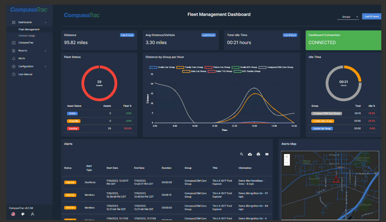
CompassCom Software has released Version 8.2 of its GIS-centric hybrid telematics platform. The platform can be deployed on premises or in the cloud for real-time asset tracking and fleet management, the company said. The platform, developed on Esri ArcGIS technology, can track the status of personnel, vehicles and other mobile assets.
Locana said it is continuing its strategic partnerships with Esri and SAP SAP 0.00%↑ by naming Tom Turchioe as global partnership technology lead.
Near Intelligence NIR 0.00%↑, which was a sponsor of the conference, announced that the location-based insights from its global data sets represent more than 1.6 billion unique user IDs.
FacilityForce announced that it has added map-centric asset management capabilities, called Locate, to its Integrated Workplace Management System (IWMS) software suite. Locate embeds Esri's ArcGIS mapping software into FacilityForce for map-centric asset management, the company said.
Expert nationwide installation services for fleet technologies.
Seven European IoT Providers Sign With EchoStar
Dublin-based EchoStar SATS 0.00%↑ recently announced that seven European IoT service providers have signed multi-year commercial agreements to develop and sell IoT solutions using EchoStar Mobile’s satellite-based LoRa-enabled IoT network.
API K, Cyric, DalesLandNet, Dryad, Galaxy1, ProEsys and Symes, plan to scale IoT deployments for leveraging the real-time network to enable massive IoT deployments for such applications as outdoor personal geo-safety, soil moisture monitoring, early forest fire detection, utility metering and pipeline monitoring. Most of the companies offer tracking and monitoring services. For example, France-based API-K provides tracking services for outdoor activities.
EchoStar Mobile is compatible with Semtech’s SMTC 0.00%↑ LoRa-enabled wireless platform for device connectivity. EchoStar XXI S-band satellite will deliver two-way connectivity across Europe.
EchoStar Mobile Limited is the EchoStar subsidiary in Europe that operates a mobile satellite system (MSS) network using the geostationary EchoStar XXI satellite. EchoStar is developing an S-band constellation of low Earth orbit (LEO) satellites, called EchoStar Lyra, to support IoT connectivity. The company said it plans to explore a global non-terrestrial 5G network in the S-band.
Power Your Business with Vetted Digital Marketing Experts
GrowTal's marketing experts are pre-vetted and experienced, so you can focus on taking your business to the next level. Anywhere from social media management and SEO to paid social channels and high-level strategists. GrowTal experts are ready to work.
Your First Draft, Fast
Looking for some words of inspiration to kickstart your creative process? Magic Write in Canva Docs is your very own AI text generator to help you get out a first draft, fast. Simply start with a prompt and watch as copy, blog outlines, lists, bio captions, content ideas, brainstorms, and more appear in seconds.
Advanced Space Updates Moon Navigation Experiment
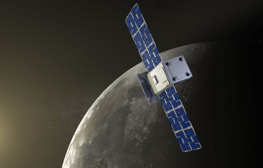
Advanced Space has announced updates since the Cislunar Autonomous Positioning System Technology Operations and Navigation Experiment (CAPSTONE) was launched last year. The company said it was able to demonstrate spacecraft-to-spacecraft navigation technology called the Cislunar Autonomous Positioning System (CAPS).
Not everything was great. Last July, after CAPSTONE separated from its launch vehicle, it went silent. Two days later, the company determined what caused the problem, a thruster anomaly, and recovered communications with the spacecraft.
By successfully sending a signal to the Lunar Reconnaissance Orbiter and receiving it back, the company said CAPSTONE processed measurements computed from the signal to determine the position and velocity of both spacecraft. The company said the shared information can serve a purpose like GPS for spacecraft and surface vehicles at the Moon.
As part of CAPSTONE's technology demonstrations, the spacecraft is equipped with a Chip Scale Atomic Clock (CSAC) to demonstrate one-way, uplink navigation, the company said. The precise timing of the CSAC is used in conjunction with an uplink signal on the ground to compute range and Doppler measurements on the spacecraft as part of the CAPS navigation technology to estimate the spacecraft's state, the company said.
Contact: Caitlin Davis, Advanced Space, caitlin@commodditiesinc.com, https://advancedspace.com.
Get smarter in 5 minutes with Morning Brew (it's free)
There's a reason over 4 million people start their day with Morning Brew - the daily email that delivers the latest news from Wall Street to Silicon Valley. Business news doesn't have to be boring...make your mornings more enjoyable, for free.
Other Location News:
News tip? Send them to kdennehy@driverlessreport.com. Go to www.locationbusinessnews.com for more news and an archive of stories.
Top News:
⚡ CMT Says: You're a Bad Driver. Roger Lanctot’s take on the burgeoning insurance telematics market.
🤨 CalAmp 1Q Revenue Falls, Hit by Telematics Products Unit. “CalAmp CAMP 0.00%↑ on Monday reported a narrower loss in the fiscal first quarter, but revenue declined hit by its telematics products business.”
✔ U-Blox Reports First Half 2023 Revenue Growth of 13% Compared to the Prior Year Period.
🛰 PE Firms, Defense Companies Vie for Ball Corp's Aerospace Unit. “Private equity firms Blackstone BX 0.00%↑ and Veritas Capital Fund Management are competing against large defense companies to acquire the aerospace business of Ball Corp. BALL 0.00%↑.”
Maps:
😥 Google Exec Suggests Instagram and TikTok Are Eating Into Google's Core Products, Search and Maps. “Core Google GOOG 0.00%↑ services, including Search and Maps, are also being impacted by a growing preference for social media and videos as the first stop on younger users’ path to discovery.”
👍 Mapping How AI, Graph and Location Technology Trends Are Converging in 2023 and Beyond. “As geolocation usage expands, so do the adjacent technologies that are both benefiting from and enhancing spatial data.”
🤞 Looking for a Google Maps Alternative? This Android Auto App Will Soon Get New Features. “OsmAnd is a top choice, using the OpenStreetMap (OSM) map database for accurate directions and up-to-date information.”
🙂 California State Parks Introduces what3words Tool. “A new tool in the State Parks toolkit, what3words provides dispatchers with state-of-the-art technology to assist visitors in the event they become lost, stranded or who otherwise need help from emergency services.”
😐 It's Time to Install Waze: You'd Better Not Use This Google Maps Feature Anymore. “After a recent update, some Google Maps for Android users noticed rather unusual behavior in the application. The alternate routes displayed by the app come with ridiculously faster times, sometimes much higher than the current ETA to the destination.”
👏 OGC Compliance Certification Available.
Reach nearly 14,000 subscribers and 70,000 more via social media by advertising in Location Business News!
We can promote your webinar, service or product to a focused group of industry executives. Email us at info@driverlessreport.com for more information, or click here to view our one-page media kit.
Connected and Autonomous Vehicles:
😲 Robotaxi Haters in San Francisco Are Disabling the AVs With Traffic Cones. “A decentralized group of safe streets activists in San Francisco realized they can disable Cruise and Waymo robotaxis by placing a traffic cone on a vehicle’s hood, and they’re encouraging others to do it, too.”
☹ San Francisco Residents Say They Can’t Sleep Due to Circling Robotaxis. “But despite repeated requests to the driverless car operator over the past three months, the Cruise robot cars' demented doom loops have continued to disturb her and her neighbors' sleep for six straight weeks.”
😕 The Latest Autonomous Technologies Are Already Outdated. “If Mercedes can get Level 3 certification with yesterday’s technologies today, what will its car designers be able to do with today’s technologies tomorrow?”
🚗 Volkswagen Will Start Testing Self-Driving Cars in Austin as It Moves on From Argo AI. “It will deploy about 10 of its ID Buzz electric vans equipped with autonomous-driving systems developed with Mobileye by the end of 2023.”
Other Stuff:
🤔 Sunlight Polarization Patterns May Be an Underwater Substitute for GPS. “A University of Illinois team led by professors Viktor Gruev and David Forsyth started out by taking approximately 10 million photographs with an underwater camera that was equipped with a special lens.”
Engaging Short-Form Video for B2B SaaS
Spacebar Visuals creates engaging short-form videos for B2B SaaS companies by turning your written content, such as blog posts, eBooks, surveys and more into engaging video content to drive top- and mid-funnel lead gen.
Location Industry Briefs
Send your news releases to kdennehy@driverlessreport.com. Go to www.locationbusinessnews.com for more news and an archive of stories.
Telit Cinterion To Sell Its Cellular Automotive Module Unit to Kontron
Telit Cinterion will sell its cellular automotive IoT product business to Kontron AG [KTN], concentrating on industrial and commercial IoT markets. The transaction includes Telit Cinterion's complete portfolio of cellular automotive wireless communication modules, ranging from 4G LTE to 5G. The companies did not divulge financial details.
Contact: Leslie Hart, Telit Cinterion, (919) 415-1510, leslie.hart@telit.com.
U-blox Module Earns Certification on KT’s LTE-M Network
Thalwil, Switzerland-based u-blox [UBXN] has announced the certification of its SARA-R510M8S module on the LTE-M network of South Korean telecom giant KT. The module is 5G-ready and targeted to LPWA IoT applications, such as industrial automation, sensor applications, connected health, metering, asset and vehicle tracking, as well as telematics, the company said.
The module is Microsoft Azure certified and AWS IoT Core qualified, the company said.
Contact: Natacha Seitz, u-blox, 41 76 436 0788, natacha.seitz@u-blox.com, www.u-blox.com.
Borderless Capital Leads $1.5M Investment Into the Geodnet Foundation To Support Location Service
The GEODNET Foundation has announced a private $1.5M token sale round led by Borderless Capital’s EdgeFi Fund, with participation from IoTeX. With more than 3000 reference stations online in every continent, the GEODNET network is the world’s largest decentralized Geo-Spatial Reference Network, the company said. The GEODNET location service offers centimeter location accuracy for such applications as drones, robotic vehicles, augmented reality and IoT/mobile devices.
Contact: GEODNET, info@geodnet.com, https://geodnet.com.
Advanced Navigation Launches Boreas A Series
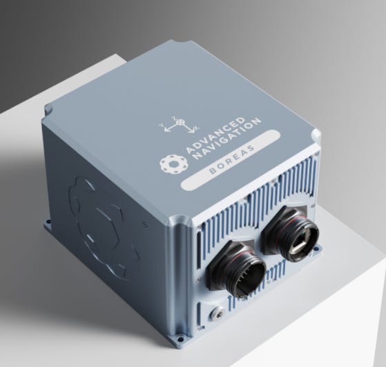
Advanced Navigation has announced the expansion of its Boreas digital fiber-optic gyroscope (DFOG) range, with the new A Series. The Boreas A90 and A70 are inertial measurement units (IMU) that feature automatic gyrocompassing, the company said.
The new series features reductions in size, weight, power and cost, the company said. The Boreas range is targeted to marine, surveying, subsea, aerospace, robotics and space markets.
Contact: Stephanie Qiu, Advanced Navigation, stephanie.qiu@advancednavigation.com, www.advancednavigation.com
Tive Announces New Capabilities For Location Products
Boston-based Tive has announced its customers can now gain an end-to-end view into the location and condition of their shipments, regardless of the mode of transportation, with new features on its Solo 5G trackers, cloud-based platform, and an open API. Tive customers can now enter air waybill numbers directly into its platform to gain access to the location of their freight. Customers using Tive for ocean tracking can now tap into GPS coordinates provided by a vessel's Automated Identification System.
Contact: Charlie Pesti, Tive, media@tive.com, www.tive.com.
Quectel Rolls Out 4G/5G, LPWA and GNSS Antennas
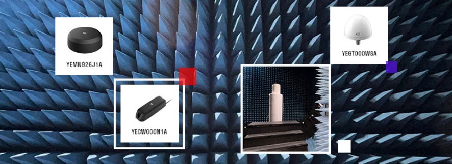
Quectel Wireless Solutions has launched the YEMN926J1A 5G and YECW000N1A low power wide area (LPWA) antennas. The company also launched the YEGT000W8A GNSS L1 and L5 antenna.
The YEGT000W8A GNSS antenna supports the 1164-1189MHz and 1559-1606MHz frequency bands. With dimensions of 65mm x 45mm, the GNSS antenna is RoHS and IP67 compliant, the company said.
Contact: Quectel Wireless Solutions, www.quectel.com.
Iteris Wins $1.3 Million Contract
Iteris ITI 0.00%↑ has signed a three-year SaaS agreement with the Los Angeles County Metropolitan Transportation Authority to use its ClearGuide to enable analysis of traffic data. The deal calls for LA Metro to have access to ClearGuide, including bottleneck detection and alerts, dynamic maps to support detailed traffic analysis and other tools. ClearGuide is part of Iteris’ ClearMobility Platform, which monitors, visualizes and optimizes mobility infrastructure, the company said.
Contact: Breanna Wallace, Iteris, (949) 996-5348, brwallace@iteris.com, www.iteris.com.
Kudelski Grabs DIU Contract
Kudelski IoT [KUD.S] has announced that it has been selected by the U.S. Department of Defense's Defense Innovation Unit (DIU) to pilot an asset tracking solution for Aerospace Ground Equipment (AGE). Kudelski IoT's RecovR asset tracking solution has been adopted by car dealerships across North America since its launch in 2021, the company said. Leveraging its expertise in IoT security, Kudelski IoT has deployed its solution for the DIU at a USAF base, providing real-time location data
Contact: Cédric Alber, Kudelski Group, (415) 962-5005, cedric.alber@nagra.com, www.kudelski-iot.com.
Liebherr Expanding Leica Geosystems’ Machine Control Systems
Liebherr, with Hexagon’s Leica Geosystems, offers machine control systems for hydraulic excavators ex works. Liebherr is now extending its range of machine control systems for its Generation 8 crawler excavator models.
Leica Geosystems' machine control systems are available in different versions for Liebherr mobile and crawler excavators, the company said. They include the 2D passive and 3D passive machine control system for Generation 6 and 8, as well as the 2D "3D-ready" semi-automatic and the 3D semi-automatic for Generation 6, the company said.
Contact: Reka Vasszi, Leica Geosystems AG, reka.vasszi@hexagon.com, leica-geosystems.com.
Spire Extends Tracking Agreement With OceanMind
Spire Global $SPIR has extended its agreement with OceanMind to provide real-time automatic identification system (AIS) vessel-tracking data. Spire has been providing AIS data to OceanMind since 2019, the company said. By integrating Spire’s suite of AIS solutions, OceanMind identifies suspected illegal fishing globally and delivers actionable insights to enforcement officials, the company said.
Contact: Sarah Freeman, Spire, sarah.freeman@spire.com.
ProStar Holdings Announces Private Placement
ProStar Holdings has announced a non-brokered private placement for gross proceeds of as much as $2.5 million. The offering will consist of as many as 8,333,333 shares of stock at 30 cents per share, the company said. The company said it would use the proceeds for sales, marketing, research and development.
Contact: Joel Sutherland, ProStar, (970) 822-4792, investorrelations@prostarcorp.com, www.prostarcorp.com.
Create a FREE ManyMe Account.
Mobilicom Grabs Order from U.S. Tier-1 Drone Manufacturer
Mobilicom Limited MOB 0.00%↑ said it has received a purchase order from Teledyne-FLIR TDY 0.00%↑ for 120 of its SkyHopper PRO datalink systems. SkyHopper PRO systems will be integrated into small-sized drones manufactured for the U.S. Department of Defense. Delivery of the SkyHopper PRO systems is expected later this year.
Delivery of the SkyHopper PRO systems is expected later this year. SkyHopper PRO is designed for commercial and industrial drones, enabling fleet management and operation of autonomous uncrewed autonomous vehicle (UAV) systems, the company said.
Contact: Liad Gelfer, Mobilicom, liad.gelfer@mobilicom.com, www.mobilicom.com.
Topcon Introduces Aptix
Topcon Positioning Systems has introduced Aptix, an integration-platform-as-a-service (iPaaS) to optimize how heavy civil construction projects are managed. Aptix integrates Topcon solutions with multiple third-party applications to automate and orchestrate data connections between the office and job site.
Aptix shows, in near real-time, the location of machines with the ability to aggregate as-built data from mixed fleet telematics, the company said.
Contact: Beth Emmert, Topcon Positioning Systems, (925) 505-4434
bemmert@topcon.com, topconpositioning.com.
Murata Partners With MobileKnowledge
Murata has announced a partnership with MobileKnowledge to integrate MK UWB kits. The MK UWB Kit RTLS supports the deployment of indoor location systems using Time Difference of Arrival (TDOA). The combined UWB and Bluetooth LE capabilities of Type 2DK make it ideal for location tags, such as personal and asset trackers, the company said.
Contact: MobileKnowledge, www.themobileknowledge.com/products.
Vueron Names Cognata as AV Simulation Provider
Lidar perception software provider Vueron said Cognata will provide its ADAS and autonomous vehicle simulation. The companies say the deal will expedite development and validation of perception algorithms for autonomous driving systems.

The deal allows Vueron to gain access to Cognata's ADAS and AV simulation software. Vueron said it has validated the data under various environmental conditions.
Contact: Shay Rootman, Cognata, shay@cognata.com, www.cognata.com.
Litum Forklift Solution Added to Parts Program
Real-time location systems provider Litum has announced its forklift safety solution will now be included in the UNISOURCE Parts and Accessories program offered by authorized Hyster and Yale dealers. Litum's forklift safety solution, the Proximity Detection System, offers safety features designed to help increase both operator and pedestrian awareness to alert or detect workplace obstacles, the company said.
Contact: Dilge Imer, Litum, 905386810440, media@litum.com, www.litum.com.
Airspace Link Rolls Out Developer Tools
Airspace Link has announced a set of drone developer tools designed to allow third parties to interface with AirHub API. The AirHub API enables partners to streamline operator workflows, the company said. The API enhance AirHub API services that provide community and national hazards, risk analytics, routing and more to native drone applications, the company said.
Contact: Airspace Link, hello@airspacelink.com, www.airspacelink.com.
If you're a student in the US looking for a better way to pay for higher education, Bold provides thousands of students with $25k scholarships every year. Enter to win one of our monthly $25,000 scholarship to go towards your tuition, student loan debt, or other education related expenses!
Apply to a Bold scholarship today
People
Telit Cinterion has announced the appointment of Sashidhar Thothadri as chief commercial officer and Neset Yalcinkaya as senior vice president sales, Americas.
Korem has named Christophe Charpentier as company president. Korem said the new president’s main mission is to accelerate growth in the United States, which constitutes 55 percent of its sales.
Teledyne Geospatial has appointed Geoffroy Deltel as vice president and general manager. Deltel will replace Michel Stanier who is moving to an executive business development role within the larger Teledyne Digital Imaging segment.

Taoglas CEO Dermot O’Shea has been inducted into the SETU New Frontiers’ entrepreneurial hall of fame. O’Shea’s inclusion is in recognition of his achievements in growing Taoglas to a more than $100-million business and employing 500 people in 10 global locations, the organization said.
PreAct Technologies has named Suresh Subramani as vice president, program management and product planning.
Vehicle tracking company Quartix Technologies has announced that CTO Laura Seffino has resigned from the company's board in order to focus on delivery of its technology roadmap.
Phunware PHUN 0.00%↑ made a 600,000-share “inducement grant” to Troy Reisner, the company’s new CFO.
Jobs
Director Business Development, Enterprise North America. Parkopedia.
Product Marketing Manager. TomTom.
Senior Product Manager, Automotive. Swift Navigation.
Global Sales Director. Trimble.
Sales Manager GNSS BENELUX. Septentrio.
Aviation Marketing Manager 1. Garmin.
Click HERE to Join our growing Location Business News LinkedIn Group!


