


FCC Gives OK to Explore Complementary GPS Tech
For Paid Subscribers: Plus California gets tough on location data companies, plus Japan introduces drone/autonomous vehicle corridors, Jobs and People.

Fleetio Acquires Auto Integrate to Grow to a $1.5 Billion Company
In an acquisition that grows its business to a behemoth worth more than $1.5 billion, fleet management company Fleetio has acquired Auto Integrate. In addition, Fleetio announced the closing of $450 million funding round that will help to finance the acquisition.
The combined entity will serve more than 8 million vehicles and process 13 million repair orders through a network of 110,000 repair shops in the United States, Canada and Mexico. Auto Integrate, a maintenance authorization platform, and Fleetio have had a business relationship since 2019.
The funding round was co-led by existing Fleetio investor Elephant and new investor Growth Equity at Goldman Sachs Alternatives.

"This acquisition is transformative for our ability to equip customers with the simplest and most efficient solution for fleet maintenance and management," said Jon Meachin, CEO of Fleetio. "By bringing together Fleetio's comprehensive fleet optimization capabilities with Auto Integrate's specialized maintenance authorization network, we're creating a truly customer-focused, end-to-end solution that addresses the most critical pain points fleet operators face today.”
“Bringing Fleetio and Auto Integrate together is a game-changer for both fleets and repair shops, ensuring a seamless, more connected maintenance experience,” said Tony Summerville, Fleetio founder and board chair, in a statement. “Whether a shop does a little or a lot of fleet business, this combination eliminates friction and makes it easier than ever for shops to work with more fleets.”
Fleetio, which was founded in 2012 and offers its services to more than 7,500 public and private fleets in 100 countries, has partnered with some industry giants in the past year. In 2024, Fleetio and Ford Pro announce an expanded connected fleet integration, partnered with fleet telematics company Razor Tracking, and integrated data management with Lytx. The company also expanded its Geotab integration with Shop Network Add-In for maintenance management.
Fleetio, also in 2024, announced it had installed its fleet optimization platform in 1 million vehicles worldwide. At the same time, the company announced that it grew to more than 1.3 million Fleetio Go mobile app users.
Visual Navigation for Robots: Out of Stealth Tera AI Raises $7.8 Million
Coming out of stealth, Tera AI has announced that it has raised $7.8 million in a seed round to develop software known as zero-shot navigation for autonomous hardware-like robots. The funding, co-led by Felicis and Inovia Capital, includes participation from Caltech + Wilson Hill, and Naval Ravikant.
San Francisco-based Tera AI was founded by Tony Zhang, who previously led machine learning at Google X, and now serves as company CEL. Tera AI has a team of AI and simulation researchers from Google AI, Caltech, MIT, and the European Space Agency.

"Spatial reasoning is one of those innate skills humans have that's really underappreciated and missing in foundation models today," Zhang said. "Most robots today lack the ability to move between physical environments, and 99 percent of autonomous systems use little to no AI for navigation. Humans can easily navigate between indoor and outdoor places with just our eyes.”
Zhang said people’s brains passively builds internal models of the outside world, which they can reuse years later to recognize exactly where we are. “We can read a map we've never seen and use it to navigate a maze-like indoor space. At Tera AI, we believe zero-shot navigation for robots is a problem that software-alone can solve,” he said.
Tera said it will use the funding to deploy an initial solution into embedded devices later this year and will be growing the technical team across both product and research.
Zhang told TechCrunch that new capabilities for existing robots in autonomy will be more affordable with Tera AI’s solution. Localization sensors, lidar system, a pricey Inertial Measurement Unit or even a high-precision GPS receiver can be cost prohibitive for a lighter robot that costs less than $50,000.

Are you ready for your next Trade Show? JB Media is your one-stop shop for printing, promotional products and corporate wearables. Let us help you prepare for your next show! Visit our website, e-mail us at Service@JimBrownMedia.com or call us direct at (720) 588-0493.
Google Eliminates 10,000 Fake Listings from Google Maps, Users Lose Travel History
Google GOOG 0.00%↑ said last week it was taking down 10,000 phony listings from Google Maps and seeking legal action against entities that created them. According to CBS News, a scam network created false profiles on Google Maps and sold them.
Scammers have been sophisticated in their use of Google Maps. They provide phony reviews, have victims contact a call center who try to sell them fake services and products, and even provide a service at a higher charge. The CBS News report said that it removed or blocked more than 12 million fake business profiles two years ago.

In other Google Maps news, users have been complaining on Reddit that their timeline data has disappeared, according to a The Verge story. Google said it accidently deleted the data—and those not using its cloud backup could not recover any of it, the story said. The Timeline feature on Google Maps tracks users’ location history, allowing them to see where they were on trips and other travel information.
The company, last summer, said they were switching to on-device storage for Google Maps location data. According to The Verge, Google allowed users to keep track of their Maps location history without having it tracked on the parent company’s servers for privacy.
Weekly Location Industry News
News tip? Send them to kdennehy@driverlessreport.com. Go to www.locationbusinessnews.com for more news. Location Business News is looking for your company’s news, products and use cases to feature in each issue.
Top News:
😕 Launch Delays Hamper Near-Term Impact of GPS Experimentation Program. “The [U.S. Space Force] planned to launch the Navigation Technology Satellite-3 demonstration, dubbed NTS-3, in 2022 with an eye toward experimenting with new PNT signals and payloads that could be installed on future GPS satellites and shape its long-term plans for the constellation. The satellite’s development, led by the Air Force Research Lab and L3Harris, has proceeded on schedule, but delays to the rocket assigned to fly the spacecraft — United Launch Alliance’s new Vulcan Centaur — have stalled the program for years. The mission is slated to fly on Vulcan’s first national security launch this year, but those plans are on hold as the company awaits final certification from the Space Force.”
💰 Sateliot Closes $75 Million Series B Round with $10.7 Million from Hyperion. In a big step to deliver 5G/IoT connectivity from space, Sateliot closes a $75 million B Round, with $14.8 coming from the Spanish government.
🌎 Protection of the Radio Navigation Satellite Service from Harmful Interference. Three international organizations, the International Telecommunications Union (ITU), International Maritime Organization (IMO) and International Civil Aviation Organization (ICAO) issued a plea for the protection of radio navigation satellite service from interference.
🛩 No Signal, No Problem: Intelligence Firm Debuts Drone Tech Equipped to Beat GPS Jammers. “The war between Russia and Ukraine presented a unique problem: each military had learned how to jam the other's GPS signals, meaning their drones would be flying blind. Maxar has the capability to counter GPS-jamming technology through its Raptor system.”
☹ Are Israel’s GPS Attacks Impacting India As It Records 465 Incidents Of “GPS Spoofing” In Last 15 Months? “India recorded 465 incidents of interference with aircraft navigation systems between November 2023 and February 2025, mostly in the border regions of Amritsar and Jammu, both near the Pakistan border.”

Expert nationwide installation services for fleet technologies.
Maps:
📲 Apple Says It'll Use Apple Maps Look Around Photos to Train AI. “Starting in March 2025, Apple AAPL 0.00%↑ will use blurred imagery captured during Apple Maps surveys to improve other services.”
🤷♂️ ChatGPT Just Got New Mapping Features, But They Don't Work Very Well Yet. “I used ChatGPT Deep Research to plan museum visits in Tokyo. As detailed as that report might have been, however, it missed a critical piece of information: the map. OpenAI doesn’t have its own mapping service, so it can’t place those points of interest on a map. I still used Google Maps to plan my days based on the ChatGPT Deep Research report.”
🖐Android Auto Users Confused Over the Google Maps Feature Many People Hate. “The ability to report incidents in Google Maps on Android Auto is powered by a hazard icon appearing on the screen when navigation is enabled. However, this icon doesn't appear on the screen for all users running Android Auto, and many believe this is because Google GOOG 0.00%↑ hasn't enabled the feature for everybody.”
😦 Apple Maps Bug Randomly Showing Airport Baggage Claim PINs. “A strange Apple Maps bug is showing point-of-interest pins for a smattering of airport baggage claim stations across the United States, while the map is zoomed far way enough that otherwise almost no landmarks, let alone airports, are marked.”

✈ Mappedin Directory for Airports. The directory allows passengers to look up flight status, find deals and events, get directions and browse in different languages.
🙂 Google Maps Is Getting More Specific About Route Overviews. “Beyond these tweaks, Google Maps is also getting Gemini-fied. An upcoming integration will let you ask Google’s Gemini AI contextual questions about a place you’ve opened within Maps.”
😐 LandsD's 3D Digital Maps Achieves Territory-Wide Coverage
🗺 Most Taxi Drivers Use Google Maps, Waze Not Even in Second Place. “The 2024/25 National Taxi and Private Hire Driver Survey [in the United Kingdom] revealed some unexpected numbers, especially as more taxi drivers embrace technology to plan their routes and find a faster way to arrive at the address requested by the customer. The survey highlighted an important change in trends. While most taxi drivers used to rely on their experience to find a faster route to a destination and avoid heavy traffic and slowdowns, 68.7% of the drivers now claim they rely on satnav for the same purpose.”
Editor’s Note: Only 68.7 rely on satnav in the UK?

Become a Paid Subscriber to Location Business News! Only $8 per month!
What Paid Subscribers get:
Full access to more than 200 Archived issues (stories, contacts, analysis).
A new subscriber-only Chat Board.
Access to Analysis and In-Depth Articles, plus People and Jobs.
Free entry to LBN-branded webinars and receptions at major trade shows (in development).
Steep Advertising Discounts for paid subscribers and Founding Members.
We average 30,000 views on our websites each month. Advertising starts at only $150 per issue. Please contact us at info@driverlessreport.com for more information…or go to our updated Advertising Page.
Connected and Autonomous Vehicles:
👍 Caterpillar Taps Luminar's Lidar for Self-Driving Construction Equipment. “Caterpillar CAT 0.00%↑ is adding lidar to its heavy-duty construction equipment after striking a deal with Luminar LAZR 0.00%↑ which makes the laser sensor for a number of automakers and self-driving car operators. Caterpillar says it will integrate Luminar’s hardware into its Cat Command autonomy platform, which it uses to power self-driving features in its trucks and other vehicles.”
👉 Everyone's Missing the Point of the Tesla Vision vs. Lidar Wile E Coyote Video. “It was essentially a comparison test between Tesla’s TSLA 0.00%↑ camera-only autopilot/FSD system and lidar systems, with the lidar vehicle running Luminar’s LAZR 0.00%↑ system. The test results showed the lidar doing better overall, primarily due to its better performance in fog and rain. For more realistic light fog or lighter rain, the cameras likely would have fared better.”
🚕 Lyft to Roll out Robotaxis in Atlanta. “The ride-hailing company said last week that users will be able to take rides in self-driving cars starting this summer, with autonomous vehicles first hitting the streets of Atlanta. The rollout will be done in partnership with May Mobility.”
🤨 Waymo Plans Robotaxi Launch in Washington, DC in 2026. “But it will need to change the law prohibiting fully driverless vehicles first.”
🚘 Waymo to Begin Testing Autonomous Vehicles in Nashville. This week…
🙄 Tesla's Self-Driving Dreams Hit a Wall in China--But a Comeback Is Already Brewing. “Tesla TSLA 0.00%↑ is inching closer to launching its Full Self-Driving (FSD) software in China but not without navigating a fresh wave of regulatory hurdles.”
🤔 Zoox CTO: Why Self-Driving Cars Are So Hard to Get Right. “Zoox agreed to recall the software on 258 vehicles due to unexpected braking issues following two accidents involving its test vehicles in May 2024, according to Reuters and the National Highway Traffic Safety Administration.”
👉 Former Cruise CEO Vogt's Robotics Startup Valued at $2 Billion in New Funding. “It reflects investors' confidence in a company that has yet to release its product and has no revenue, as the appeal lies in the potential of robotics powered by AI models that can learn to do new tasks, which have captured Silicon Valley's imagination.”
🌍 UAE Emerging as a Leader in Autonomous Vehicle Innovation, Says Arthur D. Little. “Dubai and Abu Dhabi, especially, have worked to become testing grounds for autonomous vehicle technology.”
👌 Nexar Teams with NVIDIA to Advance Autonomous Vehicle Innovation. “Nexar has partnered with NVIDIA NVDA 0.00%↑ aimed at transforming the automotive landscape to combine NVIDIA's AI and computing capabilities to help process Nexar's vision data.”
Fleet Telematics:
🚍 Platform Science Partners with MapUp for Fleet Toll Management. “Platform Science has announced a partnership with MapUp to integrate MapUp's suite of toll management products with Platform Science's telematics capabilities. This integration leverages real-time GPS tracking and dispatch data to provide insights into toll costs and route optimization.”
🚚 Azuga Celebrates Two-Year Membership with the IoT Observatory.
🚛 New SKF and Samsara Fleet Safety Partnership. “SKF Automotive announced a new partnership with Samsara IOT 0.00%↑ to deliver an integrated bearing safety solution.”
Financial:
😕 Trimble Gets Nasdaq Non-Compliance Letter Over Delayed Annual Report Filing.
✔ Intermap Announces 2024 Results and 2025 Guidance.
💲 Runnymede Capital Advisors Takes $441,000 Position in Samsara.
✔ STMicroelectronics Announces Status of Common Share Repurchase Program.
😐 Urgently Notified By Nasdaq Of Non-Compliance With Nasdaq’s Continued Listing Standards.

The D-Day Visitor's Handbook: Your Guide to the Normandy Battlefields and WWII Paris by Kevin Dennehy and Steve Powers. The guidebook uses location technology from what3words to locate monuments, museums and other attractions. Get your guidebook today.
Weekly Product News
Send your news releases to kdennehy@driverlessreport.com. Go to www.locationbusinessnews.com for more news and an archive of stories.
JAXA Selects Spirent’s PNT Simulation Solution to Support Lunar Navigation Program
Spirent Communications has announced that the Japan Aerospace Exploration Agency (JAXA) has selected the company to provide a lunar PNT simulation solution. The pioneering technology will support JAXA’s lunar exploration initiatives and contribute to the development of critical navigation infrastructure for future missions on the Moon, the company said. Spirent’s said its PNT X solution enables JAXA to simulate lunar PNT services in before they become operational on the Moon—in compliance with the emergent LunaNet specification.
Contact: Sherri Walkenhorst, for Spirent, (801) 373-7888,
sherriw@connectmarketing.com.
TomTom Extends Collaboration With Sumitomo Electric
TomTom [TOM2] is extending its collaboration with Sumitomo Electric. The companies will offer a traffic light optimization solution powered by TomTom’s technologies, though the companies did not reveal who is doing what.

In other TomTom news, the company and UK-based fleet technology provider CMS SupaTrak have partnered to use TomTom’s SDK to integrate turn-by-turn navigation into SupaTrak’s JobTrak Route Management solution. TomTom said the integrated solution helps customers optimize their routes, reduce fuel costs, lower emissions, and improve driver behavior.
Drone Nerds Partners With Wingtra for Aerial Surveying and Mapping
Drone Nerds has partnered with Wingtra, the Swiss-based producer of the WingtraOne GEN II mapping drone. The companies will offer aerial surveying and mapping capabilities for customers in urban planning, mining, construction, agriculture, and environmental monitoring markets. Drone Nerds will integrate WingtraOne GEN II drones into its service offerings, the company said.
Contact: Cara Ferreira, Drone Nerds, (786) 708-7809, caraf@dronenerds.com, www.enterprise.dronenerds.com.
Inertial Labs Unveils Anti-Jamming CRPA System for Assured Navigation
Inertial Labs, now owned by VIAVI Solutions $VIAV has launched its M-AJ-QUATRO anti-jamming antenna system. The solution is equipped with Controlled Reception Pattern Antenna (CRPA) and digital processing technologies, the company said.

The M-AJ-QUATRO operates across L1, L2, and L5 GNSS bands, has adaptive digital nulling, and suppresses jamming signals with over 34dB+ interference suppression (export-free version) and over 45dB+ interference suppression (export-controlled version), the company said.
Contact: Emma Jenkins, for Inertial Labs, (415) 800-4529, emma@grandbridges.com.
Topcon Positioning Systems Offering New Products at Bauma 2025
Topcon Positioning Systems will exhibit new products at the Bauma 2025 construction show, April 7-13, in Munich, Germany. Topcon’s stand will feature its MC-Max excavator system with Layout Navigator.

Other Topcon products to be displayed include its new HiPer XR GNSS receiver, Tierra telematics and fleet management solutions. The company will also display GNSS correction services for survey and mapping through its Topnet Live.
Contact: Staci Fitzgerald, Topcon Positioning Systems, (925) 245-8610, corpcomm@topcon.com, www.topconpositioning.com.

Create a FREE ManyMe Account.
Suntech GPS Tracker Certified by Carriers
Suntech International USA has announced that its ST6560 GPS Tracker is certified on AT&T T 0.00%↑, T-Mobile TMUS 0.00%↑, and Verizon VZ 0.00%↑ for IoT real-time vehicle and fleet management.
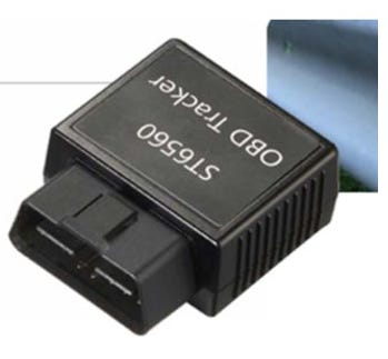
Key features include GPS with dead reckoning support, advanced telematics standard OBD, Bluetooth gateway, monitor and motion sensors and battery backup. The company says the tracker has LTE Cat M1 and NB2-IoT compatibility.
Contact: Suntech International USA, info@suntechus.com, www.suntechus.com.
Garmin G3000 PRIME Selected for Military Training Aircraft
Garmin GRMN 0.00%↑ has announced its G3000 PRIME tandem integrated flight deck has been selected by Pilatus for its PC-7 MKX military training aircraft. G3000 PRIME will integrate with three third-party custom user-defined cockpit displays to provide a Primary Flight Display (PFD), Multi-Function Display (MFD) and Engine Indication System (EIS) display, the company said.

The Runway Occupancy Awareness (ROA) feature analyzes GPS and ADS-B traffic information relevant to the airport's runways and taxiways to assess and alert the flight crew of a possible runway incursion or collision, the company said.
Contact: Mikayla Minnick, Garmin, (913) 397-8200, media.relations@garmin.com, www.garmin.com.
3D-Printed, Kamikaze Drone Completes Flight
Cummings Aerospace's Hellhound S3, a turbojet-powered, 3D-printed kamikaze drone that flies faster than 375 mph, completed a demonstration at the Army Expeditionary Warrior Experiment (AEWE) 2025. Hellhound S3 is an unmanned aircraft system (UAS) designed to equip the U.S. Army's Infantry Brigade Combat Teams (IBCTs) with the same combat power as armored brigades, the company said.

The demonstration included one GPS-guided tactical mission using an inert warhead payload, the company said. The system, which weighs less than 25 pounds, allows a single soldier to carry.
Contact: Cummings Aerospace, https://cummingsaerospace.com.

Click HERE to Join our growing Location Business News LinkedIn Group!
FCC Gives OK to Explore Complementary GPS Tech
In a bipartisan vote, the Federal Communications Commission today officially launched an inquiry to explore commercial technologies that would complement GPS.
(See below for paid subscriber content, including Japan’s drone/autonomous vehicle corridor, California’s crackdown on location data, plus Jobs and People).
Keep reading with a 7-day free trial
Subscribe to Location Business News to keep reading this post and get 7 days of free access to the full post archives.