


FCC to Explore GPS Alternatives
U.S. agency will vote on March 27 to explore PNT systems that can compliment or be an alternative to GPS. Paid subscriber content below, plus u-blox's big 2024 losses, INRIX moving, People/Jobs.

Mobile World Congress 2025: Location Technology Enabler for 5G, IoT and Auto Industry
While artificial intelligence, for the second year in a row, dominated many sessions at Mobile World Congress in Barcelona this week, location technology as an enabler for asset tracking, connected and autonomous vehicles seemed to be gaining pre-pandemic traction.
One company, Samsung subsidiary HARMAN, launched Ready Aware at MWC Barcelona 2025. Ready Aware is a vehicle-to-cloud software service that provides in-vehicle contextual alerts to to improve a driver’s situational awareness at intersections and around a variety of road hazards, the company said. Marketed to OEMs, Ready Aware is available in North America, Europe, and India.

At MWC, HARMAN and HERE Technologies announced that they are developing direct and cloud-based vehicle-to-everything (V2X) driver assistance systems that can support automotive OEM’s compliance with Euro NCAP 2026 driver assistance programs. The joint offering’s road alerts will provide advanced alerts for accidents, stationary vehicles, and wrong-way drivers, the company said.
Swift Navigation CEO Tim Harris was on a panel at MWC with Deutsche Telekom and Ericsson to discuss how 5GAA and precise GNSS are advancing autonomy. The companies say safe autonomy requires centimeter-level positioning. The companies are integrating RTK GNSS on Ericsson’s 5G routers for transportation, logistics, and heavy machinery markets.
Overall, MWC organizers said the numbers looked good for this year’s show: 109,000 attendees from 205 countries and territories, more than 2,900 exhibitors, sponsors, and partners, and 1,200 speakers.
In other MWC 2025 news:
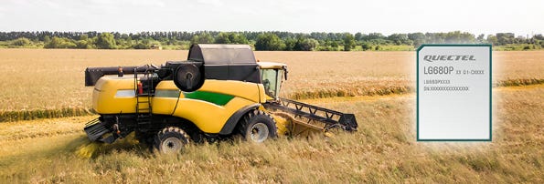
Quectel Wireless Solutions launched its LG680P, a quad-band GNSS module for precision agriculture, intelligent robots and surveying. The Quectel LG680P GNSS module can receive signals from GPS, GLONASS, Galileo, BeiDou (BDS), QZSS, and NavIC. With multi-band GNSS support, it concurrently receives L1, L2, and L5 bands.
Combain Mobile exhibited at the show and announced that their API was available on the AWS Marketplace. The company said the announcement allows businesses to acquire real-time location tracking, IoT and smart devices for connected solutions and asset and fleet management products for indoor and outdoor tracking.
Fibocom has launched its MQ780-GL Category M module embedded with the Qualcomm QCOM 0.00%↑ E51 4G Modem-RF. MQ780-GL looks to drive adoption of LPWA technologies’ applications including smart metering, asset tracking, and smart cities, the company said. For location-based services, the module includes Soft GPS for asset tracking.

SATELLAI Tracker (SATELLAI). SATELLAI made its European debut at MWC 2025 with the launch of the SATELLAI Tracker, which is designed for pet owners who explore off-the-grid locations. Equipped with the Qualcomm 9205S Modem, SATELLAI Tracker, available for purchase in June, features GNSS and connects through 680 networks in 180 countries.
Telit Cinterion rolled out the FE990D and FN990D AI-powered 5G modules and data cards featuring the Qualcomm X85/X82 5G Modem-RF. Both products integrate Qualcomm’s 5G solution to enhance traffic prioritization, optimize energy efficiency, reduce latency and improve location accuracy, the company said.

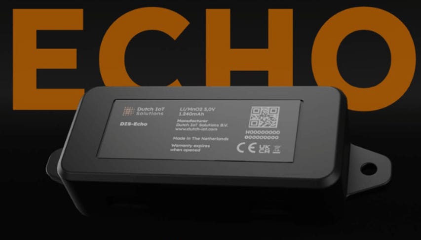
Dutch IoT Solutions’ DIS-Echo IoT tracker (Dutch IoT Solutions). Dutch IoT Solutions displayed its DIS-Echo, which combines high-frequency beaconing with Sigfox 0G connectivity. The company says the solutions enables businesses to track valuable assets with their own facilities or across “vast supply chains.”
The Automotive Edge Computing Consortium (AECC) showcased four auto use cases in a demonstration area, including telematics solutions from Soracom and Toyota for cloud connectivity for connected vehicles.
AntennaWare and Truesense have partnered to launch the TSRB040 module, a body-wearable UWB device. The module enhances reliability and accuracy in proximity-based applications and RTLS systems, the company said. The module also allows for real-time tracking, secure authentication, and precise localization in environments where traditional UWB solutions struggle due to signal occlusion, the company said.
Nordic Semiconductor and Skylo have announced a partnership to certify Nordic's nRF9151 low-power cellular module on Skylo's satellite network service for IoT markets. The nRF9151 module offers LTE-M, NB-IoT, and DECT NR+ modem, GNSS and cell-based location capabilities.
STMicroelectronics rolled out two new generations of microcontrollers (MCU) in its STM32 line for use in IoT devices. The STM32WBA6 series is for smart devices like wearable healthcare and wellness monitors, animal collars, electronic locks, and remote weather sensors.
Sequans Communications announced support for reduced capability (RedCap) 5G in future Calliope and Monarch products. The new third-generation versions of both solutions will have support for 4G/LTE-based cellular IoT technologies. Both were are on display at MWC.
Haptic, along with Mapbox, was named a shortlist finalist in the GLOMO Awards for HapticNav, which leverages the Mapbox Navigation SDK and Directions API.
Editor’s Note: More Mobile World Congress coverage in next week’s Location Business News.


Are you ready for your next Trade Show? JB Media is your one-stop shop for printing, promotional products and corporate wearables. Let us help you prepare for your next show! Visit our website, e-mail us at Service@JimBrownMedia.com or call us direct at (720) 588-0493.
Trimble, Swift Navigation, Point One Integrate Positioning Solutions with STMicroelectronics’ New GNSS Chipsets
Trimble TRMB 0.00%↑ said it is collaborating with STMicroelectronics to deliver precise positioning solutions for automotive and IoT applications. Specifically, the company’s ProPoint Go, will work with the STMicroelectronics’ new Teseo VI GNSS chipsets. ST’s new GNSS products include the Teseo VI STA8600A and Teseo VI+, STA8610A.
Trimble said the joint solution works with automotive navigation, advanced driver-assistance systems (ADAS), cellular vehicle-to-everything (C-V2X), field robotics and unmanned aerial vehicles (UAVs). The Teseo VI GNSS receiver features signal availability and accuracy by supporting quad-band GNSS, the company said.
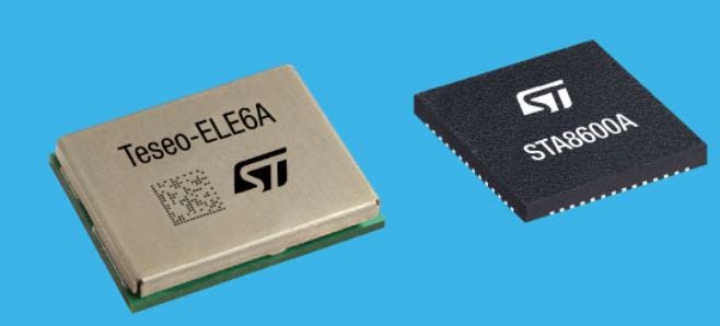
STMicroelectronics exhibited its Teseo VI GNSS receivers at this week’s Mobile World Congress. The ProPoint Go and Teseo VI solution will be on display at Embedded World Conference next week in Nuremberg, Germany.
Swift Navigation Integrates Skylark into Teseo VI, Point One Partners
Another company, Swift Navigation, said its Skylark Precise Positioning Service is integrated into Teseo VI. The company says that the integrated product would be an end-to-end solution for automotive autonomy.
Teseo VI is also optimized to run Swift’s Starling Positioning Engine, which fuses wheel odometry and IMU sensor data with Skylark’s GNSS corrections, the company said.
Finally, Teseo VI will also have Point One Navigation’s positioning engine, Fusion Engine, integrated for such industrial applications as drones, scooter, motorcycle, car, mower, or any kind of autonomous vehicle.
u-blox Introduces PointPerfect Live, Launches GNSS Receiver
Thalwill, Switzerland-based u-blox this week launched PointPerfect Live, a network RTK correction service with centimeter-level positioning. The company is tailoring the service for such markets as surveying, construction, mining, and agriculture.
PointPerfect Live, which the company says builds on its existing PointPerfect service leverages a large network of reference stations for corrections in local data formats, the company said. The network infrastructure spans Europe and North America.

The company said that PointPerfect Live will be available for initial test customers next month, with a larger market available in May.
In other company news, u-blox rolled out its newest GNSS module, the ZED-X20P. The module, with centimeter accuracy, is marketed to the industrial sector, including smart construction, surveying, precision agriculture, rail, maritime, mining, deformation monitoring, unmanned aerial vehicles (UAVs
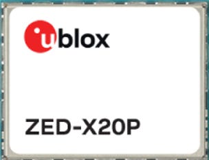
The ZED-X20P is compatible with such GNSS correction services as PointPerfect. The module also offers built-in support for Galileo E6, meaning customers will have access to the free-to-use Galileo High Accuracy Service (HAS), as well as any standard-compliant RTK service, including free and commercial options, the company said.
Editor’s Note: We covered u-blox’s 2024 year-end financials, and impacts from a challenging year, in our paid subscriber section in this issue.
Weekly Location Industry News
News tip? Send them to kdennehy@driverlessreport.com. Go to www.locationbusinessnews.com for more news. Location Business News is looking for your company’s news, products and use cases to feature in each issue.
Top News:
🌒 Firefly's Blue Ghost Lands on Moon and Will Attempt to Tap into Earth GPS. “Firefly's Blue Ghost lander touched down on the lunar surface and one of the experiments mounted onboard will try to do something almost unimaginable — tap into Earth's GPS constellations all the way from the moon. If successful, this will be the first time this has ever been done from the lunar surface.”
💲 VIAVI to Acquire Spirent’s Ethernet and Network Security Testing Business. While it didn’t get Spirent’s GPS and positioning products business, VIAVI VIAV 0.00%↑ purchased the company’s ethernet and network security testing business from Keysight Technologies KEYS 0.00%↑ for $410 million.
👍 Verizon Adds New Partners Singtel, Skylo to Worldwide IoT Platform. “Singtel joins Bell Canada and Telenor IoT as Mobile Network Operator (MNO) partners providing international IoT connectivity through Verizon’s VZ 0.00%↑ Global IoT Orchestration. Skylo is powering satellite-IoT connectivity and services for network assurance in areas where terrestrial connectivity is challenged. Verizon Business IoT customers can now access wireless services in up to 200 territories around the world, conveniently managed through Verizon Business’ ThingSpace IoT management platform.”
🎖 US Army Approves Production of Vehicle-Mounted GPS Alternative. “The U.S. Army approved the full-rate production of a Collins Aerospace-developed vehicle-mounted PNT system. The Mounted Assured, Positioning, Navigation and Timing System, or MAPS, is a key element of the service’s modernization push.”
🛰 Astranis Demonstrates GPS Capability in Race for Space Force Contract. “Astranis is working under an $8 million U.S. Space Force contract for the Resilient GPS (R-GPS) initiative. The company is competing with L3Harris and Sierra Space for the next phase of the program when the Space Force is expected to select a vendor to deploy eight R-GPS satellites by 2028. As many as 24 R-GPS spacecraft could be acquired subsequently.”
✈ IATA Reiports 500 Percent Spike in GPS Spoofing Last Year. “Interference rates shot up by 175 percent, while GPS spoofing incidents spiked by 500 percent year-over-year.”
👌 Planes Are Having Their GPS Hacked. Could New Clocks Keep Them Safe? “The plan is simple: to develop a more secure alternative to GPS by enabling the portable use of new atomic clocks, rather than relying on signals from satellites in space that can be jammed. But its execution is fiendishly difficult: to harness the power of the atom, develop a new type of clock, and even change the way we measure time itself – all within a few years.”
🌍 Patriot Announces Discovery of a Large Cesium Zone at Shaakichiuwaanaan. “Cesium is also used in atomic clocks, GPS, aircraft guidance, and telecommunications.”
✔ PNT: How The US Military Plans To Address GPS Jamming Vulnerabilities.

Expert nationwide installation services for fleet technologies.
Maps:
🤨 Google Maps Lists an Oakland Homeless Encampment as “Homeless Encampment,” Hilarity Ensues. “In our coverage of homeless encampments, there is rarely much humor or reason to laugh. Yet here we have a case that is somewhat amusing, though perhaps with mean-spirited intentions. KRON4 reports on a homeless encampment in East Oakland near the Fruitvale district, which is now listed as a business called “Homeless Encampment,” and quickly drew a number of mocking reviews.”
👏 TomTom Joins EU AI Champions Initiative to Accelerate AI Development in Europe. “Earlier this month TomTom, along with more than 60 other Europe-based companies, joined and launched the EU AI Champions Initiative. The initiative, unveiled by French President Emmanuel Macron at the AI Action Summit in Paris on Feb. 10, seeks to help AI tech reach its full potential in Europe”
🗺 TomTom Annual Report Now Available. TomTom’s Annual Report is now available, which includes its growth in the enterprise business unit.
👉 Google Maps Has New Car Icons, and Users Will Love Them. “Google GOOG 0.00%↑ has updated Google Maps with new vehicle icons, so instead of the blue arrow and the generic colorful icons, you can now choose from a wider array of vehicles. Google has also added more color settings available for every vehicle icon.”
📙 Esri Publishes New Book on the Rapidly Evolving Mobile GIS Field.
🥇 OpenStreetMap is participating in Google Summer of Code 2025. “OSM has been accepted as a mentoring organization for this year’s Google Summer of Code, a global program that offers students and new open source developers stipends to write code for open source software projects.”

Become a Paid Subscriber to Location Business News! Only $8 per month!
What Paid Subscribers get:
Full access to more than 200 Archived issues (stories, contacts, analysis).
A new subscriber-only Chat Board.
Access to Analysis and In-Depth Articles, plus People and Jobs.
Free entry to LBN-branded webinars and receptions at major trade shows (in development).
Steep Advertising Discounts for paid subscribers and Founding Members.
We average 30,000 views on our websites each month. Advertising starts at only $150 per issue. Please contact us at info@driverlessreport.com for more information…or go to our updated Advertising Page.
Connected and Autonomous Vehicles:
🚗 Hyundai and Avride Team to Develop Robotaxi Fleet. “The collaboration will focus on the development of autonomous vehicles equipped with Avride’s driving system, while also expanding Avride’s fleet of Hyundai IONIQ 5 vehicles, according to a Wednesday (March 5) announcement on Avride’s blog.”

🏎 New Autonomous World Speed Record Set With Indy Autonomous Challenge Maserati MC20. “AI-Driver of Politecnico di Milano sets new autonomous speed record with Indy Autonomous Challenge Maserati MC20 Coupe, reaching 197.7 mph, during the 1000 Miglia Experience Florida, at Kennedy Space Center.”

🙂 Aurora Expresses Optimism for National AV Framework. “President Donald Trump’s new administration, including Transportation Secretary Sean Duffy, could help deliver a national standard for autonomous vehicles, Aurora AUR 0.00%↑ co-founder and CEO Chris Urmson said on an earnings call Feb. 12.”
🌎 Viasat and Partners Deliver First-Of-Its-Kind Direct-to-Device Demonstration in South America. “Viasat and its ecosystem partners GuardianSat, Quectel, and Acceleronix, successfully complete trial in Brazil to showcase direct-to-device connectivity for the automotive industry.”
🚘 Google-Backed Oxa Drives Alternative Approach to Autonomous Vehicles. “UK-based Oxa focuses on services in airports, retirement communities and industrial settings, rather than personal cars and taxis.”
🤔 How Close Are We To Self-Driving Taxis in Europe? “Despite major advancements in autonomous driving, robotaxis aren’t a common sight in Europe. This is mostly due to regulations. With numerous countries enforcing different laws, meeting every specific requirement poses a significant challenge.”
Fleet Telematics:
🚍 Geotab and Daimler Truck North America Partner to Deliver Advanced OEM Integration for Freightliner Vehicles. “Geotab has announced an expansion of its OEM integration with Daimler Truck North America Freightliner trucks. This enhancement includes support for trucks equipped with Cummins Powertrains, enabling fleets to streamline operations through efficient access to critical vehicle data and actionable insights.”

🙂 Toyota Europe Partners with Targa Telematics. “The agreement enables integration of fleet data streams into Targa Telematics’ platform, leveraging vehicle information such as mileage, fuel consumption, EV metrics, and GPS positioning.”
🚚 Ford Pro Fleet Management Solutions Unveiled at Work Truck Week.
⚡ Orbcomm Joins the Geotab Marketplace Order Now Program. “Fleets will now have direct access to purchase ORBCOMM smart trailer visibility technology including the CT 1000, GT 1220 and GT 1230 through the Geotab Marketplace for trailer management.”
🚛 Samsara Helps FM Conway Reduce Accidents Across its Fleet by 20 Percent. “Samsara has announced infrastructure services company FM Conway has mitigated safety risks across the 16 million miles driven annually by its 1,000+ fleet of vehicles by implementing its AI and fleet management solutions.”

The D-Day Visitor's Handbook: Your Guide to the Normandy Battlefields and WWII Paris by Kevin Dennehy and Steve Powers. The guidebook uses location technology from what3words to locate monuments, museums and other attractions. Get your guidebook today.
Weekly Product News
Send your news releases to kdennehy@driverlessreport.com. Go to www.locationbusinessnews.com for more news and an archive of stories.
HERE Technologies Holds Top Ranking in Counterpoint’s 2024 Location Platform Effectiveness Index
HERE Technologies received the top spot in Counterpoint’s 2024 Location Platform Effectiveness Index, ranking first among 27 evaluated vendors, including Google GOOG 0.00%↑, TomTom and Mapbox. Counterpoint said HERE led in eight out of 10 categories, including customers, partnerships, AI capabilities and data platform.

The 2024 report also highlighted HERE’s open-platform strategy and privacy-first approach, the company said. The company’s collaboration with AWS was noted in the study. For more information on the Counterpoint 2024 Location Platform Effectiveness Index, visit: https://www.here.com/platform/counterpoint-report-2025.
Contact: Jordan Stark, HERE Technologies, (312) 316-4537, jordan.stark@here.com, www.here.com.
Hexagon | NovAtel Enhances Fusion Tech with GPR Partnership
Hexagon | NovAtel has announced it will enhance its SPAN GNSS+INS solution by adding ground-penetrating radar sensors from Massachusetts-based GPR. Under the agreement, GPR’s WaveSense ground-penetrating radar technology will be integrated into NovAtel’s SPAN solution to deliver subsurface mapping technology and centimeter-level accuracy, the company said.

Adding WaveSense means SPAN can provide an accurate position, velocity and attitude (PVA) solution without access to GNSS signals for extended periods caused by obstructions, scintillation events or jamming attacks, the company said. Through the MOU, both parties will collaborate on integration for selected use cases before moving on to a full product definition and supply agreement, the company said.
Contact: Vanya Banjac, GPR, (904) 463-3757, vanya@gpr.com, www.gpr.com.
ProStar and Point One Navigation for Worldwide Precision Mapping and Asset Management
ProStar has partnered with Point One Navigation to integrate Point One’s correction services into ProStar’s PointMan solution. The partnership aims to give PointMan customers centimeter-level accuracy for precision mapping, the company said. Point One’s Polaris RTK corrections network is powered by more than 2,000 base stations in the United States, United Kingdom, Europe, Australia, South Korea, and Japan.
Contact: Page Tucker, ProStar, ptucker@prostarcorp.com, www.prostar.com.
NextNav Demonstrates Positioning Reference Signal-Based PNT Technology
NextNav NN 0.00%↑ has announced the successful completion of lab and field demonstrations of its PNT solution based on Positioning Reference Signal (PRS) standards in 5G waveforms. The demonstrations culminated in a successful field test using a prototype network operating on NextNav’s existing spectrum in Palo Alto, Calif., the company said. The company said that the tests validated effectiveness of NextNav's 5G PRS-based PNT solution, demonstrating timing synchronization and positioning capabilities, establishing a foundation for widespread commercial deployment.
Contact: NextNav, www.nextnav.com.

Create a FREE ManyMe Account.
Teledyne Optech CZMIL SuperNova Used in Project
Teledyne Geospatial has announced that partner Tetra Tech won MAPPS awards for a single project using the Teledyne Optech CZMIL SuperNova. The awards include the MAPPS award for Airborne Acquisition and Processing, the MAPPS Member Choice Award, and the MAPPS Grand Award.
The project involved a hydrographic survey in the Republic of Kiribati in the Central Pacific. The technology used in this project included the CZMIL SuperNova, Starlink for remote network access, Garmin GRMN 0.00%↑ satellite messengers, and a solar panel array to support power needs.
Contact: Jennifer Parham, Teledyne Geospatial, jennifer.parham@teledyne.com.
CenTrak Expands RTLS Platform in Healthcare
CenTrak has announced the expansion of its RTLS portfolio with the launch of a Bluetooth Low Energy (BLE) platform for healthcare markets. The platform can transition between BLE-only, BLE multi-mode, and clinical-grade locating networks, the company said
Contact: CenTrak, centrak.com.
TCarta Announces Satellite Derived Bathymetry Product
TCarta has introduced a new line of Satellite Reconnaissance Charts to supplement official marine navigation maps in shallow waters. TCarta, which rolled out the products at the 2025 Esri Federal GIS Conference, says the charts are digital maps adhering to International Hydrographic Organization S-57 and S-100 data model standards.

The TCarta Satellite Reconnaissance Charts contain up-to-date details of seafloor depths, sandbars, reefs, shoals, and other submerged hazards – along with floating dangers – in the near-shore environments that are often poorly mapped or out of date on official maritime charts, the company said.
Contact: TCarta Marine, info@tcarta.com, www.tcarta.com

Click HERE to Join our growing Location Business News LinkedIn Group!
FCC to Explore GPS Alternatives
After years of national security concerns, the U.S. Federal Communications Commission said yesterday that it vote on March 27 to assess alternatives to GPS.
Keep reading with a 7-day free trial
Subscribe to Location Business News to keep reading this post and get 7 days of free access to the full post archives.