Intel To Sell Part of Mobileye for $1.5 Billion
Lidar manufacturer's stock has doubled since last year's IPO
Intel Corp. INTC 0.00%↑ plans to sell a part of Mobileye Global MBLY 0.00%↑, maker of lidar systems, for about $1.5 billion, according to a U.S. Security and Exchange commission filing. In the filing, Intel said it would be offering 35 million Class A common stock in Mobileye—to bring its ownership of the Israel-based company down from 99.3 percent to 98.7 percent.
Although down by 5 percent this week, shares of Mobileye have doubled since it went public last year in an $861 million offering. Mobileye’s customers include BMW, Nissan and Volkswagen.
According to published reports, Mobileye faces competition in the autonomous vehicle market from such semiconductor giants as Qualcomm QCOM 0.00%↑ and Nvidia NVDA 0.00%↑.
Lidar Market Could Become Much Larger…
The U.S. Transportation Department’s National Highway Traffic Safety Administration issued a Notice of Proposed Rulemaking requiring automatic emergency braking and pedestrian AEB systems on passenger cars and light trucks. The proposed regulation could spur a new run on lidar solutions.
If adopted, nearly all U.S. light vehicles (gross vehicle weight rating of 10,000 pounds or less) will be required to have AEB technology three years after the publication of a final rule. AEB systems use lidar, cameras and other optical sensors to detect impeding vehicles.
Expert nationwide installation services for fleet technologies.
OneNav Closes $17 Million Round, Launches GNSS Augmentation Product
Sunnyvale, Calif.-based oneNav has announced the closing of a $17 million Series C funding round and launched its pureL5 Acquisition Receiver Core (pARC). The funding round, led by MVP Ventures, includes participation from previous investors Google Ventures, GSR, Norwest Venture Partners and In-Q-Tel.
The company said the new funding round was at an increased valuation over earlier funding. Overall, oneNav has raised $50 million.
“There’s a huge demand for vastly better GNSS performance in phones, watches and IoT trackers. This new funding will be used to ramp up our support for many more tape outs in 2023 and 2024,” said Steve Poizner, oneNav CEO and co-founder.
The new pureL5 pARC product can augment customers’ existing GNSS solutions, which saves time and money, said Ellen Kirk, oneNav vice president, strategic marketing and business development.
“[pARC] is a standalone solution. Customers have many hours invested in their measurement and positioning engines—they aren’t going to take them out,” she said. “What they do not have is direct L5 acquisition. All hybrid solutions acquire L1 first, then acquire L5.”
Contact: Ellen Kirk, oneNav, (650) 678-0240, info@onenav.ai, www.onenav.ai.
Power Your Business with Vetted Digital Marketing Experts
GrowTal's marketing experts are pre-vetted and experienced, so you can focus on taking your business to the next level. Anywhere from social media management and SEO to paid social channels and high-level strategists. GrowTal experts are ready to work.
GAO Recommends GPS Modernization
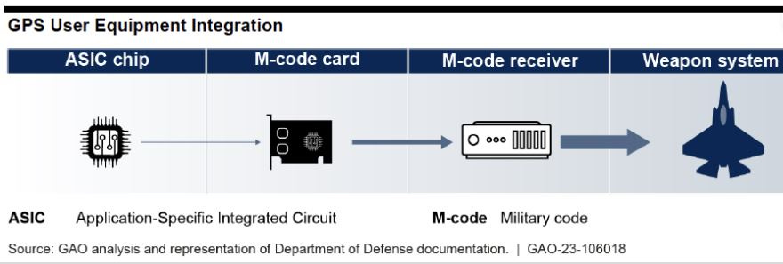
In a GPS modernization report released this week, the Government Accountability Office (GAO) said that the U.S. Space Force needs to develop a sound business case for new M-code capable handhelds. The agency also said that the service needs to assess the number of GPS satellites necessary to meet operational needs.
GAO, which said that the U.S. Defense Department agreed with both of its recommendations says the Space Force seeks to expand M-code technology use by developing a second increment that consists of an improved chip and card—and a handheld receiver. However, the organization contends that the Space Force lacks a committed customer for the handheld receiver.
“The [U.S.] Army, the largest potential user of such a device, has its own plans for handheld receivers, and Marine Corps officials say the service is still considering its options,” according to the report. “Without a sound business case for its proposed handheld product, Space Force risks expending significant resources without providing a benefit to military users.”
The report said that while Space Force “seems well situated to achieve its approved requirement of keeping 24 M-code capable satellites in operation,” the service’s own analysis indicates that 27 satellites are necessary to meet real-world needs.
While not on the list of formal recommendations, GAO took a shot at the delays to the GPS Next Generation Operational Control System (OCX) program. “While Space Force has not finalized a new schedule for the program, officials acknowledged that the expected delays reflect slower-than- expected progress, and there are still risks to the program. If testing reveals additional deficiencies or any other unexpected issues arise, the program may delay the delivery further because little margin remains in the proposed schedule,” the report said.
Your First Draft, Fast
Looking for some words of inspiration to kickstart your creative process? Magic Write in Canva Docs is your very own AI text generator to help you get out a first draft, fast. Simply start with a prompt and watch as copy, blog outlines, lists, bio captions, content ideas, brainstorms, and more appear in seconds.
Mapping Platform Atly Grabs $18 Million in Funding
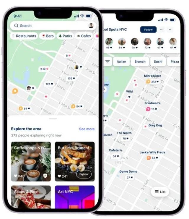
Social mapping platform Atly has officially launched with $18 million in funding from Target Global, Tal Ventures, and FKA Brands to offer users location-based content. Atly, in its open beta, said it has stewarded thousands of user-created community-based maps.
The company says hundreds of new maps are generated organically each month across such verticals as food and restaurants, travel, nature and the outdoors, parenting, and more. Atly says that digital search is undergoing a transformation as people are turning to resources beyond Google Search and Google Maps. The company contends that platforms like TikTok and Facebook were not purpose-build for location-based discovery.
"From Blogger to YouTube to Instagram and TikTok, people seek both community and information online, and they're often finding that intersection on social media. But there is a gaping hole when it comes to location-based information, which is where Atly comes in," said Uriel Maslansky, company CEO and co-founder, in a statement.
The company is bringing mapping up to speed by enabling people to search for the specific things they actually want—via its organically grown user-base, said Joshua Kaufman, Atly co-founder.
"It makes no sense. We search for things like 'cafe' or 'restaurant,' when in reality, these are simply proxies for the things we are actually searching for, whether that's a place that serves cold brew or some mouth-watering French toast,” he said. “And when we finally find a place, the rating and reviews are unreliable. Is the cafe rated 3.5/5 because of the coffee? The atmosphere?”
Contact: Allison Grey, for Atly, (323) 283-8176, atly@headline.media, www.atly.com.
Get smarter in 5 minutes with Morning Brew (it's free)
There's a reason over 4 million people start their day with Morning Brew - the daily email that delivers the latest news from Wall Street to Silicon Valley. Business news doesn't have to be boring...make your mornings more enjoyable, for free.
Apple Maps Goes Offline
Lost in the product rollouts at its WWDC event this week was Apple’s AAPL 0.00%↑ announcement that users will be able to use Apple Maps offline, with the iOS 17 update, later this year.
While Google Maps has had this feature for years, iPhone users will now have the option to continue navigation in areas with bad cellular coverage—as long as they download the maps in advance.
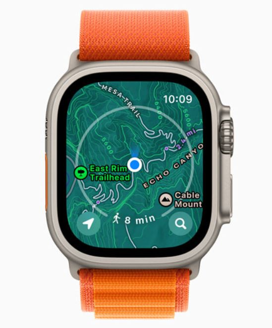
Apple didn’t say much about its new offline maps, but they will provide access to turn-by-turn navigation, estimated time of arrival and places in Maps. The features can be used on a paired Apple Watch that is in range of its companion iPhone, the company said.
The new watchOS 10 features a new Elevation view that uses altimeter data, offering a three-dimensional view of saved waypoints, the company said. In the United States, Apple Maps will display a new topographic map featuring contour lines, hill shading, elevation details, and points of interest. For hiking, the company said users can search for nearby trails and trailheads, with place cards that include detailed information, like trail length, type and difficulty.
Other Location News:
News tip? Send them to kdennehy@driverlessreport.com. Go to www.locationbusinessnews.com for more news and an archive of stories.
Top News:
🏛 New York Includes Geofencing Ban in Budget Bill. “The bill defines geofencing as establishing ‘a virtual boundary of (1,185 feet) radius or less…around a particular location that allows a digital advertiser to track the location of an individual user and electronically deliver targeted digital advertisements directly to such user's mobile device upon such user's entry into the geofenced area.’”
⚡ Decision on the Notice of Application Received from Ligado Networks (Canada). “Ligado sought approval for broadcast in Canada, on frequencies near those of GPS, and was denied.”
🌎 Galileo Second Generation Enters Full Development Phase. “Following the opening session of the European Navigation Conference, ESA director of navigation Javier Benedicto invited Thales Alenia Space, Airbus Defence and Space and Thales Six GTS to sign the respective contracts commencing System Engineering Support for the next generation of Europe’s navigation satellite system.”
🛰 SSC Completes Final Delivery of 2nd USSF Hosted Payload to Japan. “The two Space Force payloads, developed by MIT Lincoln Laboratories, will be hosted on Japan’s GEO-based, Quasi-Zenith Satellite System (QZSS).”
🤨 California Assembly Passes Bill to Restrict Geofence Location Tracking. “AB793 would prohibit geofencing. This technique allows police to search broad geographical areas and identify every electronic device in the area.”
🌍 EGNOS Latest Payload Becomes Operational Ahead of V3 Service. “Launched onboard EUTELSAT’s Hotbird 13G satellite in November of 2022 from Cape Canaveral, the EGNOS payload transmitted the first EGNOS V3 test signals on June 1, 2023, according to the European Union Agency for the Space Program (EUSPA).”
✈ L3Harris Won't Attend the Paris Air Show. “Nobody’s sold a darn thing [at] the Paris Air Show for 40 years—or at least I haven't. So we're not going there,” L3Harris LHX 0.00%↑ CEO Chris Kubasik said.”
😊 Tsunami Detection Along the Pacific Ring of Fire Gets a Boost From New Satellite Technology. “The new, experimental monitoring system, GUARDIAN (GNSS Upper Atmospheric Real-time Disaster Information and Alert Network), can use data from clusters of GPS and other satellites that orbit Earth.”
Maps:
👍 FCC Unveils Updated Broadband Map for Closing the Digital Divide. “The new map improves accuracy by utilizing a location-based approach and incorporating stakeholder challenges, providing a more comprehensive understanding of broadband availability.”
🗺 It Is Time to End Google's Monopoly in Maps, Apple Has Already Done That: Mapmyindia CEO. “Currently, users are not aware of the MapmyIndia Mappls app and what it offers. And that is because Google GOOG 0.00%↑ has had a monopoly over its Android operating system, where it pre-installs Google Maps, which makes it the default mapping service for users.”
😏 5 Must-Have Features for Any Google Maps Killer. “I don't know about you, but support for offline maps is mandatory for an application that provides route guidance in my car.”
🙂 Polestar's Latest Software Update Adds YouTube, Upgraded Apple Carplay. “Polestar’s latest software update includes YouTube so Polestar 2 owners can watch streaming video while charging their vehicles and an updated version of Apple CarPlay that includes the ability to project Apple Maps onto the instrument cluster.”
Reach nearly 15,000 subscribers and 70,000 more via social media by advertising in Location Business News!
We can promote your webinar, service or product to a focused group of industry executives. Email us at info@driverlessreport.com for more information, or click here to view our one-page media kit.
Connected and Autonomous Vehicles:
🏡 Ex-CEO of Google’s Waymo Buys Modernist Bonanza in Santa Monica Canyon. John Krafcik, former CEO of Waymo, buys a $9.6 million mansion.
🚗 The "Death of Self-Driving Cars" Has Been Greatly Exaggerated. “GM’s GM 0.00%↑ Cruise aims to turn self-driving into a billion-dollar business.”
🚚 California Lawmakers and AV Industry Battle for Future of Self-Driving Trucks. “A California bill that would require a trained human safety operator to be present any time a heavy-duty autonomous vehicle operates on public roads in the state is getting traction.”
🚛 Luminar and Plus Partner up To Bring Lidar- And AI-Led Driver Assist to Commercial Trucking. “Automated and fully autonomous driving developer Plus has selected Luminar LAZR 0.00%↑ as its exclusive long-range lidar provider to support its PlusDrive assisted driving system for commercial vehicles.”
🤞 Aeroporti di Roma Ventures Invests in Ottonomy. “ADR Ventures, the new corporate venture capital arm of Aeroporti di Roma, announces its initial venture investment with Ottonomy.”
✈ Air Force Fast-Tracks Autonomy With Xwing. “Xwing and the Air Force will complete flight tests and other trials over the next 21 months in northern California using Xwing’s Cessna 208B, the same platform in which the company demonstrated an autonomous gate-to-gate flight in 2021.”
Drones:
😒 Gangs Using Drones as Spring Sees Surge in Tractor GPS Theft. “Gangs of organized criminals are travelling across the country to scope out farms using vehicles and drones before stealing high-value GPS from tractors and sprayers.”
🔥 Fire-Bombing Drones Keep Firefighters Safe in Prescribed Burns. “The National Science Foundation’s National Research Traineeship program at the University of Nebraska-Lincoln uses a drone to drop fireballs to ignite prescribed burns, keeping firefighters out of harm’s way.”
🛩 Drones Assist Iowa DOT in Directing Traffic Around Wrecks. “The Iowa Department of Transportation is testing how well unmanned aerial systems can help to move traffic around wrecks, temporary road closures and construction zones.”
Military:
🛳 Navy Lets Honeywell Contract to Supply Ring Laser Gyros for Navigation and Guidance Aboard Surface Warships. “Officials of the Naval Supply Systems Command Weapon Systems Support activity announced a $12 million contract awarded to Honeywell HON 0.00%↑ to provide ring laser gyros for the AN/WSN-7 inertial navigation system.”
🚀 Lockheed Martin To Test and Integrate Air-To-Ground Missile With GPS. “Lockheed Martin LMT 0.00%↑ will help the U.S. Air Force develop a precision-guided air-to-ground missile under a potential $240 million contract.
Financial:
Engaging Short-Form Video for B2B SaaS
Spacebar Visuals creates engaging short-form videos for B2B SaaS companies by turning your written content, such as blog posts, eBooks, surveys and more into engaging video content to drive top- and mid-funnel lead gen.
Location Industry Briefs
Send your news releases to kdennehy@driverlessreport.com. Go to www.locationbusinessnews.com for more news and an archive of stories.
Geotab Showcases Canadian Innovations
Geotab is a technology partner in Project Arrow, an initiative by The Automotive Parts Manufacturers' Association (APMA) of Canada to develop the first all-Canadian, zero-emission concept vehicle. Geotab is contributing to the development of the Mutualism partnership's intelligent cockpit, which aims to transform the driver experience in next-generation vehicles, the company said.

Earlier this year Geotab, with Synop, announced a partnership that will give fleet operators in North America access to integrated EV charging and energy management within Geotab's software platform, MyGeotab. The company, working with General Motors (GM) in Canada, Geotab announced the expansion of its integrated telematics solution. Geotab's offering allows Canadian customers to manage their fleet with OnStar embedded factory hardware.
Contact: Geotab, www.geotab.com.
Parkopedia Partners With Valtech Mobility
Parkopedia and Valtech Mobility have partnered to provide vehicle-centric digital services to drivers. The deal combines Parkopedia’s parking, charging and payment processing expertise with Valtech Mobility’s app creation, integration and backend development experience, the company said.

Some of the markets that Parkopedia and Valtech Mobility, a joint venture of the Volkswagen group and the digital agency Valtech, are going after include parking, charging, fueling and road tolls. The companies plan to offer the service to automakers that will cover the in-car transaction process, from individual point of interest data, to user registration and payment processing, enabling automakers to offer a frictionless in-car commerce experience, the companies say.
Contact: Adam Calland, Parkopedia, 44(0)7838219129, adam.calland@parkopedia.com.
Oxbotica Partners With Google Cloud
Oxbotica has announced a strategic collaboration with Google Cloud that it hopes will accelerate the deployment of its autonomous software platform. The partnership will combine Google Cloud's expertise in cloud infrastructure with Oxbotica's autonomous vehicle software to create business autonomous driving solutions. Oxbotica plans to use Google Cloud products to help develop, test, validate, and verify its self-driving technology, the company said.
Contact: Oxbotica, www.oxbotica.com.
U.S. Carrier Selects NextNav’s Pinnacle
NextNav NN 0.00%↑ has been selected by “a nationwide U.S. carrier” to deliver vertical location capabilities for Enhanced 911 via its Pinnacle service. The agreement allows z-axis data for 911 calls made on the carrier’s entire device portfolio, the company said.
NextNav says that multiple wireless operators, which they haven’t named, have selected its Pinnacle service to provide z-axis capabilities for caller geolocation and emergency response. This includes “a tier-one carrier” that launched the service on several device in past few months, the company said.
Contact: NextNav, media@nextnav.com, https://nextnav.com.
Sheeva.AI and APSG Partner
Sheeva.AI and Athena Partners Strategy Group have announced a strategic partnership that will see them collaborating on bringing parking transactions to worldwide connected car infotainment screens. Sheeva.AI, which provides vehicle location-based services via its SheevaLocate, allows drivers to pay for and receive EV charging, fueling, parking, curbside pickup, drive-thru and tolling services. The partnership will bring parking payment apps and pay station and meter companies into the car, the company said.
Contact: Trevor Curwin, Sheeva.AI, (415) 646-6063, tcurwin@sheeva.ai, www.sheeva.ai.
U-blox and Tallysman Wireless Partner
U-blox and Tallysman Wireless have signed a design partner agreement for the development of next generation PointPerfect RTK-augmented smart antennas. The PointPerfect GNSS augmentation service is now available in North America, Europe, and parts of Asia Pacific.
The deal calls for the u-blox ZED-F9R GNSS and the NEO-D9S L-band receivers integrated with Tallysman’s Accutenna technology.
Contact: u-blox, www.u-blox.com.
Mercedes-Benz Displays In-Car Payments
Mercedes-Benz Financial Services USA said its new in-car payment feature is available on any Mercedes-Benz in the United States equipped with the MBUX infotainment system and on-board navigation. The system features in-car payments for off-street parking from partner Parkopedia.
The system allows drivers to identify available off-street parking facilities and reserve a parking space via the infotainment system, the company said. The system also enables motorists to select check-in and check-out times, and view the total cost and confirm their booking, at which point drivers will be sent a QR code to scan when arriving at the car park to gain entry, the company said.
Contact: Lynn Munroe, for Mercedes-Benz, (845) 548-1211, egcpr@egcgroup.com, www.mercedes-benz-mobility.com.
Create a FREE ManyMe Account.
WirelessCar Opens Germany Office
WirelessCar has opened a German branch in Munich. Theo-Han Jansen, who has more than 30 years of experience in the automotive industry, will manage the soon-to-be hired team. WirelessCar develops software solutions for connected cars, including optimized EV routing and journey intelligence.
Contact: Noemi Kubiak, WirelessCar, 46 765 200727, noemi.kubiak@wirelesscar.com, www.wirelesscar.com.
Quectel launches FCM360W Wi-Fi 6 and Bluetooth 5.1 Module
Quectel Wireless Solutions has launched its latest FCM360W Wi-Fi and Bluetooth module that combines a high-performance processor with Wi-Fi 6 and Bluetooth 5.1 capabilities, the company said. The module is targeted to smart homes and industrial IoT use cases.
Contact: Quectel, www.quectel.com.
Airgain Announces Asset Tracking Alliance With Sensing & Control
Airgain AIRG 0.00%↑ has partnered with Sensing & Control (S&C), an IoT service provider based in Barcelona. Airgain’s trackers for the logistics, distribution, construction, manufacturing, and industrial industries will combine with S&C’s IoT experience for the Spanish market, the company said.
Contact: Marco Ceglie, Airgain, (602) 245 6212, mcegliex@airgain.com, www.airgain.com.
Queclink Introduces LTE Cat 4 Vehicle Trackers for Latin America
Queclink has just released two LTE Cat 4 vehicle trackers, GV58LAU and GV310LAU, in Latin America. The new GV58LAU and GV310LAU are 4G-enabled updates to Queclink's previous 2G/3G telematics products.
Both new products have BLE 5.2 that allows for Bluetooth connectivity. Other features include a temperature/humidity sensor, iButton, and CAN100 that can be connected to the devices via Bluetooth.
Contact: Queclink Wireless Solutions, www.queclink.com.
Ituran Brazil Partners With Santander
Ituran Location and Control ITRN 0.00%↑ has announced that its Brazilian subsidiary, Ituran Brazil, and Santander, have formed a partnership in the automotive market. The deal combines telematics services for customers who opt to install a vehicle tracker. In addition, the partnership incorporates credit insurance, to protect the financing which guarantees total or partial payment of the loan in case of inability to pay, the company said.
Contact: Udi Mizrahi, Ituran, 972 3 557 1348, udi_m@ituran.com, www.ituran.com.
Zonar Announces SoC Data For EV School Buses
Zonar has announced state-of-charge (SoC) data for electric vehicle (EV) school buses. SoC is captured with the Zonar V4 telematics control unit, providing school transportation departments with real-time awareness of each EV’s range and charging status, the company said.
Other features include vehicle location in real time, current and historic state-of-charge data, Stop-by-stop driving and charge analysis and trip duration and history.
Contact: Zonar, www.zonarsystems.com.
AiRISTA Announces Support for Cisco Catalyst Access Points
Real Time Location Services provider AiRISTA has announced support for application hosting on Cisco CSCO 0.00%↑ Catalyst series access points. Customers are able to deploy AiRISTA components like its Bluetooth Low Energy Angle of Arrival gateway to the Catalyst access point. The addition of AoA gateways to Cisco wireless environments provides such RTLS capabilities as submeter location accuracy and tracking, the company said.
Contact: AiRISTA, salesinfo@airista.com, www.airista.com.
People
Comtech CMTL 0.00%↑ has appointed of former Under Secretary of Defense for Acquisition and Sustainment Ellen Lord and former U.S. Army Chief Information Officer (CIO) Lt. Gen. Bruce Crawford to its board of directors.
Chris Oldham has been named IoT senior sales director/EMEA team manager at KORE KORE 0.00%↑
Phunware PHUN 0.00%↑ has appointed Troy Reisner as CFO. Reisner will succeed Matt Aune and will become a member of the company’s executive management team.
AiRISTA has appointed Wyatt Meek as global vice president of sales.
If you're a student in the US looking for a better way to pay for higher education, Bold provides thousands of students with $25k scholarships every year. Enter to win one of our monthly $25,000 scholarship to go towards your tuition, student loan debt, or other education related expenses!
Apply to a Bold scholarship today
Jobs
Jobs. TomTom.
Jobs. Pozyx.
Automotive Product Marketing Manager. Quectel.
Business Development Representative. PTV Group.
Business Development Manager - Orolia Defense & Security. Safran Navigation & Timing.
Careers. BindiMaps
Careers. Inrix.
Careers. oneNav.
Click HERE to Join our growing Location Business News LinkedIn Group!


