Japan Plans to Increase QZSS Satellites From Four to 11
The satellite constellation will not have to rely on GPS to operate
Japan this week announced plans to increase the number of its navigation satellites from four to 11. The announcement, made by the country’s space policy committee, allows Japan to operate its Michibiki Quasi-Zenith Satellite System (QZSS) without relying on the U.S.-based GPS, according to Nikkei Asia.
While no launch timetable was publicly revealed for the additional satellites, in a December 2022 space policy document, Japan called for a seven-satellite constellation to be launched in fiscal years 2023 to 2024, depending on the status of the H3 launch vehicle.
Currently, the QZSS satellites are in geosynchronous orbit above Japan and Australia. In the previously announced seven-satellite configuration, the constellation will consist of one quasi-zenith satellite, a geostationary satellite and one quasi-geostationary satellite to increase the range where QZSS signals can be received.
The first QZSS satellite was launched in 2010 on a Japanese H-IIA rocket. The system has four operational satellites since 2018. The rise of precise location information for autonomous vehicles, drone delivery services, and potential disruption of the GPS signal, has spurred countries to develop their own satellite navigation systems and or augmentation services.
In January, the U.S. Space Force delivered two hosted payloads for QZSS. Japan will integrate the payloads into two satellites it plans to launch. The payloads are designed to monitor spacecraft and dangerous debris in geosynchronous orbit.
The primary payload developer, Massachusetts Institute of Technology’s Lincoln Laboratories (MIT/LL), will travel to Japan to help with the payload’s integration and testing. Overall, the Space Force’s Space Systems Command is managing the program.
NUVIEW Plans to Map Earth Entirely With Lidar
NUVIEW has announced that it is building the first commercial lidar satellite constellation to map the Earth’s land surface in 3D. The announcement, made at the Geospatial World Forum in Rotterdam, calls for a new constellation of 20 lidar satellites to map all of the planet.
NUVIEW, which claims $1.2 billion in early adopter agreements, says that current satellite imagery gives users only a 2D view of the Earth, while only 5 percent has been mapping with lidar. This limited depth and accuracy precludes its utility for solving challenges in climate change, disaster response, sustainable farming, conservation and forestry, the company says.
“Our [lidar] satellite constellation will offer a wealth of information that has never before been available at scale, driving innovation and progress throughout numerous industries and revolutionizing the way we understand and interact with our planet," said Clint Graumann, NUVIEW CEO and co-founder, in a statement.
The new constellation will collect data more than 100 times faster than current commercial aerial solutions in an "always on" approach, the company said. It believes farmers will be able to optimize crop yields and water usage. It also said that city planners will be able to create more sustainable and efficient urban areas.
Optimize your Sales Strategy with Apollo
Search, engage and convert over 250 million contacts at over 60 million companies with Apollo’s sales intelligence and engagement platform.
[Sponsored]
Digital Matter Introduces Longest Life Battery-Powered IoT Asset Tracker
Digital Matter has announced that the next-generation Remora3 battery-powered GPS and Bluetooth Gateway is now available with global Cellular LTE-M (Cat-M1) and NB-IoT connectivity.
The Remora3 features ‘Deploy Once’ battery life and new ‘Second-by-Second’ tracking performance to support aggressive and/or extended reporting requirements, including highly accurate speeding, run hour, odometer monitoring on mobile assets such as rental equipment, trailers, vehicles and more.
“Substantial design and technology improvements on the Remora3 enable critical new use cases for our partners who require real-time tracking performance without the hassle of physically wiring in a device,” says Ken Everret, Digital Matter CEO and founder.
With a flexible and open payload format, extensive documentation, and regional technical support, the Remora3 can be integrated into any end-platform. Third-party Bluetooth sensors and tags are also supported.
Other Remora3 features include:
GPS location
Trip history
Asset recovery
Movement detection
Tip detection
Rotation counting
Impact detection
The Remora3 also functions as a Bluetooth Low Energy Gateway and can optionally scan for nearby Bluetooth tags and sensors for additional asset location and sensor monitoring applications. The Remora3 supports roaming across Cellular LTE-M and NB-IoT networks to enable global asset tracking and monitoring applications in supply chain visibility, logistics, returnables and more.
For more information on the Remora3 or Digital Matter’s other IoT asset tracking solutions, click here.
Contact: Shay Kettner, Digital Matter, shay@digitalmatter.com, digitalmatter.com.
Porsche and Mobileye Collaborate on ADAS
Porsche and Mobileye MBLY 0.00%↑have partnered to provide advanced driver assistance systems (ADAS) solutions, including automated assistance and navigation capability in future sports cars. In these new Porsche models, Mobileye will provide its SuperVision technology platform.
Despite Porsche’s parent company Volkswagen, along with partner Ford F 0.00%↑ , pulling the plug on autonomous vehicle startup Argo AI, the deal with Mobileye seems signals that the premium vehicle company is staying in autonomy markets.
Porsche says it will “take a leading role in the full integration” of SuperVision into its luxury cars. It says Mobileye’s systems will be not only be integrated by Porsche engineers, but will be customized by in-house specialists.
For its part, Mobileye says its SuperVision system enables drivers to take their hands of the steering wheel, depending on local laws, to monitor their surroundings. Drivers can use the system to follow navigation routes, autonomously change lanes and overtake slower vehicles on multi-lane roads, the company said.
Expert nationwide installation services for fleet technologies.
Pointr Launches Large Indoor Location System in Abu Dhabi Mall
Pointr is launching one of the world's largest single-site indoor location systems at the Reem Mall in Abu Dhabi, United Arab Emirates. The indoor location system covers all public areas of the mall—some 2.3 million square feet.
The company, which partnered Dimension Data on the project, said that Reem Mall will integrate indoor location features, called Deep Location, in its guest app. Shoppers will be able to use the app to find their position indoors, browse interactive maps and wayfind to the more than 400 stores in the mall, the company said.
Pointr said that the mall’s 6,000 parking spots were individually mapped to allow the app to direct shoppers to free spots. The company’s Deep Location capability, which works indoors and outside, allows app users to navigate anywhere in the mall’s 10 floors. The app also directs shoppers back to their vehicle with the quickest route, the company said.
Pointr said that the mall’s 6,000 parking spots were individually mapped to allow the app to direct shoppers to free spots. In addition, the company’s Deep Location capability allows app users to navigate anywhere in the mall’s 10 floors. The app also directs shoppers back to their vehicle with the quickest route, the company said.
In addition to Reem Mall, Pointr has indoor location services in Harrods and two the largest retail chains in the United States, the company said.
Contact: Marianne Slamich, Pointr, 447426321320, marianne.slamich@pointr.tech.
Get smarter in 5 minutes with Morning Brew (it's free)
There's a reason over 4 million people start their day with Morning Brew - the daily email that delivers the latest news from Wall Street to Silicon Valley. Business news doesn't have to be boring...make your mornings more enjoyable, for free.
Other Location News:
News tip? Send them to kdennehy@driverlessreport.com. Go to www.locationbusinessnews.com for more news and an archive of stories.
Top News:
🛰 Lockheed Martin Announces Reorganization of Its Space Business. “Lockheed Martin LMT 0.00%↑ announced it is consolidating several businesses focused on space into three sectors: Commercial civil space, national security space, and strategic and missile defense.”
💰 Private Equity Firm Closes $6.4 Billion Deal To Acquire Maxar Technologies. “The company was acquired by the U.S. private equity firm Advent International and minority investor British Columbia Investment Management Corp.”
😲 MWC's Organizer Slapped With GDPR Fine Over Biometrics ID Checks Due Diligence.
🤞 Google's Rumored Bluetooth Tracker Could Trump Apple's AirTags – Here's Why. “It's looking increasingly likely that Google GOOG 0.00%↑ will launch its answer to Apple AirTags and the Find My Network at Google IO 2023 – and new rumors suggest Google's system will support not just its own Bluetooth tracker, but third-party ones, too.”
Maps:
👍 OK Map Making Nerds — Where’s Your Revolution? James Killick: “As far as I can tell a ground breaking revolution in map making along the lines of what we’re seeing in generative AIs and auto manufacturing has yet to materialize.”
👌 New Report Claims iOS 17 To Display Turn-By-Turn Navigation Directly on the Lock Screen. “Apple AAPL 0.00%↑ is working on a new Live Activities feature for [its] Maps app that will display turn-by-turn navigation directly on the lock screen, according to Apple leaker @analyst941.”
📱 New Waze Version Released With Good News for iPhone Users. “While Apple has also integrated similar capabilities in Apple Maps, the feature is yet to gain traction. Furthermore, it only supports three different reports, whereas Waze includes many other categories, including vehicles stopped on the road, broken traffic lights, and roadkill.”
😀 Apple Will Start Mapping in Six Canadian Cities. “As announced by Apple AAPL 0.00%↑ on Twitter, teams will begin driving across Canada and walking in Toronto, Montreal, Gatineau, Ottawa, Calgary, and Edmonton beginning this month. As for exactly how the teams will be mapping out locations, Apple says Canadians can expect to see “specialized vehicles and backpacks” that the team will utilize in their outings.”
🤔 TomTom's Top GPS Navigator Makes Google Maps and Waze Feel Redundant. “The specs look good on paper, and there's nothing you'd miss when replacing a mobile phone with this GPS navigator.”
😕 I Tested the Top Google Maps Alternatives, So You Don’t Have To.
Reach nearly 15,000 subscribers and 60,000 more via social media by advertising in Location Business News!
We can promote your webinar, service or product to a focused group of industry executives. Email us at info@driverlessreport.com for more information, or click here to view our one-page media kit.
Connected and Autonomous Vehicles:
💰 Qualcomm to Acquire Autotalks. “The company provides automotive qualified dual-mode global V2X solutions compatible with multiple V2X standards that are designed to reduce collisions and improve mobility.”
🚘 Why Halo Is Betting on a Remote-Operated Car-Sharing Service. “The rub is that customers will not have access to self-driving features. Instead, the technology is only being used as a valet service for people looking for a short-term rental.”
🚗 Waymo Doubles Range of Its Self-Driving Taxi Service in Phoenix. “Waymo’s driverless taxis are coming to more parts of Phoenix, Arizona and San Francisco, the company announced in a blog post.
🙁 Ferrari Doesn't Care About Autonomous Vehicles, CEO Says.
Drones:
🛩 Japan's Biggest Drone Maker Sets Its Sights on the US. “The U.S. is a no-brainer for a company like ACSL. It’s a massive drone market, but government use has been stymied, in part by blacklisting. In October of last year, for instance, the Department of Defense included DJI on a list of Chinese military companies.”
😮 Skydio Drones Can Now Scan Indoor Spaces Autonomously. “US drone maker Skydio has updated its 3D Scan software to enable autonomous indoor mapping missions at large-scale facilities such as construction sites, factories, and warehouses.”
Financial:
✔ Garmin Announces First Quarter 2023 Results. “Consolidated revenue of $1.15 billion, a 2 percent decrease compared to the prior year quarter.”
✔ Automotive a Bright Spot for Qualcomm in Q2. “Handset demand down ‘at a magnitude greater than we previously forecasted,’ Qualcomm QCOM 0.00%↑ CEO said.”
✔ PowerFleet Reports Break-Even Earnings for Q1.
New Tech:
🙂 Quantum Lidar Prototype Acquires Real-Time 3D Images While Fully Submerged Underwater. “For the first time, researchers have demonstrated a prototype lidar system that uses quantum detection technology to acquire 3D images while submerged underwater.”
Compliantly hire anyone, anywhere, in 5 minutes with Deel
Deel is your one-stop shop for hiring, paying, and managing your remote team. We stay on top of local labor laws across the world to ensure compliance and mitigate risk so that you don't have to.
Location Industry Briefs
Send your news releases to kdennehy@driverlessreport.com. Go to www.locationbusinessnews.com for more news and an archive of stories.
Geotab Selected as Telematics Provider for the State of Minnesota
Geotab has been awarded a contract to sell telematics solutions to the state of Minnesota. Under the contract, state and local government agencies across Minnesota can purchase Geotab's telematics technology, the company said. Financial details were not disclosed.
Geotab's government fleet management customers include those who have public works, winter operations and electrification capabilities. The telematics solution offers mixed fleet data management, salt and plow tracking, and access to the Electric Vehicle Suitability Assessment (EVSA), the company said.
Contact: Geotab, www.geotab.com.
Trimble Rolls Out Drone Delivery Solution at Xponential Conference
Trimble TRMB 0.00%↑ rolled out its PX-1 RTX solution for positioning and heading of commercial drone delivery applications. PX-1 RTX allows drone integration companies to add positioning capabilities to allow operators to efficiently plan and execute takeoff, navigation and landing, the company said.
PX-1 RTX, launched at the AUVSI Xponential Conference in Denver, leverages Trimble’s CenterPoint RTX corrections and GNSS-inertial hardware to provide real-time, centimeter-level positioning, the company said.
Contact: Trimble, http://advancedairmobility.trimble.com.
FCC Waiver Enables HARMAN to Deploy C-V2X Tech
HARMAN International says it was “one of the select few companies recently approved by the FCC to operate roadside and on-board cellular-vehicle-to-everything (C-V2X) technologies within the 5.9 GHz band in the United States.” The company says road users, city planners and highway administrators can benefit from its C-V2X solutions. These include the HARMAN Savari StreetWAVE roadside unit and Savari MobiWAVE wireless vehicular on-board unit.
Contact: Dawn Geary, HARMAN, (248) 463-0921, dawn.geary@harman.com. www.harman.com.
HERE powers HERNAV Navigaton and Routing Solution
HERE Technologies has announced that it powers HERNAV navigation and vehicle routing solution from Hermes Germany. Introduced in late 2022, HERNAV features automotive-grade maps, real-time traffic, geocoding and navigation software through the HERE Software Development Kit (SDK).
HERNAV is used by more than 10,500 delivery drivers working for Hermes Germany. With HERE’s maps and services, HERNAV offers drivers a navigation solution with vehicle-specific routing, the company said.
In other HERE news, the company partnered with Neusoft to offer a “more competitive navigation product” by leveraging Neusoft's product solutions and HERE’s maps.
Contact: Sebastian Kurme, HERE Technologies, 49 173 515 3549, sebastian.kurme@here.com.
Advantix and Azuga Partner
Advantix and Azuga have formed a strategic partnership to roll out SmartSIM-enabled GPS fleet tracking and dashcam solutions that connect to such carriers as AT&T T 0.00%↑ Verizon VZ 0.00%↑ and T-Mobile TMUS 0.00%↑ in the U.S., and 475 providers worldwide.
By shipping the gear with Advantix SmartSIMs, Azuga eliminates the time-consuming need for fleet operators – or their IT equipment providers – to manually configure Advantix Access Point Names (APNs) in each device, the company said.
Contact: Azuga, www.azuga.com.
Septentrio Signs Distribution Partnership With Braemac
Septentrio has signed a distribution partnership with Braemac for North America and Mexico. Braemac will distribute the full Septentrio portfolio, including the compact mosaic module family, the company said.
Both companies, which will exhibit at Xponential in Denver this week, say that Braemac will offer GNSS antennas, wireless connectivity solutions and other products that are complimentary to the Septentrio product line. Septentrio said the deal will expand its market share in North America.
Contact: Septentrio, www.septentrio.com.
BlackBerry Radar Partners With McLeod
BlackBerry BB 0.00%↑ has announced a partnership with McLeod Software to integrate its Radar asset tracking into McLeod's Loadmaster trucking dispatch management system. The deal, of which financial details were not disclosed, allow McLeod customers to obtain real-time information on the status of their assets. Radar is targeted to trailers, chassis and containers to provide information about location, cargo status, trip events, mileage and door open/close status.
Contact: BlackBerry, (519) 597-7273, mediarelations@BlackBerry.com, www.blackberry.com/us/en/products/asset-tracking/partners/mcleod.
CANCOM Partners With Quuppa
IT service provider CANCOM has partnered with Quuppa to offer its customers a RTLS (Real-Time Location System) that features asset location. By adding location capability via Quuppa’s Intelligent Locating System, CANCOM said its customers can quickly gain visibility into their operational processes.
The CANCOM and Quuppa offering will be marketed to logistics, manufacturing, retail, healthcare and other industries. Some use cases include real-time monitoring of the supply chain, efficient management of inventory and load carriers, tracking of goods, people, tools and transport routes indoors, or in-store analytics, the company said.
Contact: Sari Arjamo-Tuominen, Quuppa, sari.arjamo-tuominen@quuppa.com, www.quuppa.com.
Nokia Unveils 5G Drone-In-A-Box Solution
Nokia NOK 0.00%↑ has launched the first CE-certified, turnkey drone-in-a-box solution for public safety agencies, smart cities, construction, energy and defense. CE-certified for European Union requirements, the Nokia Drone Networks solution connects over public and private 4G/LTE and 5G networks to enhance situational awareness for first responders and other professionals, the company said.
The solution includes Nokia drones, docking station, dual gimbal camera and edge cloud processing using Nokia MX Industrial Edge (MXIE). Beyond visual line of sight (BVLOS) operations with real-time kinetic (RTK) positioning improves situational awareness, the company said.
Contact: Nokia, press.services@nokia.com.
Create a FREE ManyMe Account.
VicOne Partners With TomTom
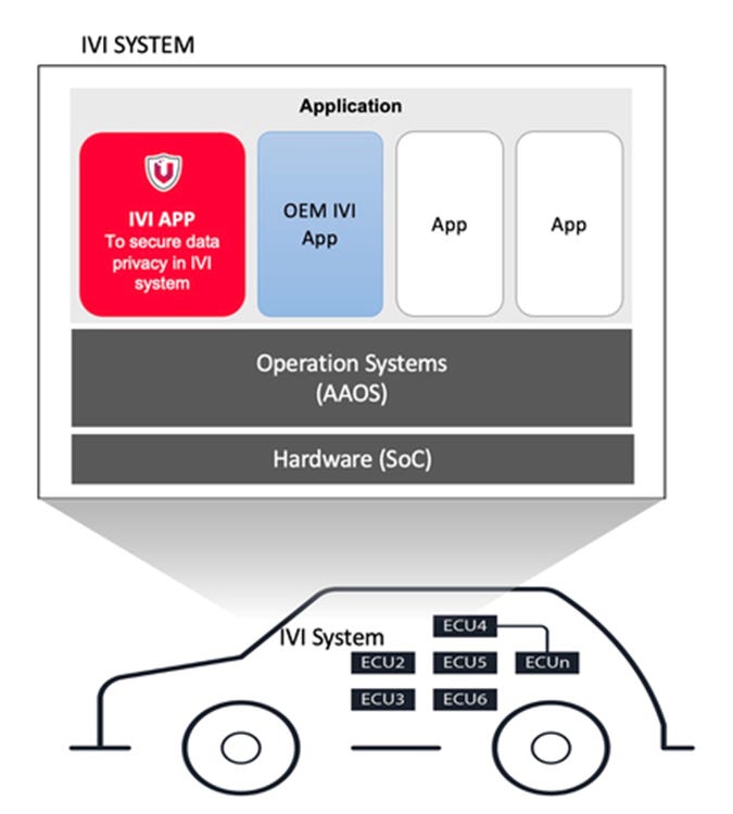
VicOne has partnered with TomTom [Tom2] to combine its xCarbon ECU intrusion detection and prevention systems with the TomTom Digital Cockpit. Working with TomTom, VicOne enables OEMs to protect their users’ data privacy in-vehicle through its smart cockpit cybersecurity software, the company said.
VicOne enables OEMs to provide multi-layered cybersecurity for their offerings and help car owners feel safe from cyberattacks before and after purchasing their cars, the company said.
Contact: Vivian Kelly, for VicOne, (703) 509.5412,viviankelly@interprosepr.com, www.vicone.com.
Spire Grabs CSA Contract for Wildfire Monitoring
The Canadian Space Agency (CSA) has awarded a contract to Spire Global SPIR 0.00%↑ to deliver preparatory work for implementation phases of a wildfire monitoring satellite. The contract is part of CSA’s planned WildFireSat mission to monitor active wildfires in Canada. Spire will partner with OroraTech for the contract.
Contact: Kristina Spychalski, Spire, Kristina.Spychalski@spire.com, www.spire.com.
Sheeva.AI Wins Location Analytics Solution of the Year
Sheeva.AI was awarded the 2023 Location Analytics Solution of the Year award in this year’s RetailTech Breakthrough Awards. The competition included 1,200 companies being nominated across all categories. Sheeva.AI’s technology can identify the location of a vehicle at a designated gas pump, parking space, EV charging station, or drive-through lane and activate the service point from inside the car, the company said. Israel-based Oriient also won the Indoor Mapping Solution of the Year in the same competition.
Contact: Trevor Curwin, Sheeva.AI, (415) 646-6063, tcurwin@sheeva.ai, www.sheeva.ai.
Ermewa Selects Nexxiot for Asset Management
Ermewa has selected Nexxiot to integrate asset monitoring technology for its fleet of more than 45,000 railcars. Nexxiot's asset monitoring technology allows for railcar availability, service flexibility, cargo quality, and safety, through real-time data and predictive analytics, the company said.
Ermewa will integrate Nexxiot's Asset Intelligence technology to its existing telematics portfolio, the company said.
Contact: Nexxiot, www.nexxiot.com.
Vantis Launches Surveillance Service Via Airspace Link Integration
The Northern Plains UAS Test Site (NPUASTS), Thales USA, and Airspace Link have announced the availability of localized surveillance data to registered UAS operators on Vantis, North Dakota's statewide uncrewed aircraft system (UAS) beyond visual line of site (BVLOS) network. Vantis is making it easier for all operators to fly in North Dakota through the surveillance supplemental data service, the company said. Registered UAS operators can access the service to display surveillance tracks of crewed traffic while planning and operating UAS flights within a Vantis service volume, the company said.
Contact: Casie Ocana, Airspace Link, casie.ocana@airspacelink.com, https://airspacelink.com.
ModalAI Launches VOXL 2 Mini
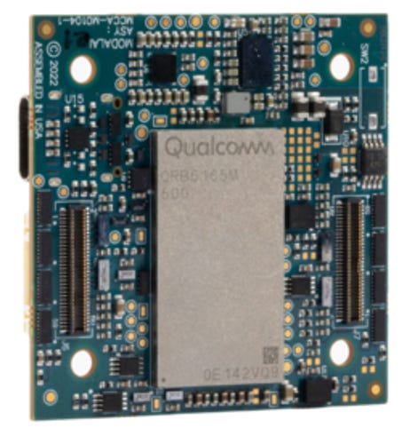
ModalAI rolled out its VOXL 2 Mini that features autonomy, communications, and power management. VOXL 2 Mini features the Qualcomm QCOM 0.00%↑ QRB5165 with 8 cores up to 3.091GHz, four MIPI-CSI image sensor inputs, pre-configured accessories, the company said.
The power from VOXL 2, coupled with perception sensors and a power management system, delivers obstacle avoidance, obstacle detection, and GPS-denied navigation. In addition, the company’s VOXL SDK enables developers looking to create, validate, test, and integrate their autonomous flight software into their small UAV solutions, the company said.
Contact: Lauren Young, ModalAI, lauren.young@modalai.com, www.modalai.com
ARway Integrates Platform with Microsoft HoloLens
ARway Corp. [ARWY] said it has started integrating its platform with the Microsoft HoloLens, with completion of the integration expected within the next 60 days. The company recently partnered with Magic Leap Glasses for the IPIN (Indoor Positioning and Indoor Navigation Market ) market.
Microsoft HoloLens is a mixed-reality headset that enables users to interact with virtual objects and holograms in a natural way using hand gestures, voice commands, and eye movements, the company said.
Contact: ARway, support@arway.ai, www.arway.ai
ATrack Launches In-Vehicle AI Solutions
ATrack Technology rolled out several new products including the AK500 multifunctional telematics gateway and AW500 smart AI camera that supports Advanced Driver Assistance Systems (ADAS). Other new products include the AS700 solar-powered asset tracker.
Contact: Chloe Wang, ATrack, chloe.wang@atrack.com.tw.
People
Combain Mobile AB has named Dadheech Girish as vice president of customer engagement.
VW to Fire Top Executives at Software Unit Cariad, Source Says.
Your partner in global employment
Over 1000 companies are hiring, paying, and taking care of their team members all over the world with Oyster’s all-in-one global employment platform.
Jobs
Sales Director. Septentrio.
Business Analyst. TomTom.
Senior Consulting Specialist. SBD Automotive.
Product Planning Director. SBD Automotive.
Open Roles. Taoglas.
Click HERE to Join our growing Location Business News LinkedIn Group!














I appreciate the LBN as it consistently provides valuable insights across a wide range of topics that are relevant to the audience. Thank you for consistently delivering a great read.