


NextNav Addresses the Critics: Our Approach Won’t Cost Taxpayers a Dime
Company says both space-based and terrestrial solutions are necessary to backup GPS. Paid subscriber content below, plus Globalstar's foray into two-way communications and People/Jobs.

Xona Grabs $4.65M AFRL Contract, Astrion Bounced from R-GPS
Xona Space Systems has received a contract with Air Force Research Lab to demonstrate resilient commercial PNT for DoD missions, the company said. The award, through a Space Technology Advanced Research fast track program, brings the company’s contracts to $20 million.
Xona will demonstrate its PULSAR satellite navigation service on several commercial user devices and in scenarios where GPS and other GNSS may be compromised, the company said. As part of the contract, Xona, which plans to launch a PULSAR satellite this summer, has partnered with QinetiQ, StarNav, and Locus Lock.
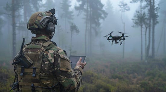
"This contract is enabling us to demonstrate not only the advanced capabilities these receivers can achieve with the PULSAR service, but also the utility of combining mass produced hardware with a securely controlled PNT service to support anything from small drones to large DoD systems, said Brian Manning, Xona CEO and co-founder, in a statement.
Astrion Canned from Resilient GPS Program…
While such companies as Xona are making inroads with the U.S. military, one company has been bounced from the U.S. Space Force Resilient GPS program. Following an initial design review, Astrion’s contract was discontinued, according to Defense News.
Last fall, the services’ acquisition element, Space Systems Command, awarded Astrion’s Astranis and Axient, L3Harris and Sierra Space, Astranis and Axient $10 million contracts to provide early plans for small, and low-cost, GPS satellites.
The R-GPS constellation may cost as much as $1 billion over the next five years. However, the satellites will cost much less than the larger Block IIIF GPS satellites.
Qualcomm Rolls Out Dragonwing for Embedded and Industrial IoT, Among Other Markets
Qualcomm QCOM 0.00%↑ this week announced its Dragonwing brand for enterprise solutions that include embedded and industrial IoT, cellular and networking infrastructure. While the announcement talked about the brand, and potential markets, it didn’t get into specifics about products.
Qualcomm says Dragonwing will be tailored to such industries as manufacturing, telecoms, retail, energy companies and supply chains. Some of the markets include drones and asset management in warehouses, to name a couple.
“As we continue to diversify, the core components of our platforms and solutions — AI, computing and connectivity — are relevant to more industries than ever before. From industrial robots to cameras, to industrial handhelds and drones, and more, this portfolio deserves a brand identity worthy of the technology innovation delivered across categories,” said Qualcomm CMO Don McGuire, in a blog post that primarily addresses the branding.
While Qualcomm’s Snapdragon is focused on such consumer markets as automobiles, handsets, wearables and PCs, Dragonwing will be centered on enterprise and industrial segments.
The company said it will showcase the brand at next week’s Mobile World Congress in Barcelona.
Vitality and Geotab Start a Behavioral Science Joint Venture at Geotab Connect
At Geotab’s Geotab Connect 2025 in Orlando this week, which touts itself as the largest fleet telematics conference, the company made several announcements, including a joint venture between the Canadian-based fleet giant and Vitality.
Vitality, which offers the Vitality Drive insurance program, will be integrated with Geotab’s telematics network of more than 4.7 million vehicles and AI-powered predictive analytics through a product called Geotab Vitality. The companies call their joint offering an “all-in-one behavior change platform” that incentivizes drivers with rewards.

“It's a game-changer for drivers who can gain access to personalized insights and rewards, and for fleets who can now cultivate a culture of recognition to retain and reward their most valuable drivers," said Sabina Martin, Geotab vice president, product management, in a statement.
Although the companies say Geotab Vitality “challenges the industry's traditional model of penalizing poor driving habits,” it will know about a driver’s habits. Overall, Geotab said it plans to integrate the new offering into Geotab Drive and the Geotab Safety Center later this year.
The companies say they are already seeing positive results from the joint venture, said Francois Theron, Vitality’s deputy CEO. “Through a Geotab Vitality pilot program, conducted over eight weeks, we’ve seen a 9 percent increase in overall average driving performance,” he said.
In other Geotab Connect news:
Geotab introduced Work Order Management and Fault Code Enrichment within its Maintenance Center to help fleet managers reduce downtime and manage maintenance cost, the company said.
Geotab has announced today it is expanding its connected vehicle platform with the Geotab Sustainability Center and EV Charge Monitoring.
The company launched GO Focus, an AI-powered safety sensor designed to help fleets enhance safety while addressing privacy and compliance concerns.
What’s a better venue than your own conference to launch products? In this case, Geotab rolled out Driver Risk Insights, an AI-powered enhancement within the Geotab Safety Center that provides fleet managers with visibility into individual driver risk factors.
Geodnet Gets $8 Million Investment, Partners With DroneDeploy
Geodnet has been an unconventional industry company since its inception and that hasn’t changed with an $8 million funding round of GEOD tokens by Multicoin, a crypto investment firm. Geodnet, which originated in the DePIN crypto world of startups, has doubled its project tokens in past year as the company’s location services grow.
At CES last month, company co-founder Mike Horton said that the company has grown its worldwide RTK GNSS network of base stations from zero to nearly 14,000 in three years. While Horton and three other co-founders come from high-precision GNSS company backgrounds, one of the founders has deep roots in blockchain and crypto technology.
DroneDeploy and Geodnet Foundation Partner
In other company news, DroneDeploy has partnered with Geodnet Foundation to allow DroneDeploy’s customers to have access to all 14,000 registered stations in the Geodnet network.

The access will give users access to drone survey, underground utility and documentation applications for construction, mining, energy and utilities. DroneDeploy said it would work with its customers to add additional Geodnet stations in areas with no coverage.
Weekly Location Industry News
News tip? Send them to kdennehy@driverlessreport.com. Go to www.locationbusinessnews.com for more news. Location Business News is looking for your company’s news, products and use cases to feature in each issue.
Top News:
🌒 LuGRE Sets Another Record: First GNSS Signals Detected in Lunar Orbit. “New record for LuGRE. On Feb. 19, the receiver successfully acquired and tracked signals from GPS and Galileo satellites even in lunar orbit, at 63 Earth radii, approximately 401,814 kilometers from Earth. LuGRE was developed in Italy by Qascom on behalf of the Italian Space Agency, in collaboration with NASA and scientific support from the Politecnico di Torino.”
👌 GPS Jamming, a Weapon in Hot and Hybrid Wars, Will Soon Be Obsolete. “Gyroscope-on-a-chip technology could soon enable us to navigate over long distances without GPS.”
🌍 Globalstar Details Next-Generation LEO Constellation in FCC Filing. “Globalstar GSAT 0.00%↑ detailed plans for its next-generation low-Earth orbit (LEO) constellation to support Apple AAPL 0.00%↑ satellite connectivity in a filing last week to the FCC.”
🏛 FCC Adopts Location-Based Routing for Wireless 911 Calls and RTT-to-911 Messages. “At its January 25, 2024, Open Meeting, the FCC adopted a Report and Order requiring all wireless carriers to implement location-based routing nationwide for wireless calls and real-time text (RTT) communications to 911 call centers. With this approach, 911 voice calls and RTT texts will be routed based on the location of the caller as opposed to the location of the cell tower that handles that call.”
📌 Geo Week Continues to Break Attendance Records; Sold Out Exhibit Hall Floor Largest in Event History. “The geospatial conference and tradeshow convened a record-breaking 3,222 professionals from more than 3,600 registrants, representing 49 countries. The sold-out exhibit hall was the largest in event history, featuring 215 exhibitor.s”
😮 TV-based PNT for 70 Percent of Americans in Three Years – Petition to FCC. “The National Association of Broadcasters (NAB) has asked the Federal Communications Commission to require television stations to start using the ATSC 3.0 standard for broadcast. The ATSC 3.0 signals will include the Broadcast Positioning System, a PNT service.”

Expert nationwide installation services for fleet technologies.
Maps:
🤷♂️ 'Gulf of Fragile Masculinity.' MapQuest Allows Users to Rename the Gulf of America. “MapQuest has not yet updated its map to reflect Trump's order. In what appears to be a joke, MapQuest is allowing online users to rename the gulf whatever they want.”
🚙 New Waze Update Enables Navigation on the Instrument Panel in BMW, Ford, Other Cars. “The latest Waze version enables the application to run on the instrument cluster in several cars, including select models from BMW, Ford, F 0.00%↑ and Polestar.”
🙂 what3words Acquires Swiftcomplete. “Adding Swiftcomplete to what3words means we are now able to offer a consolidated address entry solution.”
🗺 New Services in ArcGIS Location Platform. “Batch Geocoding, Last Mile Delivery service, Static Basemap Tiles service, Elevation service and new Static Map service coming soon in beta.”
🌎 TomTom Continues Partnership With Bee Maps. Editor’s Note: Not much made public about this partnership…and Bee Maps’ ongoing partnership with Mapbox.
😕 Google Maps Loses a Key Feature on CarPlay, Users Hope It's Just an Error. “One of the most important benefits of navigation apps is the added predictability, as they make driving to a destination safer by providing drivers with turn-by-turn guidance, traffic data, and hazard notifications. Additionally, most include a route preview screen that allows users to get prepared for the road by inspecting each turn and viewing traffic data before they hit the road. This ability has recently gone missing in Google Maps on CarPlay for a reason nobody can decrypt.”

Become a Paid Subscriber to Location Business News! Only $8 per month!
What Paid Subscribers get:
Full access to more than 200 Archived issues (stories, contacts, analysis).
A new subscriber-only Chat Board.
Access to Analysis and In-Depth Articles, plus People and Jobs.
Free entry to LBN-branded webinars and receptions at major trade shows (in development).
Steep Advertising Discounts for paid subscribers and Founding Members.
We average 30,000 views on our websites each month. Advertising starts at only $150 per issue. Please contact us at info@driverlessreport.com for more information…or go to our updated Advertising Page.
Connected and Autonomous Vehicles:
🤔 Elon Musk's DOGE Comes for Agency That Regulates Autonomous Vehicles. “Elon Musk’s Department of Government Efficiency is firing nearly half of a small government team that regulates autonomous vehicles, The Washington Post reported.”
🎖 RoboSense Reaches 1 Millionth Lidar Delivery Milestone. “RoboSense produced its one millionth lidar and delivered it to a humanoid robot company. [The company’s] sales in 2024 were 544,200 units, 95.52 percent of which were automotive lidars.”
🚘 Stellantis Has Developed a Level 3 Self-Driving Function. “Called STLA AutoDrive 1.0, the new hands-free system only works up to 37 mph, and Stellantis confirms it's not scheduled to go on the market for now.”
🚕 Thales Partners With Cubic to Launch Next-generation eSIM Solutions for Connected Vehicles. “Cubic will integrate Thales's eSIM technology to address the latest GSMA standards.”
💲 Oklahoma State University Awarded $4M for Autonomous Vehicle Research.
🤨 AAA: Fear in Self-Driving Vehicles Persists. “According to AAA’s latest survey on autonomous vehicles, 13 percent of U.S. drivers would trust riding in self-driving vehicles – an increase from last year, when this number was 9 percent. Despite this slight increase, six in 10 U.S. drivers still report being afraid to ride in a self-driving vehicle.”
👍 Autonomous Robotaxi Successfully Completes 75 mph Highway Testing. “Motional’s IONIQ 5 robotaxi just nailed high-speed tests, cruising at 75 mph.”
🚗 Tesla Rolls Out Advanced Self-Driving Functions in China. “Tesla TSLA 0.00%↑ has started offering advanced self-driving functions for its cars in China, including Autopilot on city streets, the company announced on Tuesday.”
😐 Pony AI Becomes First to Offer Robotaxi Operations Connecting Guangzhou’s City Center to Key Transportation Hubs. “Pony AI PONY 0.00%↑ announced the launch of paid robotaxi services from multiple locations in Guangzhou’s city center to Guangzhou Baiyun International Airport and Guangzhou South Railway Station.”
Fleet Telematics:
🚍 GearTrack and NexGen Delivering Comprehensive Asset Tracking Services. “GearTrack and NexGen Tech Solutions have announced a continued partnerships that combines GearTrack’s IoT-based asset tracking and protection technology with NexGen’s IT infrastructure expertise.
Financial:
✔ Ituran Presents Fourth Quarter & Full Year 2024 Results. “2,409,000 subscribers at year-end, adding 157,000 net, during the year at the high end of the guidance range. Record financial metrics across the board with revenue at $336.3 million, an increase of 5 percent year-over-year.”
✔ Innoviz Reports Fourth Quarter and Full Year 2024 Results. “Partnership announcements with Mobileye and NVIDIA position the Company to further scale business and pursue opportunities with new OEMs. Targeting 2025 revenues of $50 million to $60 million.”

The D-Day Visitor's Handbook: Your Guide to the Normandy Battlefields and WWII Paris by Kevin Dennehy and Steve Powers. The guidebook uses location technology from what3words to locate monuments, museums and other attractions. Get your guidebook today.
Weekly Product News
Send your news releases to kdennehy@driverlessreport.com. Go to www.locationbusinessnews.com for more news and an archive of stories.
U-blox collaborates with Intel on GNSS Timing Card, Earns ISO 27001Certification
Thalwil, Switzerland-based u-blox has announced a partnership Intel INTC 0.00%↑ to develop the M2-ZED-F9T GNSS timing card, which is tailored for Intel Xeon 6 SoC platforms. The M2-ZED-F9T timing card eases the implementation of Radio Access Networks (vRANs) supporting multiple radio access technologies, providing high-precision time synchronization, particularly as 5G adoption grows, the company said.
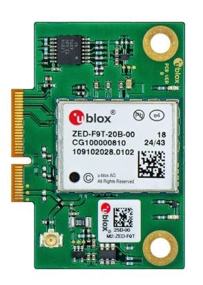
The company also said it achieved ISO 27001 certification. ISO 27001 certification is the international standard for information security management systems.
Contact: Sven Etzold, u-blox, 41 76 561 0066, sven.etzold@u-blox.com, www.u-blox.com.
Aeris Launches IoT Watchtower
Aeris has launched Aeris IoT Watchtower, an integrated security solution for cellular IoT. Aeris IoT Watchtower delivers enterprise IoT visibility and control to prevent IoT security breaches, significantly reduce the impact of any IoT security event, improve operational efficiency and ensure regulatory compliance, the company said. Swisscom Broadcast Service, which operates Switzerland’s most extensive LoRaWAN connectivity, is the first customer to leverage Aeris IoT Watchtower through Aeris’ longtime partnership with Swisscom. In addition, LB Technology, a North American fleet telematics provider, leverages Watchtower to monitor device traffic, detect anomalies and generate risk assessment reports to safeguard the sensitive data of its government and enterprise customers.
Contact: Gagan Aujla, for Aeris, prforaeris@bospar.com.
Glympse Joins the Mobile Satellite Users Association
Glympse has joined the Mobile Satellite Users Association to expand the reach of its location sharing and tracking technology into the satellite communications sector, the company said. MSUA represents such organizations as utilizing satellite connectivity, including sectors such as transportation, logistics, public safety, emergency response and field services. Glympse offers real-time tracking with a seamless user experience, the company said.
Contact: Rylee Swenke, Glympse, rylee@glympse.com, www.corp.glympse.com.
Pozyx Participates in Battlefield Casualty Project
Pozyx has announced its participation in TaMaCare, a project that focuses on battlefield casualty care technology. The company is using its Ultra-Wideband (UWB) localization technology to create a real-time digital twin of the frontline, providing medics with critical location and health data to enhance decision-making and response times, the company said.
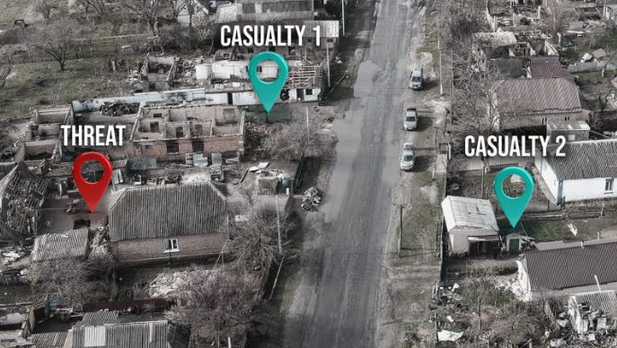
Others in the consortium include the Royal Military Academy’s 3D mapping experts;
and Ghent University (IPI Research Group), for image processing & computer vision.
Contact: Samuel Van de Velde, samuel@pozyx.io, Pozyx, www.pozyx.io.
STMicroelectronics Releases Satellite Navigation Receiver for Automotive and Industrial Applications
STMicroelectronics STM 0.00%↑ has introduced the Teseo VI family of GNSS receivers aimed at high-volume precise positioning use cases. For the automotive industry, Teseo VI chips and modules will be core building blocks of advanced driving systems (ADAS), smart in-vehicle systems, and safety-critical applications such as autonomous driving, the company said.
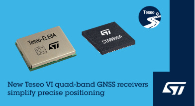
They have also been designed to improve positioning capabilities in multiple industrial applications including asset trackers, mobile robots for home deliveries, managing machinery and crop monitoring in smart agriculture, timing systems such as base stations, the company said. Teseo VI STA8600A and Teseo VI+, STA8610A each feature quad-band GNSS support (L1, L2, L5 and E6) with the unique ability to acquire and track only L5, the company said.
Contact: Alexis Breton, STMicroelectronics, 33.6.59.16.79.08, alexis.breton@st.com, www.st.com/teseo6.

Create a FREE ManyMe Account.
BeWhere Launches Asset Tracking Market Whitepaper
BeWhere has launched an industry whitepaper that discusses the integration of 5G and satellite technologies that will transform global asset tracking, the company said. The whitepaper, co-authored by GSMA Foundry and BeWhere, is titled Smart Logistics 2025: Designing Integrated 5G and Satellite Solutions for Global Asset Tracking. It says that the market for integrated satellite-IoT devices is projected to reach $10 billion in annual revenue by 2030, with 2-3 billion IoT devices primed for satellite integration out of an expected 38 billion total devices. Download the full 2025 report here.
Contact: Margaux Berry, BeWhere, (844) 229-4373 ext. 107, ir@bewhere.com, www.bewhere.com.
DZYNE Unveils Wearable Dronebuster
DZYNE Technologies has launched its Dronebuster Detect, Track, Identify, Mitigate (DTIM) Kit at the International Defence Exhibition and Conference (IDEX) in the UAE. Dronebuster features a wearable detection and identification capability, the company said.
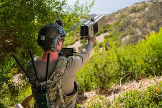
Dronebuster is the only American-made, electronic attack C-sUAS system available with an optional PNT capability to combat GNSS-enabled drones, the company said. This system is the only handheld system with a PNT Attack mode (spoofing) to counter autonomous drones, the company said.
Contact: DZYNE Technologies, info@dzyne.com, www.dzyne.com.
Juniper Systems Announces Galileo HAS-Enabled Geode GNSS Receiver
Juniper Systems has announced the Geode GNS3H multi-frequency receiver, which works with Galileo High Accuracy Service (HAS). Galileo HAS delivers free, worldwide positioning with 20 centimeter accuracy. The Geode GNS3H is now available and shipping worldwide, the company said.
Contact: Juniper Systems, www.junipersys.com.
AgEagle Aerial Systems Announces eBee VISION Application Software
AgEagle Aerial Systems UAVS 0.00%↑ has announced the release of its 2.1.0 eBee VISION application software. The software provides users with enhanced mapping capabilities and situational awareness measures, the company said. In addition to the eBee VISION’s HD real-time video surveillance capabilities, it now supports circular and grid mapping, allowing users to generate 2D or 3D maps in an external post-processing software, the company said.
Contact: AgEagle Aerial Systems, media@ageagle.com, wwwagealge.com.

Click HERE to Join our growing Location Business News LinkedIn Group!
NextNav Addresses the Critics: Our Approach Won’t Cost Taxpayers a Dime
Saying it would work with other industry stakeholders and the government to implement a backup to GPS, NextNav responded this week to recent criticism of its Federal Communications Commission proposal to reconfigure the lower 900 MHz band.
Keep reading with a 7-day free trial
Subscribe to Location Business News to keep reading this post and get 7 days of free access to the full post archives.