NextNav Files FCC Petition to Reconfigure 900 MHz Band for GPS Backup and 5G Broadband Services
Company wants to offer complimentary terrestrial PNT service...
NextNav NN 0.00%↑ filed a petition this week with the Federal Communications Commission (FCC) to reconfigure the 900 MHz band for a terrestrial complement and backup to GPS and provide 15 megahertz of low-band spectrum for use by mobile broadband networks.
As part of the petition, NextNav would enable a terrestrial positioning, navigation and timing (PNT) service to serve as a backup and complement to GPS. The company contends that its NextGen technology can provide PNT services without additional legislation and taxpayer dollars.
“We have the chance to do something exciting with our airwaves. This new vision for the lower 900 MHz band unleashes spectrum for essential PNT solutions as well as broadband – all while protecting licensed incumbent operations,” said NextNav CEO Mariam Sorond, in a statement. “In a time when spectrum is scarce, we have a solution to prioritize national security and public safety and free up spectrum for 5G. It’s a win for Americans and the U.S. economy.”
Specifically, NextNav filed the petition to offer a spectrum solution in the lower 900 MHz band (902-928 MHz band). The reallocated lower 900 MHz band could create access to 15 MHz of low-band spectrum for 5G services, said the company, which expects to partner with mobile network operators or others interested in commercial deployment in the band.
NextNav said it is already the main geographic licensee in the lower 900 MHz Band and has used its existing licenses to develop PNT expertise and products. In March, the company received regulatory approval to purchase an additional 4 MHz in the lower 900 MHZ band from Telesaurus Holdings and Skybridge Spectrum Foundation.
NextNav isn’t the only company looking at the 900 MHz band for opportunities. In published reports, Anterix, Ondas Networks and others are looking at the spectrum for communication services. The band has the ability to carry tremendous amounts of data.
In addition, members of the LoRa Alliance are using a slice of the 900 MHz band to develop IoT services, including asset management.
Expert nationwide installation services for fleet technologies.
TomTom Posts Operating Loss as Auto Sales Slow
Citing slow car sales in Europe and North America, TomTom [TOM2] reported a wider-than-expected loss in the first quarter.
"In the first quarter of 2024, revenue was comparable to the same quarter last year. While Location Technology revenue remained flat, we made significant progress in maturing our product offering and expanding our business development efforts,” said CEO Harold Goddijn, in a statement. “This quarter, we reached global coverage with TomTom Orbis Maps. With our new maps, we are extending our market reach, addressing a broader range of use cases and industries. We have expanded our sales funnel and are gaining momentum."
In November, European automobile manufacturers association ACEA forecast a slowdown in new car sales in the European Union, according to Reuters. This was a blow to TomTom as automotive markets constitute 60 percent of the company’s total sales.
The company posted a loss, before interest and taxes, of 4.9 million euros, or $5.2 million, for the first three months of 2024, versus a profit of 2.6 million euros last year.
Overture Maps Foundation Releases Beta of Its First Open Map Dataset
Overture Maps Foundation has announced the beta release of its global open map dataset. Developers can begin beta tests using Overture’s data and schema for commercial mapping applications and geospatial analysis.
While incremental changes are anticipated, Overture expects the data and schema to be substantially stable. Production releases are expected to begin in the summer, the foundation said.
“This beta release brings together multiple sources of open data, has been through several validation tests, is formatted in a new schema and has an entity reference system that allows attachment of other spatial data. This is a significant step forward for open map data by delivering data that is ready to be used in applications,” said Marc Prioleau, Overture’s executive director, in a statement.
Prioleau said that such foundation members as Meta $META are basing its map solutions on Overture data. Microsoft $MSFT is adopting Overture worldwide to add coverage on Bing Maps.
Esri is beginning to use Overture data to publish new 2D and 3D map layers in ArcGIS, and TomTom [TOM2] will be incorporating Overture data into their Orbis Maps.
The beta release includes five base layers, formatted in the foundation’s schema and assigned GERS IDs. New features include places of interest for 54 million pieces of information worldwide; 2.3 billion unique building footprints; a worldwide network of roads, footpaths and other travel infrastructure; administrative boundaries to include borders that are translated into 40 different languages; and contextual base layers that include land and water data and help complete display maps when needed, Overture said.
The D-Day Visitor's Handbook: Your Guide to the Normandy Battlefields and WWII Paris by Kevin Dennehy and Steve Powers. The D-Day Visitor’s Handbook includes everything you need to know to plan and make your visit to the site of the biggest seaborne invasion in history. This compact guidebook not only describes the most significant land invasion of World War II, but provides detailed battlefield maps and tours, identifies monuments and attractions, and locates museums and historical sites to make your planning easier and less stressful.
The guidebook uses location technology from what3words to locate monuments, museums and other attractions. Get your guidebook today!
China's Beidou Is Way Ahead of GPS, but Does It Matter?
COLORADO SPRINGS, Colo.—While panelists at the Space Foundation’s Space Symposium last week acknowledged that China’s Beidou satellite navigation constellation has more satellites, including low-Earth orbit (LEO) augmentation systems, the collective feeling was…so what?
In a future of positioning, navigation and timing panel (PNT), moderator Todd Simon, of Geospatial Alpha, asked panelists to comment on whether Beidou, with twice as many navigation satellites, three LEO PNT systems and 10 times as many monitoring ground stations, is a threat to the United States and its allies.
“It’s not about the numbers. You can pull the Chinese order of battle [to view] the number of ships, the number of soldiers, intelligence satellites and drones—they often have a greater number,” said Cordell DeLaPena, program executive officer for military communications and PNT, Space Systems Command. “Our focus is not about numbers, it’s about an approach that thickens our resistance between our coalition partners. China is on the other side of the world. We have to focus on maintaining a gold standard [GPS] in five critical areas. Anyone can put up numbers.”
Speaking for Galileo, Rodrigo da Costa, executive director European Union Agency for the Space Program, concentrated on the economic value of the system, while saying the European system worked well with GPS and other GNSS. “When we look at Galileo and GPS, the degree of interoperability is an added value to the users. It’s the value that is created—the element of economic use and value to our users,” he said.
Sheeva.AI Partners With Citroën
Sheeva.AI has announced in-vehicle payment technology through SheevaConnect product suite for the Stellantis’ Citroën C3 Aircross SUV AT. The in-vehicle payments technology will allow the new Citroën C3 Aircross AT owners to pay for fuel at 32,000 fueling stations across India, the company said.
“We’re very excited to see our technology come to life for Citroen drivers in India,” says Evgeny Klochikhin, CEO and founder of Sheeva.AI. “We want to enable a simpler, more secure customer experience for in-vehicle services by using precise vehicle location to activate and authorize payments at the point of service,” said Sheeva.AI founder and CEO Evgeny Klochikhin, in a statement.
Klochikhin said that other Sheeva.AI use cases, like parking and tolling, are coming soon for Citroën owners. Currently, Tysons Corner, Va.-based Sheeva.AI’s product suite is currently rolling out globally with over 2,000,000 service points, which includes fuel pumps, parking spaces and EV chargers that are mapped in the company’s database.
"While I can’t mention any partners or new use cases until the announcements are public, I’m confident you’ll see more news like this for the U.S. and European markets by the end of the year,” says Klochikhin. “That’s not just automakers but also energy retailers, EV charging networks, parking operators and other service providers.”
Other Location News
News tip? Send them to kdennehy@driverlessreport.com. Go to www.locationbusinessnews.com for more news and an archive of stories. Location Business News is looking for your company’s product use cases to feature in each issue. Send us five paragraphs and an image/photo for consideration. Include a contact name, phone, email and web address.
Top News:
🛰 Air Force To Get a Head Start On GPS, Target Tracking Efforts. “Details on the programs are classified, but one is a Space Force initiative to improve the resilience of GPS satellites and the second is an Air Force effort related to developing a battle management system for moving target indication, or tracking mobile targets from air and space, the Air Force said in an April 16 press release.”
🛩 How Israel's Defenses Repelled Iranian Missile and Drone Attacks. Financial Times: “That Israel was able to intercept the attack and prevent any loss of life is a testament to its “multi-layered” system of missile defences that includes the much-vaunted Aerial Defense Array.”
🙂 National Space-Based Positioning, Navigation, and Timing Advisory Board. Will meet April 24-25, 2024, at Antlers Hotel, Colorado Springs, Colorado.
⚡ LoRa Alliance Unveils LoRaWAN Development Roadmap.
😐 A Robotaxi Isn't Enough To Fix Tesla's Problems, Analyst Says. Here's What Elon Musk Needs To Do. “Wedbush analysts said Tesla TSLA 0.00%↑ pushing off a cheaper EV in favor of robotaxis would be a debacle.”
🌒 Inrix Identifies 1200+ Traffic Bottlenecks in Totality Path. “INRIX calculated more than 1250 traffic bottleneck locations within the [eclipse] path of totality, consisting of more than 2300 individual traffic jams. The average traffic jam within the path of totality stretched about 4.6 miles and lasted about 38 minutes.”
✈ Air Force Picks 'Resilient' GPS, MTI for Kendall's 'Quick Start' Push. “During a hearing of the Senate Armed Services Committee today, [U.S. Air Force Secretary] Kendall told lawmakers he has selected two projects to kick off work — one on “resilient” GPS capabilities and another on battle management for moving target indication (MTI).”
👍 Trimble CEO Rob Painter Discusses Trimble's Portfolio and the Role of Space in Software Applications.
😮 Most Resilient GNSS Receiver: Results From JammerTest in Norway.
Maps:
🙂 Waze Is About to Get the Biggest Update in Years, But Here Are 3 Features It Also Needs. “No matter what critics say, Waze keeps evolving, and the recent announcement about the biggest feature update in years proves Google GOOG 0.00%↑ still has no plan to merge it with Google Maps.”
🗺 Google Maps Navigation Just Got a Big 3D Upgrade. “Beta users now have the option to see 3D buildings during navigation.”
🌏 Waze and Google Maps Made GPS Car Navigators Free, but There Was a Time When That Wasn't the Case. And It Wasn't Exactly Cheap. Interesting history…but not really complete.
👏 Find More Sustainable Ways To Get Around, With New Maps and Search Updates. “In Maps, we’re launching a feature that shows public transit or walking suggestions next to driving routes, if travel times are comparable and practical.”

Webinar Promotion. Are you getting enough industry execs to sign up for your webinars? We’ve been promoting them for 15 years and know the ins and outs of webinar marketing. We will run a one-month campaign (with weekly reminders on our social media as the webinar gets closer). This includes ad placement in the newsletter, social media posts and a dedicated email blast to our subscribers. We really hit it hard on social media in the final five days as people always register at the last minute. Email us at info@driverlessreport.com for more information, or click here to view our one-page media kit.
Connected and Autonomous Vehicles:
🚕 Mercedes Joins Forces With Bosch To Develop Self-Driving Taxis. “The pact between the world's largest maker of premium cars and the world's largest automotive supplier forms a powerful counterweight to new auto industry players like Uber UBER 0.00%↑ and Didi which are working on self-driving cars with a business model geared toward clients who want to use rather than own cars.”
🏛 Robotaxi Regulators Say Tesla Hasn't Contacted Them About Plans Teased by Elon Musk. “Elon Musk said this month he plans to unveil a Tesla robotaxi this summer, but Arizona, California and Nevada regulators said Tesla hasn’t applied for permits it would need.”
😮 China's Didi Aims for 1 Million Robotaxis on Its Platform by 2030. “The company last month completed a more than $500 million fundraising round for the autonomous driving unit, led by SoftBank Group's Vision Fund 2.”
🤞 People Are Afraid of Self-Driving Cars — Can the Industry Change That? “The Autonomous Vehicle Industry Association (AVIA) represents Cruise, Waymo, Zoox, Motional, and others released something it’s calling its ‘TRUST Principles,’ which is basically an action plan for dealing with these negative headlines and spiraling poll numbers.”
👌 Waymo Begins Robotaxi Testing in Atlanta. “Over the next few months, Waymo will deploy a handful of cars driven manually by humans to gather mapping data and get familiar with Atlanta’s environment.”
🤔 Waymo, Cruise and Zoox Inch Forward Ahead of Tesla Joining Robotaxi Race. “Waymo, the autonomous driving child of Alphabet Inc., expanded its paid-fare service to Los Angeles this past Wednesday. It had already been offering free rides to Angelenos, but this was a major sign of confidence that the service is robust enough to charge for, adding a third metropolis to San Francisco and Phoenix.”
🤦♂️ 6 Waymo Robotaxis Block Traffic to San Francisco Freeway On-Ramp. Well, hell.
Financial:
✔ Sequans Secures Standstill Agreements on Existing Debt Maturities.
✔ Ituran Increases Dividend To 6% And Earns $35 Price Target From Barclay Analyst.
✔ BeWhere Reports 2023 Fiscal Year-End Results.
☹ Tesla Will Lay Off More Than 10% of Global Workforce: Read the Elon Musk Memo.
📈 Trimble Given "Overweight" Rating at Piper Sandler.
Location Industry Briefs
Send your news releases to kdennehy@driverlessreport.com. Go to www.locationbusinessnews.com for more news and an archive of stories.
AirIQ, KORE Wireless Canada Partner for M2M Connectivity
AirIQ has announced has signed an agreement with KORE Wireless Canada for wireless M2M connectivity throughout North America and Europe. Under the agreement, AirIQ will offer its customers access to a global networks, enabling GSM, GPRS and CDMA M2M applications, the company said. AirIQ said the deal will allow it to deliver advanced and reliable GPS technology and services to its customers.
Contact: AirIQ, www.airiq.com.
Verizon Connect Launches Equipment Asset Tracker in Europe
Verizon Connect VZ 0.00%↑ has announced the expansion of the company’s Equipment Asset Tracker (EAT) into Europe, including the United Kingdom, Ireland, Germany, France, Netherlands, Italy, Portugal, and Poland. The improved EAT is a Verizon Connect device that supports its Reveal and Fleet products, helping manage equipment data, such as status, location, productivity and health, while reducing theft and downtime for high-value and critical machinery, the company said.
EAT, launched in the U.S. and Canada in 2023, offers fleet managers visibility into device performance, allowing them to identify and address issues proactively, and even troubleshoot any device problems that may arise, the company said. Features include small size, wired and battery options, ping configurations, extended battery and others.
Contact: Tessa Giammona, Verizon, tessa.giammona@verizon.com, verizonconnect.com.
Point One Delivers Platform for Surveyors and Surveying Tool Manufacturers
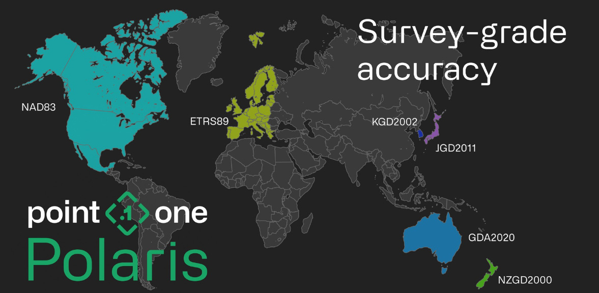
Point One Navigation has launched support for GIS product creators, surveyors, and construction professionals on the Polaris RTK Network. Polaris provides centimeter-accurate positioning across the United States, Europe, Great Britain, Australia, New Zealand and South Korea, the company said.

Point One is releasing automatic assignment of datums and base stations. By integrating with Point One Navigation’s GraphQL API, product creators can provision, manage, and observe devices in real time through a single API endpoint, the company said.
Contact: Mark Shapiro, for Point One Navigation, (619) 249-7742, mshapiro@srs-techpr.com, www.pointonenav.com.
Woolpert Implements CWOL, Rapid Ready Asset Lifecycle Management Solutions
Woolpert has completed the implementation of Cityworks Online (CWOL) for Metroparks Toledo. Developed in Trimble’s TRMB 0.00%↑ Cityworks software, the GIS-centric asset management system provides park-specific asset data structures and workflows designed to support and improve operations and planning, the company said.
In other company news, Woolpert has completed its Rapid Ready implementation of the Cityworks asset management system for West County Wastewater (WCW). The utility provider services more than 35,000 residents and businesses throughout West Contra Costa County.
Contact: Lynn Rossi, Woolpert, 312-837-2017, lynn.rossi@woolpert.com, www.woolpert.com.
Geotab: 87% of Transportation Fleets Anticipate Rising Business Costs
Geotab has conducted a survey of U.S. fleet professionals, with Bobit Research Group, that says transportation companies will see 87 percent increases in their business costs throughout 2024. However, 42 percent of fleet professionals believe customers will demand more fleet sustainability initiatives in the next 1-3 years in order to continue doing business with them, the survey said. Approximately 39 percent indicate new vehicles as the largest portion of their costs, while 28 percent report vehicle maintenance, and 15 percent report fuel costs as the biggest driver of cost, the survey said. The company also launched its report, "Taking Charge: On the road to the EV Future" on fleet electrification.
Contact: Geotab, www.geotab.com.
BlackBerry Announces Collaboration with AMD
At Embedded World, BlackBerry BB 0.00%↑ partnered with AMD to integrate technology for robotic systems in industrial and healthcare markets. The platform combines BlackBerry QNX, including a QNX Software Development Platform (SDP), with hardware solutions powered by the AMD Kria K26 SOM. The combination enables sensor fusion, high-performance data processing, real-time control, industrial networking, and reduced latency in robotic applications, the company said.
Contact: BlackBerry, (519) 597-7273, mediarelations@blackberry.com.
Create a FREE ManyMe Account.
MerlinTPS Demonstrates at PNTAX
MerlinTPS tested GPS satellite independence during its first remote location tests. The company’s primary intent was to prove its Terrestrial Positioning System (TPS) could survive and thrive in the onslaught of electromagnetic radio frequency interference produced at the PNT Assessment Exercises, or PNTAX, in August 2023. MerlinTPS works independent of GNSS denial efforts and relies on existing signals of opportunity from broadcast radio, which are much harder to overpower and nearly impossible to spoof, the company said.
Contact: Matt Greenfield, for MerlinTPS, mgreenfield@uproarpr.com, www.merlintps.com.
Marelli Launches ProConnect
Marelli has launched ProConnect, with infotainment and 5G telematics, at Auto China in Beijing. ProConnect is targeted for the China market where many OEMs are integrating cockpit and telematics functions for entry and mid segment vehicles, the company said.

Powered by MediaTek's MT8675 System on Chip (SoC), ProConnect manages both the instrument cluster and the infotainment system, supporting up to six displays and twelve cameras, while providing 5G Release 15 telematics performance, the company said.
Contact: Marelli, www.marelli.com.
RF Code and Schneider Electric Partner
RF Code has partnered with Schneider Electric to integrate the company’s software-enabled wire-free hardware with Schneider Electric’s EcoStruxure IT. The outcome of this integration eliminates manual processes and ensures 99 percent accurate asset tracking and chain of custody data in real-time, the company said. RF Code’s solution includes a wire-free sensor technology integrated with RF Code CenterScape software.
Contact: David Haut, RF Code, dhaut@rfcode.com, www.rfcode.com.
Hexagon-NovAtel Announces 7.09.01 and 7.09.02 Firmware
Hexagon-NovAtel has the release of 7.09.01 and 7.09.02 firmware to provide enhancements to precise point positioning (PPP) accuracy and availability for ionospheric scintillation on all OEM7 receiver boards, enclosures and SMART Antennas. Ionospheric scintillation refers to rapid fluctuations in GNSS signal strength and phase due to localized irregularities in the electron density of the ionosphere resulting from solar activity, the company said. Scintillation adversely affects GNSS positioning, particularly around the geomagnetic equator after local sunset, the company said.
Contact: Hexagon-Novatel, www.novatel.com/contactus/dealer-network.
HID Grabs Gartner Magic Quandrant Recognition
HID Global has been named a Gartner leader in its 2024 Magic Quadrant for Indoor Location Services. HID’s recently acquired GuardRFID and Connexient to bolster its location services portfolio. HID uses location technology for people workflow, infant security, asset tracking and other use cases.
Contact: Matt Winn, HID Global, mwinn@hidglobal.com, www.hidglobal.com.
JAVAD GNSS Gets Growth Partnership Award
JAVAD GNSS has won the 2023 Build + Elevate Growth Award from the BE NKY Growth Partnership, the economic development company for Northern Kentucky. The company’s research and development is based in Kentucky.
Contact: Gary Walker, JAVAD GNSS, (408) 770-1770, sales@javad.com, www.javad.com.
People
Charles “Chip” Lebovitz has joined ORBCOMM as chief of staff and director of strategic initiatives.
RoadFlex has announced that Rush Akin has been named chief revenue officer.
Woolpert has hired William Marbell to serve as geospatial program director in Africa, Latin America, and the Caribbean. Marbell worked for 15 years with Trimble. The company also hired Kristi Norman as market director.
Iain McNicolIain has started a new position as director, spatial data analytics and engineering at HERE Technologies.
Jeff Waggamon has joined Woolpert's transportation team as project manager.
Maxar has named Hayley Waterton as senior marketing manager of international government.
Jobs
Director, Product Management (Auto BU). Qualcomm.
Principal 5G PNT Architect. NextNav.
Transportation Specialist - BIL. Department of Transportation.
Field Sales Representative. Woolpert.
Click HERE to Join our growing Location Business News LinkedIn Group!


