Qualcomm Supports NavIC L1 Signals in Commercial Chipset Platforms
First commercial devices supporting NavIC L1 Available in 2025…
Qualcomm Technologies $QCOM this week announced its support for the recently launched L1 signals of India’s Navigation and Indian Constellation (NavIC) in select chipset platforms.
The company, which is working with the Indian Space Research Organization (ISRO), said the collaboration will accelerate the adoption of NavIC and enhance geolocation capabilities for use in mobile, automotive and IoT applications.
Qualcomm will offer a solution based on its Location Suite, which supports as many as seven satellite constellations concurrently. These include all of NavIC’s L1 and L5 signals for location, faster time-to-first fix position acquisition and location-based services, the company said.
“We continue our work with ISRO to further accelerate NavIC’s adoption and to enable more advanced geolocation applications with the latest NavIC technologies,” said Francesco Grilli, Qualcomm’s vice president, product management, in a statement.
Qualcomm said that additional support for the NavIC L1 signals will be available in select chipset platforms starting in the second half of 2024. However, the company said that commercial devices supporting NavIC L1 signals won’t be available until the first half of 2025.
The company plans to demonstrate its support for the NavIC L1 signals in the Snapdragon Mobile Platforms at its Qualcomm Innovation Forum event in Bengaluru this month.
Expert nationwide installation services for fleet technologies
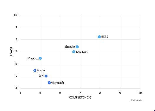
Omdia Ranks HERE as Top Location Platform in 2023
HERE Technologies came out as the top provider in Omdia’s 2023 Location Platform Index. The index evaluates major digital mapping and location technology vendors including HERE, Google $GOOG, TomTom [TOM2], Mapbox, Esri, Apple $AAPL and Microsoft $MSFT.
The report gave kudos to HERE’s electric vehicle (EV) efforts. The HERE EV Charge Points product includes data on more than 1 million EV connectors across 102 countries, the report said.
In addition, Omdia said HERE HD Live Map is used by Mercedes-Benz and BMW in their SAE Level 3 automated driving systems. Overall, more than 180 million vehicles are equipped with HERE maps, the report said.
In the report, Omdia highlights HERE's commitment to UniMap, which the company launched at CES in January. “HERE’s UniMap demonstrates the company is readily embracing the next major technological paradigm shift, AI," said Shobhit Srivastava, Omdia senior principal analyst.
However, the report said that HERE has a few challenges in that it needed to push for higher consumer adoption of its HERE WeGo product. Such competitors as Google Maps have ramped up marketing and increased advertising for the segment, the company said.
The D-Day Visitor's Handbook: Your Guide to the Normandy Battlefields and WWII Paris by Kevin Dennehy and Steve Powers. The D-Day Visitor’s Handbook includes everything you need to know to plan and make your visit to the site of the biggest seaborne invasion in history. This compact guidebook not only describes the most significant land invasion of World War II, but provides detailed battlefield maps and tours, identifies monuments and attractions, and locates museums and historical sites to make your planning easier and less stressful.
The guidebook uses location technology from what3words to locate monuments, museums and other attractions. Get your guidebook today!
Taoglas provides GNSS Antenna for Ireland’s First Satellite
Taoglas has played a pivotal role in the launch of Ireland’s first satellite, Educational Irish Research Satellite 1 (EIRSAT-1). Developed at University College Dublin (UCD), with the support of the European Space Agency's Education Program, EIRSAT-1 launched this month aboard a SpaceX Falcon 9 rocket.
As part of the project, Taoglas’ GPS/Galileo patch antenna was used to locate EIRSAT-1’s scientific measurements are recorded in orbit, the company said. In addition, Taoglas provided cable assemblies that can endure harsh space environments.
"We jumped at the chance to contribute our technology to the students and researchers in UCD behind this project, and as a UCD alum myself, I am delighted to see the end result," said Dermot O'Shea, Taoglas CEO, in a statement. "Aerospace is a vast frontier for GNSS antenna applications. The launch of EIRSAT-1 signifies a remarkable achievement for Ireland and highlights the nation's capabilities in space research and technology.”
EIRSAT-1 will carry three payloads into low-Earth-orbit around the Earth, including a gamma-ray detector, a space materials characterization experiment, and a spacecraft control testbed.
Taoglas' antenna technology balances functionality, durability, and reliability into quality solutions precision-engineered to endure the harshest environments. Its GPS antenna meets the stringent requirements of space exploration and optimizes space on board, a critical consideration for a satellite the size of EIRSAT-1.
In other space news:
Airbus has announced that full production has begun on the six Galileo Second Generation (G2) satellites at its facilities in Friedrichshafen, Germany. The production, which began after the arrival of the first satellite Flight Model structure from Beyond Gravity in Zurich, will see initial panels dispatched
to other company sites before final integration and testing, the company said.
PlanetiQ has launched its fourth generation Radio Occultation (RO) measurement satellite, GNOMES-4, aboard a SpaceX Falcon 9 rocket from Vandenberg Space Force Base in California. GNOMES-4 is equipped with the Pyxis weather sensor to offer GNSS-RO data for weather forecasting and atmospheric research.
Spire Global $SPIR was awarded a space services contract by Lacuna Space to build and launch six satellites carrying Lacuna’s IoT payload and antenna. The company said it could have the opportunity to scale the constellation to dozens of satellites.
Dollar Flight Club is offering their Lifetime Membership for $129 (usually $1,690) for the next 24 hours. Lifetime Members get up to 90% off all flights for life! Fly roundtrip to Paris from $320, Hawaii from $197, and more. Get 93% off lifetime or try for free now.
Other Location News
News tip? Send them to kdennehy@driverlessreport.com. Go to www.locationbusinessnews.com for more news and an archive of stories.
Top News:
☹ Broadcom Will Reportedly Cut 1,267 Employees at VMware's Palo Alto Office. “Broadcom $AVGO will reportedly cut employees at VMware’s Palo Alto office, following the completion of the $61 billion acquisition of the software player company, which finally closed last month after facing various regulatory hurdles.”
💲 Foretellix Raises $85M To Build and Test Scenarios for Self-Driving Systems. “Foretellix, which builds verification and validation solutions to test the full range of driver assistance and autonomous systems that are coming out on the market, has closed its Series C at $85 million.”
✈ Airline Industry To Meet in January Over GPS Spoofing Spike. “Global aviation industry leaders will meet in January to discuss safety concerns around increased GPS interference by cyberattackers steering planes off course, an International Air Transport Association executive said on Wednesday.”
🤔 G+D, PassTime, Sony, AT&T Launch Major iSIM Deployment. “PassTime wanted to develop its next-generation GPS locater with added features.”
🌍 Globalstar Introduces GSatSolar to Its Industrial IoT Asset Tracking Portfolio.
👍 T42 Supplies Satellite IoT to 50 Shipping Firms. Sateliot has announced a deal with freight software and analytics company t42 to deploy thousands of 5G-IoT sensors in shipping containers.”
Maps:
🎅 Screw “Immersive Views”. A Santa Claus List for Mapping Apps. “Missive to the big boys: Forget immersive views. Create something more useful. It’ll cost you a lot less and your users might actually appreciate it.”
🤨 Here's Proof Apple Maps Can't Be Considered a Google Maps Killer Yet. “Apple AAPL 0.00%↑ still needs weeks, and sometimes months, to update Apple Maps, giving users no option but to switch to Google Maps for up-to-date information.”
🤷♂️ Back to Waze: The New Google Maps Is Ugly, Cold, and Impossible to Use. “The updated color scheme was supposed to make Google Maps feel more natural and straightforward, but the search giant achieved the opposite in many ways.”
😦 Google Maps' Latest Updates Finally Pushed Me to Apple Maps. “Google GOOG 0.00%↑ says the update makes its map “reflect the real world even more accurately.” That may be true, but the new color scheme is a disaster.”
🗺 Enhancing The Fan Experience: How Indoor Mapping Technology Is Changing The Game. Brian Parks, Americas general manager at MapsPeople outlines how indoor mapping technology can elevate fan experiences in stadiums.
Reach nearly 14,000 subscribers and 100,000 more via social media by advertising in Location Business News!
We can promote your webinar, service or product to a focused group of industry executives. Email us at info@driverlessreport.com for more information, or click here to view our one-page media kit.
Autonomous and Connected Vehicles:
💰 Softbank Takes 51% Of Cubic Telecom for $513M To Drive Into the Connected Car World.
🙁 GM 'Focused on Righting' Ship at Self-Driving Cruise Unit-CEO.
😉 Waymo Is Full Speed Ahead as Safety Incidents and Regulators Stymie Competitor Cruise. “Waymo has been operating in some capacity since 2009, but for years, Cruise has seemed to be competing neck-and-neck -- now, after a barrage of safety concerns and incidents in recent months, the self-driving car landscape looks starkly different.”
🚛 Where Are All the Robot Trucks? “The promised wave of autonomous big rigs never materialized. But 2024 could prove to be a pivotal year for the technology.”
😯 Another Blow for Self-Driving Trucks as Former Industry Leader Abandons the US. “About 150 U.S. workers, or 75 percent of staff in the country, will be laid off. The remaining 50 workers will wind down TuSimple’s U.S. operations.”
🛺 New Zealand Electric AV Shuttle Maker Moves HQ to California. “The (Riverside, Calif.) city council voted unanimously Tuesday, Nov. 28 to approve Ohmio's plan to move its home base to Riverside.”
Drones:
Connect your teams in ClickUp.
Turn TBD into EOD with the world’s most powerful productivity tool. With ClickUp, you can: Automate sprints and routine tasks, Streamline communication in one Workspace, Recover cash spent on multiple work apps! Sign up and switch to ClickUp in minutes!
One tool does it all—ClickUp offers all the features you need in one platform: Tasks, Docs, Whiteboards, Dashboards, Goals… and more! Switch today to explore our 100% customizable features!
Location Industry Briefs
Send your news releases to kdennehy@driverlessreport.com. Go to www.locationbusinessnews.com for more news and an archive of stories.
Nearmap Acquires Betterview
Nearmap has acquired Betterview, a property intelligence and risk management platform in the insurance industry. The acquisition will “reinforce the company’s position as a leading source of imagery intelligence, data and solutions,” Nearmap said. The companies will offer solutions to allow the development of insurance solutions and capabilities. Financial details were not disclosed.
Contact: Taylor Cenicola, Nearmap, taylor.cenicola@nearmap.com, www.nearmap.com.
Digital Matter’s Oyster3 Certified on T-Mobile’s Network
Digital Matter’s Oyster3 IoT asset tracker has been certified on the T-Mobile $TMUS network. Oyster3, which features GPS tracking and a 10-year battery life, is not compatible with the T-Mobile network in the United States.
Digital Matter also announced that it has partnered with IoT Squared to market tracking solutions in the Saudi Arabia market. The company also said its Barra range trackers are now integrated with Wialon’s tracking solutions.
Contact: Shay Kettner, Digital Matter, shay@digitalmatter.com, digitalmatter.com.
Geotab Launches Solar Tracker
Geotab has launched the TT600 series solar tracker by PUI on the Geotab Marketplace in Australia and New Zealand. The tracker offers fleet managers detailed tracking information for such assets as trailers, containers, and generators, the company said.
The solar-powered asset tracker TT600 series uses GPS-based tracking to provide insight into asset usage and location via the MyGeotab platform. PUI, with100 employees worldwide, manufactures IoT hardware devices and asset monitoring solutions.
Contact: Hanna Corrente, Geotab, pr@geotab.com, www.geotab.com.
HERE and Murata Manufacturing Partner
HERE and Murata Manufacturing are partnering on a traffic management system in Jakarta, Indonesia. HERE map and traffic data are integrated with Murata’s traffic counter system to allow city workers to manage traffic, the company said.
By integrating map and traffic data from HERE with Murata’s traffic counter system that uses lidar technology, city authorities in Jakarta now have insights into traffic patterns – including real-time traffic data such as vehicle count, classification, flow direction and speed; peak traffic hours and popular travel routes, the company said.
Contact: Camy Cheng, HERE Technologies, 65 9088 4127, Camy.cheng@here.com, www.here.com.
INRIX Announces Compass for Traffic Management
INRIX has launched INRIX Compass, which features AI technology for traffic management. Harnessing INRIX’s 50-petabyte data lake and Amazon Bedrock’s AI capabilities, Compass delivers insights into transportation issues, the company said.
The company also launched INRIX Mission Control, which offers real-time insights across all road types/classes by combining traffic flow data with real-time roadway alerts, the company said.
Contact: INRIX, www.inrix.com.
Kodiak Launches First Autonomous Military Prototype Vehicle
Kodiak Robotics has unveiled its first autonomous test vehicle for the U.S. Department of Defense (DoD). The vehicle, a Ford F-150 fitted with Kodiak's autonomous system, the Kodiak Driver, contains both the autonomy hardware and software required to operate a military ground vehicle, the company said.

The Kodiak Driver-equipped vehicle is designed to handle military environments, diverse operational conditions, and areas with degraded GPS, as well as off-road variables like rocks, dust, mud, and water, the company said. The Kodiak Driver also provides the Army the ability to remotely operate vehicles when necessary, the company said.
Contact: Kodiak Robotics, www.kodiak.ai.
Trimble Contributes Inertial Navigation Solutions to the Indian Institute of Technology
Trimble $TRMB has partnered with the Indian Institute of Technology in Kanpur (IIT Kanpur) to support uncrewed aerial vehicles (UAV) to be offered by the Department of Aerospace Engineering. Trimble has contributed direct georeferencing (DG) products for UAV survey and mapping to the institution.
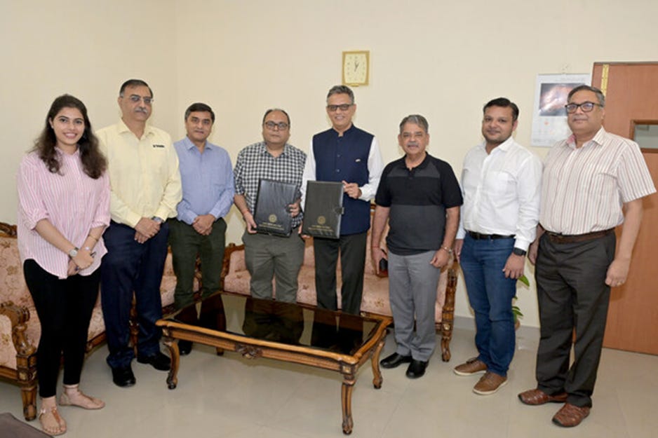
This includes a suite of Applanix board sets and the supporting processing software. In addition to the hardware and software, Trimble will also provide training and support to educate the UAV engineering team on how best to integrate and use the products within their teaching curriculum, the company said. India is projected to be the fastest growing UAV market by 2025, according to a recent report by PricewaterhouseCoopers.
Contact: Trimble, www.trimble.com.
Create a FREE ManyMe Account.
Quectel Launches Smart Modules
Quectel Wireless Solutions has launched its SG520B series of 5G Sub6Ghz, Wi-Fi 6E and Bluetooth smart modules. The modules feature Qualcomm’s $QCOM QCM4490 64-bit octa-core processors.
The smart modules offer Bluetooth 5.2 and the option of a GNSS receiver. Use cases include smart gateways, customer precise equipment, Mi-Fi devices and point of sale terminals.
Contact: Quectel, media@quectel.com, www.quectel.com.
Powerfleet Named ABI Research Top Innovator
Powerfleet $PWFL was named a top innovator in ABI Research's Commercial Video Telematics Competitive Ranking. The ABI study ranked Powerfleet as a top innovator based on its solutions, user experience, key use cases, cameras and sensors, driving monitoring systems, and reporting and analytics capabilities, the company said. In addition, Powerfleet was recognized for its video solutions and its device-agnostic fleet intelligence platform Unity.
Contact: Andrea Hayton, Powerfleet, (610) 401-1999, ahayton@powerfleet.com, www.powerfleet.com.
UP42 Partners With OroraTech
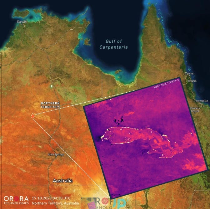
UP42 has partnered with OroraTech for high-resolution thermal-infrared imagery. OroraTech will join UP42's marketplace of nearly 80 data and processing partners.
OroraTech offers on-demand tasking for real-time data access from anywhere in the world with 400-kilometer coverage and 200-meter resolution on a daily basis, the company said.
Contact: Viviana Laperchia, UP42, viviana.laperchia@up42.com, www.up42.com.
Chat with your enterprise databases using secure generative AI and empower business users in your team to do their own data analyses in seconds.
People
Phunware appoints Jeremy Kidd as senior vice president of sales and marketing.
Jobs
Vice President of Sales, GNR.
HR Generalist. TomTom.
VP of Customer Success. Pointr.
Enterprise Sales Director. Pointr.
Inside Sales Representative. EROAD.
Automotive Customer Program Manager. Swift Navigation.
Click HERE to Join our growing Location Business News LinkedIn Group!


