Space Force Awards Contracts for R-GPS Program
The Space Force wants to augment GPS with small sats, but a U.S. House subcommittee says they may not provide much resilience
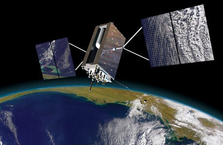
The U.S. Space Force’s Space Systems Command has awarded four contracts to Astranis, Axient, L3 Harris LHX 0.00%↑, and Sierra Space to produce design concepts for Resilient GPS, or R-GPS. The initiative, part of the Space Force’s Lite Evolving Augmented Proliferation, will attempt to provide resilience to military and civil GPS communities by augmenting the regular GPS constellation with small satellites.
These small sats will transmit a core of widely-used GPS signals, the Space Force said. In addition, the Space Force said the decision to pursue R-GPS came when recent studies recommended an additional “fleet of small GPS satellites.”
While the Space Force did not disclose the value of these awards, it has told Congress that the program will cost about $1 billion over the next five years. The Space Force has moved $40 million in fiscal year 2023 funding to support the program, with $77 million more requested in 2025.
However, as Location Business News reported, the U.S. House Appropriations defense subcommittee says they aren’t sold on the Space Force’s plan to use R-GPS satellites to increase resiliency. Before they recommended not to fund the $77 million that the Space Force requested in DoD’s fiscal 2025 budget request, the committee said that 20 proposed small sats transmitting core GPS signals may not provide much signal resilience.
The Space Force is using a Quick Start authority from National Defense Authorization Act, which to award the contracts in less than six months, which is faster than traditional space programs that can take years.
This R-GPS award is the first of three phases to produce up to eight R-GPS satellites available for launch as soon as 2028, the Space Force said. The R-GPS program aims to launch as many as eight satellites via LEAPs, which are intended the to build on previous sats by adding more capabilities, the Space Force said.
Expert nationwide installation services for fleet technologies.
U.S. Government Seeks to Ban Chinese, Russian Connected Car Tech
The U.S. government, specifically Department of Commerce regulators, are issuing a notice of proposed rulemaking (NPRM) that would prohibit the sale or import of connected vehicles equipped with communication and automated vehicle technology from the People’s Republic of China (PRC) and Russia.
This decision could ban testing by Chinese robotaxi companies who are currently testing autonomous vehicles on U.S. highways. As part of this ban, the Biden administration also would prohibit vehicles with Chinese-made wireless communication modules
Location Business News reported that there is growing national security concern over the data Chinese robotaxi firms are gathering in the United States through self-driving vehicles equipped with cameras, lidar, microphones and other sensors. Chinese-owned companies Pony.ai, WeRide, Didi Research America, Baidu's Apollo, and AutoX have logged more than 1.8 million miles in California.
The potential ban hasn’t stopped such U.S. companies as Uber UBER 0.00%↑ from partnering with such Chinese autonomous vehicle companies as WeRide. Uber and WeRide announced this week that they are partnering to bring autonomous vehicles to the Uber platform, beginning in the United Arab Emirates.
In addition to TikTok, the Biden administration has been coming down on Chinese connected vehicles as part of a growing trade war. In March, the Commerce Department issued an advance notice of proposed rulemaking (ANPRM), which sought public comment on potential national security risks associated with technologies used in connected vehicles. The Biden administration, in May, directed an increase from 25 percent to 100 percent on tariff rates for Chinese electric vehicles.
Overall, the Commerce Department has found that Chinese connected vehicles have the opportunity to “collect and exploit sensitive information.” The federal agency said that this collection includes information on a specific geographic area or critical infrastructure to “present opportunities for malicious actors to disrupt the operations of infrastructure or the vehicles themselves.”
Not only would the rule prohibit the sale of certain connected vehicle systems designed and manufactured by the PRC or Russia, but would cover components connecting the vehicle to Bluetooth, cellular, satellite, Wi-Fi modules and automated driving systems. However, Commerce said there would be exceptions to include small vehicle manufacturers who would be disrupted.
The government said the software prohibitions effect for model year 2027; the prohibitions on hardware would take effect for model year 2030; and Jan. 1, 2029, for units without a model year.
The D-Day Visitor's Handbook: Your Guide to the Normandy Battlefields and WWII Paris by Kevin Dennehy and Steve Powers. The D-Day Visitor’s Handbook includes everything you need to know to plan and make your visit to the site of the biggest seaborne invasion in history. This compact guidebook not only describes the most significant land invasion of World War II, but provides detailed battlefield maps and tours, identifies monuments and attractions, and locates museums and historical sites to make your planning easier and less stressful.
The guidebook uses location technology from what3words to locate monuments, museums and other attractions. Get your guidebook today!
Intergeo 2024 Features UAV, V2X and Machinery Technology Launches
STUTTGART, Germany— This week’s Intergeo 2024 conference, known for years as a high-precision survey show, has become a showcase for autonomous machinery, Vehicle to Anything (V2X), and particularly, UAVs.
At Integeo, Trimble TRMB 0.00%↑ announced the launch of premium direct georeferencing solutions, the Trimble APX RTX portfolio, for mapping sensors on uncrewed aerial vehicles (UAVs). The company said OEMs and drone payload integrators can fly around the clock to deliver map products with these solutions.
The company said its CenterPoint RTX, integrated with georeferenced solutions, enables real-time and post-mission direct georeferencing of camera, LiDAR and hyperspectral mapping sensors on UAVs. The Trimble APX RTX is embedded with GNSS inertial hardware that delivers real-time positioning and highly accurate roll, pitch and heading measurements, the company said.
Quectel Wireless Solutions launched the first quad-band GNSS module, the LG290P, and the Quectel RTK Correction Service at Intergeo. The LG290P GNSS module features RTK availability in challenging environments, the company said. It is suited for such applications as precision agriculture, robotic lawn mowers, surveying and personal robots.
The company’s new RTK Correction Services offer centimeter-level positioning accuracy that “outperforms traditional GNSS solutions.” By partnering with RTK correction service providers, Quectel can deliver tailored solutions optimized for specific applications and locations to existing customers, the company said.
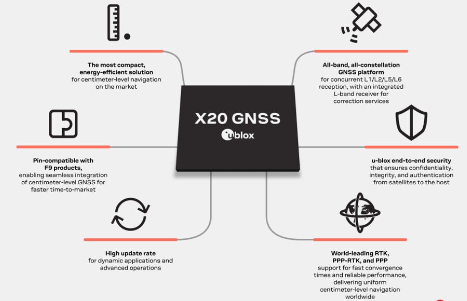
At Intergeo, u-blox, building on its F9 high-precision platform, launched its X20 GNSS platform for automotive, industry automation, emerging industrial markets and network information and time sync. X20 is an all-band (L1/L2/L5/L6) platform with an integrated L-band receiver.
In other Intergeo news:
Point One Navigation founder & CEO Aaron Nathan talked about “Effortless
RTK: Turning Challenges into Profits.”
Trimble and Worldsensing have announced a solution for 3D ground and structural movement monitoring. It integrates Trimble’s 4D Control (T4D) software with the Trimble GNSS Meter, powered by Worldsensing.
Eeve rolled out the Willow robot, an intelligent lawn mower robot that cuts grass, manage weeds and acts as security guard at night.
The Ekin X Spotter was displayed—and features a smart traffic enforcement system that performs automatic licence plate recognition and speed violation.
MIKROE’s GNSS RTK 4 Click was launched. It features compact add-on board designed for high-precision GNSS positioning and navigation
The Systork’s Linnet, an RTK multi-band module facilitating centimeter level navigation, was launched.
ZCS showcased its Twenty 29, 4.0 – 4.36 – 4.50 Elite RTK lawnmowers.
The D-Day Visitor's Handbook: Your Guide to the Normandy Battlefields and WWII Paris by Kevin Dennehy and Steve Powers. The D-Day Visitor’s Handbook includes everything you need to know to plan and make your visit to the site of the biggest seaborne invasion in history. This compact guidebook not only describes the most significant land invasion of World War II, but provides detailed battlefield maps and tours, identifies monuments and attractions, and locates museums and historical sites to make your planning easier and less stressful.
The guidebook uses location technology from what3words to locate monuments, museums and other attractions. Get your guidebook today!
Other Location News
News tip? Send them to kdennehy@driverlessreport.com. Go to www.locationbusinessnews.com for more news and an archive of stories. Location Business News is looking for your company’s product use cases to feature in each issue. Send us five paragraphs and an image/photo for consideration. Include a contact name, phone, email and web address.
Top News:
🛰 U.S. Eyes Geostationary Orbit for Next-Gen GPS. “The Navigation Technology Satellite-3 (NTS-3), developed by the U.S. Air Force Research Laboratory, aims to test advanced technologies for future GPS and satellite navigation systems. Its launch, potentially before year’s end, hinges on the certification of United Launch Alliance’s Vulcan rocket.”
🤞 Last Beidou-3 Satellites Sent Into Orbit To Test Tech for Next-Gen Navigation System. “China has launched the last two satellites of its third-generation BeiDou navigation system, which will test new hardware and technology for the smarter and more accurate next generation of the system. The two satellites, built as backups by the Innovation Academy for Microsatellites under the Chinese Academy of Sciences, lifted off aboard a Long March 3B rocket from the Xichang Satellite Launch Centre at 9.14 a.m. on Thursday.”
🛩 Airbus Assigns GMV to Develop Navigation System for SIRTAP UAS. “GMV has been chosen by Airbus to develop the navigation system for the SIRTAP (High Performance Remotely Operated System) tactical UAS.”
😐 Israel GPS 'Spoofing' Against Missiles Disrupts Civilian Life, Aviation in Lebanon and Middle East. “In Israel's third largest city, Haifa, for example, you could be standing in the German Colony or wandering through its gardens on Mount Carmel — and the phone's GPS apps will tell you that you're actually a hundred kilometers away. On the tarmac of Beirut's international airport, to be exact.”
🌏 Could You Live Without GPS? It's Ok, the Economy Can't, Either. “An outage in those services, however, would cripple the U.S. economy. A study found that an outage could cost at least $1 billion a day...and we don't have a backup.”
🚜 A New GPS Datum is Coming: What It Means for Farmers.
🚀 Rocket Lab Launches Five Kinéis IoT Satellites.
👍 Colin Sutherland Acquires Parent Company of POLICE Magazine. “[Colin] Sutherland's prior experience includes co-founding Geotab, where he developed telematics solutions that empower small trucking companies to improve their operations.”
🛩 DJI Mulls U.S. Manufacturing Amid Drone Ban Threat, Won't Exit Market.
Maps:
🗺 Hivemapper Rolls Out Bee Maps. “The mission of Bee Maps is to build value-added products that commercialize the rich data collected by the Hivemapper Network, while inviting other open-source developers to build atop its decentralized mapping platform. Having already secured contracts with three of the world’s top 10 global mapmakers, including HERE Technologies, Bee Maps is poised to transform how humanity builds maps by serving the world’s best-in-class mapping companies.”
😮 How Much Data Does Google Maps Collect? Here's the Answer. “Your GPS location, routes you take while navigating, data from mobile sensors, such as barometers, to gauge altitude.”
👍 Esri joins OpenStreetMap US as a Strategic Member.
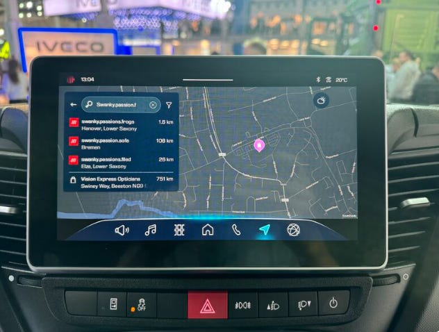
📌 what3words now live with Iveco Group:
🙂 Mappedin Offers Free Maps for Public Safety.

Webinar Promotion. Are you getting enough industry execs to sign up for your webinars? We’ve been promoting them for 15 years and know the ins and outs of webinar marketing. We will run a one-month campaign (with weekly reminders on our social media as the webinar gets closer). This includes ad placement in the newsletter, social media posts and a dedicated. email blast to our subscribers. We really hit it hard on social media in the final five days as people always register at the last minute. Email us at info@driverlessreport.com for more information, or click here to view our one-page media kit.
Connected and Autonomous Vehicles:
🚗 Waymo's Driverless Cars Are Coming to These Cities Next. “The Georgia and Texas Waymo experiences, set to launch early next year, will be a bit different than what California and Arizona riders encounter. Thanks to a partnership between former enemies Waymo and Uber, riders in Atlanta and Austin will be required to use the Uber app to hail a robocar.”
⚡ Verizon Business Inks 5G Connected-Vehicle Deal with Teledriving Car-Share Company Vay. “Verizon Business VZ 0.00%↑ and Vay Technology today announced an agreement bringing Verizon 5G connectivity to Vay’s fleet of teleoperated electric vehicles. The deal also includes custom data plans to help manage massive amounts of data generated by Vay vehicles’ sensors and cameras.”
🌍 Alibaba, Nvidia Collaborate on Advanced Autonomous-Driving Solution, Computing Services. “Alibaba Cloud has unveiled a large multimodal model solution for automotive applications that it co-developed with Nvidia NVDA 0.00%↑ and start-up Banma Network Technology.”
🚘 Ford's New Digital Experience Brings Android and Apple Into Balance. “Ford F 0.00%↑ has a good thing going with its next-gen infotainment system — whether you use CarPlay or not.”
Fleet: (Editor’s note: There was a lot of fleet telematics news this week!).
📌 RAC and Continental Automotive Launch Telematics Partnership.
🚛 Trimble Unveils Transporeon Visibility with TMS Integration. “Carriers and shippers in the road, ocean and air transportation sectors can access the locations of their shipments and vehicles in real time.”
📊 Urgently Completes Strategic Divestiture of The Floow. “Roadside assistance provider Urgently announced the strategic divestiture of its wholly owned subsidiary, The Floow, a UK-based telematics provider.”
🚍 Hitachi Unveils New Fleet Management System. “Hitachi Construction Machinery has developed a new fleet management system: Solution Linkage (SL) Connect. Providing access from phones, tablets or computers, SL Connect users can monitor machines on different worksites from any location.”
👉 Cummins, Bosch, and KPIT to Launch Open Telematics Portal.
🚚 Semtech and Traxmate Enable Precision IoT Asset Tracking.
✈ Targa Telematics Drives Ground Handling Work in Airport Services Association Tie-Up. “Targa Telematics has signed up as a member of the Airport Services Association (ASA), spurring its work on ground handling.”
🏅 INGEEK Recognized in 2024 Gartner Market Guide for Fleet Telematics.
Financial:
✔ Spanish IoT Startup Sateliot Raises $33 Million Series B Round.
✔ Iridium Board of Directors Approves Additional $500 Million Share Repurchase Program.
Location Industry Briefs
Send your news releases to kdennehy@driverlessreport.com. Go to www.locationbusinessnews.com for more news and an archive of stories.
Geotab Integrates Data from Volkswagen Group Fleets
Geotab has partnered with Volkswagen Group Info Services AG for telematics services. If Geotab’s fleet customers consent, built-in sensors will collect vehicle generated data from Volkswagen Group fleet vehicles, the company said. Upon request, this data is transferred to the Geotab platform via an application programming interface (API).

Fleet operators can optimize routes, increase fuel efficiency, identify electrification potential, encourage better safety, and reduce idling times, the company said. MyGeotab processes data into insights to provide fleet managers with a better understanding of fleet performance.
Contact: Geotab, www.geotab.com/uk.
Trimble Rolls Out Reality Capture Platform Service
Trimble TRMB 0.00%↑ has launched its Reality Capture platform service, designed to streamline data management, visualization and collaboration. The service, integrated as an extension inside Trimble Connect cloud software, is available via subscription.
It allows surveyors and reality capture professionals to share and collaborate, store and manage massive datasets securely and efficiently in the cloud, the company said. It allows streamline workflows for datasets large and small, whether captured via terrestrial 3D laser scanners, mobile mapping systems or UAV platforms, the company said.
Contact: Trimble, www.trimblegeospatial.com.
LexisNexis Risk Solutions Aligns with Radar
LexisNexis Risk Solutions RELX 0.00%↑ has partnered with Radar to integrate Radar’s geofencing, mapping and geo-compliance capabilities with data and technology from LexisNexis Risk Solutions. The companies plan to offer a solution for gaming and gambling operators to help ensure that devices used for online gambling in the United States comply with applicable state regulations, the company said. Currently, 38 US states plus the District of Columbia have legalized mobile gambling, the company said.
Contact: LexisNexis Risk Solutions, www.risk.nexislexis.com.
StarNav Makes Successful Demo at ION GNSS+
StarNav’s receiver showed the first live demonstration of cold start positioning and timing using Xona PULSAR signals at the recent ION GNSS+ conference. The receiver produced real time signal tracking and PNT by receiving signals produced by a Safran GSG-8 simulator.
StarNav’s receiver, which is now available for purchase, produces measurement observables, PNT data, an other metrics for LEO PNT adopters and researchers, the company said. StarNav and Safran have partnered to test each of their technologies, which are bringing PULSAR receiver and simulation capabilities to the industry, the company said.
Create a FREE ManyMe Account.
Digital Matter Rolls Out G150 Global
Building on G120's success, Digital Matter has rolled out the G150 Global. The module offers global connectivity, periodic tracking, continuous accelerometer sampling and an optional external cellular antenna for enhanced range.
The unit also offers an integrated Bluetooth gateway, versatile inputs/outputs, and compatibility with an Iridium Edge Module to enable effective driver management, safety, and vehicle monitoring, the company said.
Contact: Digital Matter, www.digitalmatter.com/devices/g150-global.
Garmin Named 2024 Manufacturer of the Year by NMEA
Garmin GRMN 0.00%↑ has been named Manufacturer of the Year in the large manufacturer category for the 10th consecutive year by members of National Marine Electronics Association at its recent annual conference
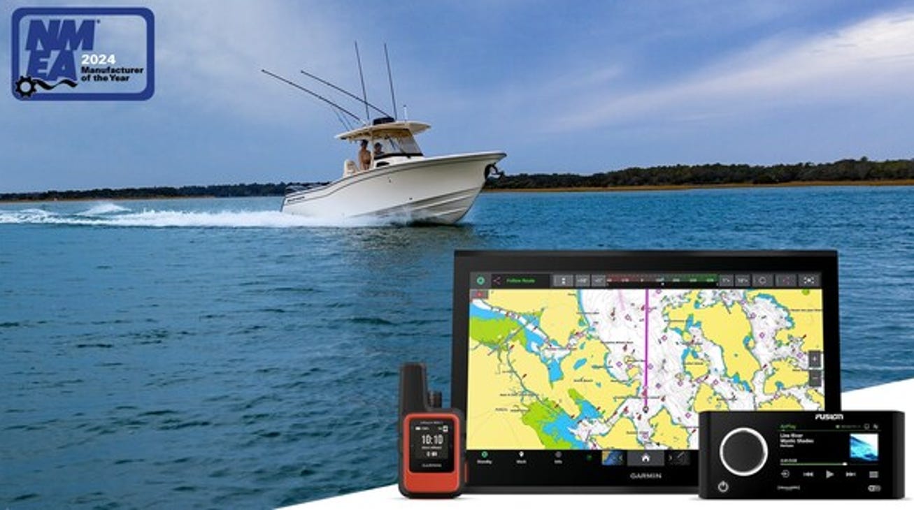
Garmin was also awarded six Product of Excellence awards in the multi-function display (MFD), autopilot, multimedia entertainment, automatic identification system (AIS), satellite communication antenna and marine apps categories.
Contact: Carly Hysell, Garmin, (913) 397-8200, media.relations@garmin.com.
People
The Institute of Navigation has awarded John Raquet with the Johannes Kepler Award at the ION GNSS+ 2024 Conference in Baltimore last week.
Raquet is credited for inventing the first network of differential receivers that performed carrier-phase differential GPS over a large area.
Pointr has named Evren Tan as vice president of development operations.
Silvana Capasso has been named director of worldwide FAE at Septentrio.
Daniel McElaney has been named solutions sales manager at Ford Pro.
beaconsmind Group has named Damian Sunil Rick as product manager/product owner and Harun Keser as director of business development.
Jobs
Senior Product Manager. Swift Navigation.
Partner Manager. LEVL Telematics.
Creative Director - Customer Experience. Harman.
Click HERE to Join our growing Location Business News LinkedIn Group!


