


Texas Gets $1.4 Billion Google Settlement Over Location Tracking Violations
Paid Subscribers also get access to SpaceX’s plan to use Starlink for GPS augmentation, Mexico’s lawsuit against Google and Woolpert makes big acquisition. Plus Jobs and People.

Keysight’s Spirent Acquisition Faces Delays
Keysight Technologies' KEYS 0.00%↑ acquisition of Spirent Communications is facing delays as it awaits regulatory approvals in the United States and China, the companies announced. The nearly $1.5 billion deal, which saw Keysight outbid Viavi Solutions VIAV 0.00%↑ for Spirent, was initially expected to close by the end of April but is now anticipated to be finalized before the end of July.
In a trading update, Spirent reported that its revenue and orders were "in line with our plan and in line with the same period last year." As part of the acquisition, Keysight has agreed to divest some of Spirent's assets, including its high-speed ethernet and network security business, which Viavi Solutions is set to acquire upon the deal's completion.

Meanwhile, Viavi Solutions is expanding its own location industry portfolio. As Location Business News reported in December 2024, the company announced its acquisition of Inertial Labs late last year for $150 million at closing and as much as $175 million of contingent considerationi. According to Viavi, Inertial Labs' offerings, which include Inertial Measurement Units (IMU) and Inertial Navigation Systems (INS), are "highly complementary" to Viavi’s existing PNT (Position, Navigation and Timing) and other aerospace and defense solutions.
For its part, Crawley, England-based Spirent said it won a lunar and space exploration contract during the quarter for its Positioning business.

Are you ready for your next Trade Show? JB Media is your one-stop shop for printing, promotional products and corporate wearables. Let us help you prepare for your next show! Visit our website, e-mail us at Service@JimBrownMedia.com or call us direct at (720) 588-0493.
FCC Advances Next-Gen 911 with Focus on Indoor Location
The Federal Communications Commission (FCC) is taking steps to improve the accuracy of location information for 911 calls, particularly those made from inside buildings, a move that will affect wireless carriers and create new opportunities for technology companies. The FCC's efforts, which were proposed last week and centered on Next Generation 911 (NG911), is a call for upgrading the nation's emergency call systems to use internet-based technology.
Comments are due on or before June 6, 2025, and reply comments are due on or before July 7, 2025, the agency said.

NG911 aims to replace the current analog-based systems, which can struggle to pinpoint the precise location of callers, especially in multi-story structures. According to the FCC, this upgrade is crucial for enabling faster and more effective responses to emergencies. The transition to NG911 involves a complex overhaul of the existing infrastructure, with the goal of providing more accurate and detailed information to 911 call centers.
The FCC is proposing rules to enhance location accuracy, interoperability, and resiliency, including augmenting GPS with alternative positioning, navigation, and timing technologies, according to an FCC report. This initiative is expected to drive innovation and create opportunities for companies specializing in indoor mapping, location services, and related technologies. Brian Fontes, the CEO of NENA, the National Emergency Number Association, told GovTech that there will be "a competition among them to meet the new standards."
For wireless carriers, these changes will require significant investment and upgrades to their networks. The FCC is pushing carriers to provide more precise address-level information, such as street addresses plus room or apartment numbers. This may involve deploying new technologies and improving data management systems. The rules could also lead to increased collaboration between carriers and public safety agencies, as well as technology vendors.
The push for more accurate indoor location data has significant implications for public safety. As the FCC states, "Better location information from the outset of a 911 call translates to time saved during a response, and that time saved translates to lives saved."
Snap Map Hits 400 Million Monthly Users
Snap Map, a feature within the Snapchat app that allows users to view locations and events, has reached more than 400 million monthly active users, parent company Snap SNAP 0.00%↑ announced last week.
Snap Map allows Snapchatters to connect with friends and explore their surroundings. The feature differentiates itself from traditional digital maps by emphasizing real-time connections to a user's physical world, according to the company.
Snapchat, launched in 2011, initially gained popularity for its disappearing photo and video messages, particularly among teenagers and young adults. According to Snap Inc.'s investor relations site, the company reported 800 million monthly active users across the entire Snapchat platform as of 2024.

The growth of Snap Map reflects Snapchat's efforts to expand its features and retain users. The company has increasingly focused on location-based services and partnerships to enhance user engagement and create opportunities for businesses, including "Promoted Places" on Snap Map.
Snap Map's user base indicates its importance within the Snapchat ecosystem, providing a platform for users to make plans, discover local businesses, and stay informed about nearby events.
However, Snap Map has also raised privacy concerns. The feature's ability to show a user's location in real-time has led to worries about potential stalking or unwanted attention, particularly for younger users. Users can control their visibility on the map, but the default setting and the app's design have led to scrutiny from privacy advocates.
Apple Maps to Launch Formula 1 Features
Apple AAPL 0.00%↑ said this week that it will bring an immersive Formula 1 experience to Apple Maps. This experience will give fans a detailed and interactive look at race venues starting with the Miami Grand Prix.
The new features include custom 3D landmarks, real-time navigation, curated Apple Music playlists, and exclusive Apple News coverage tied to the event.
As part of the launch, Apple Maps users in select U.S. cities will be able to explore the race environment before and during the Grand Prix. The feature builds on Apple’s recent partnership with Formula 1, the company said.

The initiative coincides with Apple’s broader content strategy, which includes the highly anticipated Formula 1 film starring Brad Pitt and produced by Apple Studios. Apple has been steadily integrating sports into its digital platforms, most notably with its partnership with Major League Soccer and its increasing investment in original sports-related content.
Apple said the Formula 1 Maps experience will be rolled out for future races, including the Austin and Las Vegas Grands Prix. The company has not confirmed whether similar features will be expanded internationally or made available for other sporting events.
Weekly Location Industry News
News tip? Send them to kdennehy@driverlessreport.com. Go to www.locationbusinessnews.com for more news. Location Business News is looking for your company’s news, products and use cases to feature in each issue.
Top News:
🔥 NextNav FCC Proposal Meets Flurry of Comments. NextNav NN 0.00%↑ asked the FCC on Wednesday to advance an NPRM analyzing its proposal for PNT in the lower 900 MHz band as an alternative to GPS. However, a plethora of companies are determined to persuade the FCC to stop the company’s filing.
“The record before the FCC clearly demonstrates that building a complement and backup to GPS is an urgent national security and public safety priority. NextNav offers a near-term, market-driven solution to meet this need,” said Mariam Sorond, NextNav CEO, in a statement. “While some opponents rely on unsupported rhetoric to preserve the status quo, the Commission should not be swayed by flawed technical analysis or entrenched resistance that would delay meaningful progress toward advancing a system of systems approach to PNT resiliency.”
Although the company has many industry detractors, AT&T’s T 0.00%↑ FCC comments seem pro-NextNav in their comments as they called for “market-based and "future-proof" solutions and specifically mention the company in the context of "market forces will still provide an economically viable complement or alternative PNT service."
🌑 GMV to Develop GPS for the Moon. “GMV is set to develop a lunar navigation system, aiming to provide GPS-style positioning for future missions to the moon. The company announced the project on May 9, 2025, with the goal of facilitating crucial tasks such as landings, takeoffs, and rover navigation. The system, known as Moonlight, will use a network of satellites in lunar orbit to deliver precise positioning data.”
🛰 GPS Needs To Toughen Up, Or Get Trampled Down. “Even with no ITAR restrictions, there are major challenges to widespread adoption of jam-resistant GPS CRPAs for civil aircraft. First, updated RTCA standards must be published. Next, avionics manufacturers need to develop the infrastructure and invest in tooling needed to make GPS CRPAs.”
🛳 Pole Star Confirms GPS Interference Caused MSC ANTONIA Grounding. “The incident occurs amid an alarming increase in GPS interference in the region. On May 9th, the day before the grounding, the UK Maritime Trade Operations (UKMTO) said it had received a number of corroborating reports from vessels experiencing GPS interference affecting navigation systems in the Red Sea, with disruptions lasting several hours.”
🚔 Council Weighs in on Seattle Police 'Pursuit Mitigation GPS Tracker Launchers.' “The Seattle City Council’s public safety committee is hearing details of the proposed addition of StarChase GPS “pursuit technology” to Seattle Police Department vehicles.”
⚡ New Stanford GNSS Interference Detection using ADS-B Site.
👌 Big Tech Enters the Map: What Google and NVIDIA Mean for Geospatial AI. “With both companies making strategic moves into geospatial AI, how will the geospatial industry adapt?”
✈ NATO Addresses Electromagnetic Interference Threats to Civil Aviation Safety – NATO News.

Expert nationwide installation services for fleet technologies.
Maps
See our story, for paid subscribers, below about the Mexican government lawsuit against Google GOOG 0.00%↑ for its Maps using “Gulf of America.”
📱 Bee Maps Adds Lyft as Customer. “Since 2019, [Lyft] LYFT 0.00%↑ have invested heavily in open and crowdsourced mapping, adopting OpenStreetMap (OSM) as its base map, contributing millions of edits, and harnessing its driver community to keep those maps current.”
🤞 Apple Maps Quietly Gets a Major Update As the DCE Rollout Continues. “Apple AAPL 0.00%↑ has seemingly accelerated the release pace for the detailed city experience in Apple Maps, bringing its new maps to users in Copenhagen.”
🤔 "Everybody Install Waze": City Tells People to Download the App to Eliminate Traffic Jams. “The City of Calgary has recently announced a partnership with Waze, promising to address traffic jams and introduce real-time measures as long as more residents install the app and report what they see on the road.”
🗺 Naver Partners with NGII to Build High-Precision Digital Maps. “Naver is teaming up with the National Geographic Information Institute (NGII) to develop high-precision digital maps.”
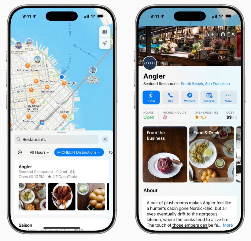
🙂 Apple Brings Insights, Ratings, and Reviews From Expert Sources to Apple Maps. “Users can now view and search for restaurants and hotels in the U.S. with distinctions from MICHELIN Guide; The Infatuation and Golf Digest coming soon.”
👍 A New Age of Mapmaking, Powered by AI. “This shift is enabling what we call live maps—constantly evolving representations of the world that reflect real-time changes. Whether there’s construction, a new traffic rule or a sudden road closure, live maps help ensure drivers and systems can react to changes as they happen.”
⏱ IFS Selects TomTom's Location Technology to Enhance Planning and Scheduling Solutions. “TomTom has been selected by IFS to enhance their Planning and Scheduling Optimization (PSO) platform, delivering precise route calculations and travel time estimations across asset- and service-intensive industries globally.”

👏 How to Use Apple Maps on the Web. “Apple’s mapping platform is no longer exclusively for Apple devices. A pared-down version runs in your browser; here’s how to use it.”
🥇 Joe McCallen, 63, has mapped 100000 miles of road for Google's immersive map. He has no plans to stop. New York Times (subscription required).

Become a Paid Subscriber to Location Business News! Only $8 per month!
What Paid Subscribers get:
Full access to more than 200 Archived issues (stories, contacts, analysis).
A new subscriber-only Chat Board.
Access to Analysis and In-Depth Articles, plus People and Jobs.
Free entry to LBN-branded webinars and receptions at major trade shows (in development).
Steep Advertising Discounts for paid subscribers and Founding Members.
We average 30,000 views on our websites each month. Advertising starts at only $150 per issue. Please contact us at info@driverlessreport.com for more information…or go to our updated Advertising Page.
Connected and Autonomous Vehicles:
😮 Waymo Recalls 1,200 Self-Driving Vehicles in US After Minor Collisions. “Waymo is recalling more than 1,200 self-driving vehicles to update software and address risks of collisions with chains, gates and other roadway barriers after U.S. auto safety investigators opened a probe last year. The recall affects 1,212 Waymo vehicles operating on the company's fifth-generation automated driving system software, the company said.”

😒 Ford Cutting Hundreds of Connected-Vehicle Software Jobs. “Ford Motor Co. F 0.00%↑ is cutting about 350 connected-vehicle software jobs in the U.S. and Canada as part of an ongoing effort to improve efficiency, according to a person with knowledge of the moves. Affected workers were notified May 13. The employees work on projects that include the newly launched Ford and Lincoln Digital Experience.”
😦 Billionaire Founder of Luminar Replaced as CEO Following Ethics Inquiry. “Austin Russell, who became a billionaire after his lidar startup Luminar LAZR 0.00%↑ went public, appears to be out as CEO, according to the company’s board.”
🚘 Waymo to Bring Self-Driving Cars to Boston Area, Including Major Highways. “The vehicles are due to arrive in Massachusetts later this month and the company said they'll be seen in areas including Mission Hill, East Boston, Cambridge, Somerville and South Boston. Motorists can also expect to see the vehicles on the Mass Pike and Interstate 93, Waymo said in a statement.” Editor’s Note: This will be a good proving ground for robotaxis with the plethora of crazy masshole drivers and gridlocked I-93 traffic.
🤷♂️ Volvo EX90’s Lidar Sensor Will Fry Your Phone’s Camera. “Laser beams don't play nice with camera image sensors, and Volvo recommends avoiding close-up photography or using a protective filter if you must snap a pic.”
🚛 Aurora Innovation, Bot Auto Operating Self-Driving Freight Trucks in Houston. “Both companies say they are operating with Level 4 automation.”
🏛 Californian Autonomous Vehicles Get a Revised Regulatory Load if New DMV Law Passes. “On April 25, 2025, the California DMV released a notice of proposed regulations focused on changes to the testing and deployment of light-duty and heavy-duty commercial autonomous vehicles. California previously released draft regulations and asked for public comment, the last round ending Aug. 30, 2024.”
🚗 HARMAN Becomes One of the First to Open-Source Complete Connected Services Platform with Eclipse Foundation. “HARMAN has become one of the first to open-source a full connected services platform. The platform, now available through the Eclipse Connected Services Platform (ECSP) project, is now publicly available. The platform is designed to support connected car deployments of up to 100K vehicles.”
😟 Tesla's Robotaxi Plans Have the Attention of Federal Investigators. “The National Highway Traffic Safety Administration’s Office of Defects Investigation wants the additional information about Full Self-Driving (Supervised) — or “FSD” — in order to “understand how Tesla TSLA 0.00%↑ plans to evaluate its vehicles and driving automation technologies for use on public roads,” according to the letter published Monday and first reported by Reuters.” Editor’s Note: Well, which is it? Elon Musk’s DOGE fires all of the NHTSA staff investigating him…and now they are investigating him?
Fleet Telematics:
💰 LB Technology Awarded 5-Year Statewide GPS Telematics Contract by the State of Arizona. “The renewed agreement includes the deployment of LB Technology's newly released FleetTrack 2.0.” Financial details were not disclosed.
👉 Samsara Launches Recognition for Drivers to Help Fleets. “Samsara IOT 0.00%↑ has announced the global launch of Recognition, a new feature designed to help fleets celebrate safe driving behavior and strengthen driver engagement—without adding administrative overhead.”
🚍 Driver-Centric Telematics Services Could be Secret Weapon in Fight Against Driver Churn. “While telematics adoption is on the rise, not all commercial vehicle and fleet decision-makers are fully convinced of telematics’ value. Only about one-quarter of current shoppers and half of current users say telematics are either critical to operating their business or fully meet their needs,” said Dania Rich-Spencer, a vice president in Escalent’s Automotive & Mobility division.
🚚 Cable Insurance Selects TruckerCloud as Telematics Partner.
Financial:
😮 Luminar Stock Plunges After Founder Exit and Wider-Than-Expected Loss.
✔ NextNav Reports First Quarter 2025 Results and Operational Highlights.
✔ Globalstar Announces First Quarter 2025 Financial Results.
✔ Life360 Reports Record Q1 2025 Results
✔ MapmyIndia's Q4 Net Profit Rises 28 Percent; Shares Jump Nearly 9 Percent.
✔ Iridium Q1 Earnings Call: Revenue Beats, Tariff Uncertainty and IoT Momentum Shape Outlook.
✔ Phunware Reports First Quarter 2025 Financial Results.
✔ Innoviz Technologies Ltd. 2025 Q1 - Results - Earnings Call Presentation.
✔ Pony AI Inc. Announces Voluntary Extended Lock-Ups by Founders.
✔ SuperCom Reports Record Net Income of $4.2 Million and EPS of $1.2 for First Quarter 2025.

The D-Day Visitor's Handbook: Your Guide to the Normandy Battlefields and WWII Paris by Kevin Dennehy and Steve Powers. The guidebook uses location technology from what3words to locate monuments, museums and other attractions. Get your guidebook today.
Weekly Product News
Send your news releases to kdennehy@driverlessreport.com. Go to www.locationbusinessnews.com for more news and an archive of stories.
Thalwil, Switzerland-based u-blox has launched PointPerfect Global, a new GNSS correction service designed to deliver high-precision positioning worldwide. The company said it will cater to applications such as precision agriculture, UAV-based mapping, and autonomous robotics.

PointPerfect Global aims to provide sub-decimeter positioning accuracy, even in remote locations, using both internet and L-band satellite broadcast, the company said. The company said the service is optimized for its ZED-X20P GNSS receiver, which will be the first to support PointPerfect Global with integrated L-band support. The company plans to begin early access to PointPerfect Global in late 2025, with general availability expected in the first half of 2026.
Contact: Sven Etzold, u-blox, 41 76 561 0066, sven.etzold@u-blox.com.
Winnebago, KORE Launch Connected RV Platform
KORE KORE 0.00%↑, Robo ROBO 0.00%↑, Ericsson ERIC 0.00%↑, and Winnebago WGO 0.00%↑ have collaborated to launch Winnebago Connect, a platform that integrates IoT technology to enhance the recreational vehicle (RV) experience. KORE's IoT solutions provide global connectivity, Robo delivers the software for the user interface, and Ericsson supplies network solutions.

The platform offers features such as smart notifications, GPS tracking, remote climate control, and smart energy management. Ron Totton, KORE president and CEO, said the platform empowers RV owners to travel with confidence and convenience.
Contact: Stephen Rana, Kore Wireless, sbell@korewireless.com, www.korewireless.com.
Trimble Debuts Forestry One Platform to Modernize Timber Operations
Trimble TRMB 0.00%↑ has launched Forestry One, a cloud-based software platform designed to connect and streamline workflows across the forestry supply chain. The platform aims to enhance visibility, decision-making and productivity from planning to harvesting. Forestry One consolidates multiple tools into a single solution, offering real-time collaboration for landowners, managers and contractors, the company said. Forestry One allows end-to-end timber tracking that tracks timber movements from the forest to the mill, the company said.
Contact: Trimble, www.trimble.com.
STMicroelectronics Launches Miniature AI Sensor for Smarter Wearables and IoT Devices
STMicroelectronics STM 0.00%↑ has unveiled a compact, AI-enabled sensor that integrates activity tracking and high-impact event detection for personal electronics and IoT applications. The new LIS2DUX12 and LIS2DUXS12 sensors combine a three-axis accelerometer with a finite state machine and machine learning core to deliver efficient on-device intelligence, the company said.

Designed for ultra-low power consumption, the sensors are optimized for use in fitness trackers, smart wearables, and wireless sensor nodes. ST says the sensors are currently in production and available for order.
Contact: Alexis Breton, STMicroelectronics, 33 659167908, alexis.breton@st.com, www.st.com.

Create a FREE ManyMe Account.
TwoNav Launches Outdoor Navigation App
TwoNav has launched its TwoNav 6 outdoor navigation app. TwoNav 6 features an editor that allows users to create routes, itineraries or modify the layout of an existing route, the company said.

The TwoNav Premium and Pro subscriptions include OpenStreetMap routable map with worldwide coverage. Other map features include urban roads, mountain trails, rivers, peaks, and key points of interest for each country, the company said.
Contact: Santiago Twose, TwoNav, stwose@twonav.com, www.twonav.com.
SeRo Systems Launches Real-Time Display to Detect GPS Jamming and Spoofing
SeRo Systems has introduced a new real-time GNSS Radio Frequency Interference (RFI) Situation Display to monitor and detect GPS jamming and spoofing threats. The display provides live analysis of RFI events, offering users immediate visibility into signal disruptions across the globe, the company said.

It supports multiple use cases, including aviation, defense, and critical infrastructure protection. The technology aims to enhance situational awareness and enable faster responses to interference incidents, the company said.
Contact: SeRo Systems, www.sero-systems.de.
Bluedot Enables Charging Experience for Rivian’s Service Fleet
Bluedot announced it is now powering the charging experience for Rivian’s service fleet across the United States. The integration provides Rivian with a streamlined solution for locating, charging, and managing electric vehicle charging sessions. Bluedot's platform offers features such as real-time charger availability, automated payments, and energy cost tracking. The collaboration aims to enhance operational efficiency and reduce downtime for Rivian’s service vehicles.
Contact: Bluedot, fleet@thebluedot.co, www.bluedot.co.
Teledyne to Showcase Underwater Surveillance Tech
Teledyne Geospatial is participating in the SeaSEC Challenge Weeks in the Netherlands, showcasing its technology for securing undersea infrastructure. The event, running from May 12-23, demonstrates expertise in underwater surveillance.

Teledyne Geospatial, along with Teledyne Marine and Teledyne FLIR, will demonstrate a rapid method for underwater surveillance. This method uses an airplane equipped with airborne lidar and CARIS software, providing high-speed, high-resolution underwater surveillance that is 45 times faster than traditional methods.
Contact: Jennifer Parham, Teledyne Geospatial, jennifer.parham@teledyne.com.

Click HERE to Join our growing Location Business News LinkedIn Group!
Texas Gets $1.4 Billion Google Settlement Over Location Tracking Violations
Texas Attorney General Ken Paxton has announced a nearly $1.4 billion settlement from Google GOOG 0.00%↑, which dwarfs others states’ settlements surrounding the tech giant’s alleged deceptive location tracking practices.
Paid Subscribers get the rest of the story below, plus SpaceX’s call to use Starlink to augment GPS, Mexico’s lawsuit against Google for using the ‘Gulf of America’ moniker on Google Maps and Woolpert makes big acquisition. Plus Jobs and People.
Keep reading with a 7-day free trial
Subscribe to Location Business News to keep reading this post and get 7 days of free access to the full post archives.