


Trimble Completes Telematics Business Sale to Platform Science
Deal gives Trimble seat at board of directors with other transportation heavy weights...paid subscriber analysis below, plus Is GPS OCX really ready to go?

EasyPark Acquires Connected Car Parking Player Parkopedia
EasyPark Group has finalized the acquisition of United Kingdom-based Parkopedia. While financial details were not disclosed, the deal brings together two tech parking companies who have collaborated for the past 10 years.
Each of the companies brings its own parking expertise. In Parkopedia’s case, it offers advanced in-car data and payment technology for parking, EV charging, fueling and tolling. For EasyPark Group’s part, it also provides digital payments across parking systems, digital platforms and in-car solutions, the company said.
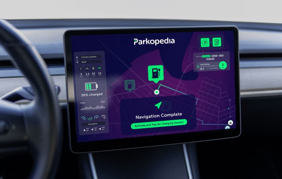
“Parkopedia’s in-car data integration and payment technology, coupled with our digital parking solutions and on-street parking equipment, allows us to address the entire driver experience,” said Cameron Clayton, EasyPark Group CEO, in a statement.
Parkopedia’s expertise in indoor parking garage mapping is also a solid reason to acquire the up and coming parking vendor. The companies also say the data insights acquired by the companies also shape mobility and transportation policies in urban areas.
In other company news, Parkopedia and AWT Bavaria Ukraine, in conjunction with BMW AG, have completed the integration of 4,272 Ukrainian charge points into selected BMW models and the MyBMW app. The new partnership allows AWT Bavaria Ukraine and Parkopedia to ensure transition to EVs in this emerging market, the company said.
Geo Week Features Most GNSS, Lidar Companies
DENVER—The Geo Week conference here featured most GNSS, lidar and other location companies who are trying to grab a larger share of the uncrewed systems market, particularly for survey and mapping applications. Organizers say the conference, once held in a nearby hotel and then seen as a drone tech show, has grown to 3,000 attendees and a sold-out exhibit hall at the Colorado Convention Center.

One company, California-based Looq AI, offered its Q camera that integrates Septentrio’s mosaic-X5 GNSS module receiver to offer centimeter-grade PPK accuracy for survey-grade 3D modeling. The handheld Q creates a digital twin of to modernize asset management, infrastructure maintenance, surveying and other applications, said CEO and co-founder Dominique Meyer.

“With 3D modeling, we are serving companies quickly with analysis, whether that’s creating bathymetric surveys or overhead. Accuracy is paramount, so we integrated GNSS modules, out of the box, for survey,” he said. “I see this market loaded with lidar systems, but we have to think out further, how do we save companies more money and time?”
The mosaic receiver is integrated with INS and four cameras, which captures data needed for a georeferenced 3D model of the environment. Looq AI believes the end result is 100 times the data rates and spatial sampling compared to a laser system.

San Francisco-based Point One Navigation, which exhibited at Geo Week, said that in mid-2024 they finished a virtual network of more than 950 base stations to offer true RTK. “We now have 70 percent of the U.S. land mass coverage. We are working on L-band in beta with a few customers,” said Chris Dima, Point One’s director of growth. “We have been growing in the utility space—and we’re shipping a lot of base stations. One service company has switched from GPS to RTK in one fell swoop for more than 500 licenses.”
In Geo Week product rollouts:
Xenomatix’ new XenoBike, a four-wheel electric bike, is equipped with sensors for pavement inspection. It features lidar, cameras, and GNSS.

XenoBike Leica Geosystems, part of Hexagon, announced an airborne hydrographic mapping unit, Leica CoastalMapper. Designed for shallow to deep-water surveys, the lidar sensor increases collection efficiency by 250 percent compared to previous generations, the company said. CoastalMapper integrates a bathymetric lidar module with a Leica TerrainMapper-3 topographic lidar and imaging into a lightweight sensor head, the company said.


Topcon Positioning Systems partnered with Pix4D to combine geopositioning and photogrammetry solutions. Topcon will become an authorized distributor of Pix4D’s photogrammetry software portfolio. This allows greater customer access to positioning and 3D mapping technologies, the company said.
CompassData celebrated its 30th anniversary at Geo Week. The company highlight its ISO and FAA and made three presentations at the conference. CompassData’s main offering is its archive of 80,000 photo-identifiable GCPs collected in more than 100 countries.
Editor’s note: Full Geo Week coverage will be in our next Location Business News issue.
Deutsche Telekom and Swift Navigation Expand Skylark PPS into Eastern Europe
Deutsche Telekom and San Francisco-based Swift Navigation have expanded Swift’s Skylark Precise Positioning Service into Eastern Europe, the companies said. Skylark is now available in Bulgaria, Croatia, Greece, Poland, Romania, Slovakia, and Slovenia.
In addition, in close cooperation with Deutsche Funkturm, a leading tower company in Germany, Swift and Deutsche Telekom have co-designed, deployed, and now jointly operate the highly reliable network of Continuously Operating Reference Stations (CORS) that deliver industry-leading precise positioning services across Europe, the company said.

Swift and Deutsche Telekom recently conducted a four-day, 2,000-kilometer drive test from Hanover, Germany, to Barcelona, Spain. The companies say the trip covered five countries. Even though the terrain included dense urban areas, canyons, and tunnels like Mont-Blanc and Gotthard, the companies say Skylark achieved lane-level positioning accuracy for 97 percent of the drive.
TomTom’s Position on Gulf of America…To Not Ruffle Anyone’s Feathers?
At our deadline, TomTom [Tom2] reached out to us to clarify the company’s position on the recent President Donald Trump/Geographic Names Information System (GNIS) decision to change the name of the Gulf of Mexico to the Gulf of America.
“While [GNIS], the authoritative standard database for geographic titles in the US, has officially changed the name—global standardization remains uncertain,” the company said. “The International Hydrographic Organization (IHO), the global authority on water body names, has not yet recognized a change from "Gulf of Mexico" internationally, raising questions about how digital maps handle conflicting geographic data,” the company said.

As a result, TomTom will be changing the Gulf of Mexico to the Gulf of America for U.S. users, while keeping the default map’s name as the Gulf of Mexico. Users will be able to change the view based on their preferences, the company said.
"At TomTom, we prioritize real-time, authoritative data to ensure our maps reflect the most accurate, up-to-date information. Geographic names, especially those tied to global standards, should be informed by trusted sources and international consensus to maintain consistency across borders,” said TomTom’s Brandy Boyle, maps manager. “We monitor authoritative sources such as the [GNIS] and work closely with local and international bodies to validate any changes. In this view, the U.S. continental shelf area bounded by Texas, Louisiana, Mississippi, Alabama, and Florida—extending to the seaward boundary with Mexico and Cuba—will be labeled as the 'Gulf of America,' while the southern part of the gulf will continue to display Gulf of Mexico.”
Boyle said that users will find both names of the gulf when referencing the same location. “TomTom maps users will be able to choose between the US-view or default maps based on their situation. Ensuring that our global maps remain precise, reliable, and free from unnecessary confusion is essential to serving citizens, government authorities, and businesses worldwide,” she said.
Weekly Location Industry News
News tip? Send them to kdennehy@driverlessreport.com. Go to www.locationbusinessnews.com for more news. Location Business News is looking for your company’s news, products and use cases to feature in each issue.
Top News:
👍 Synaptics Expands Wireless Portfolio with Broadcom Deal, Targeting IoT & Android Ecosystems. “Synaptics announced it has accelerated its edge AI strategy by signing a definitive licensing agreement with Broadcom AVGO 0.00%↑ that includes Wi-Fi 8, ultra-wideband (UWB), Wi-Fi 7, advanced Bluetooth, and next-generation GPS/GNSS products and technology for IoT and Android™ ecosystem. Expected to add more than $40 million in annualized sales”
👉 GPS Civil Signals Are Vital for America's National Security. “It may seem counterintuitive, but initiatives that divert funds to build “military only” GPS satellites operating in medium Earth orbit that focus solely on executing kinetic missions create challenges for our national security.”
🛰 Galileo Ground Stations Undergo Systemwide Migration. “ESA has commenced the large-scale migration of Galileo's Control Centres. This marks the start of a modernization effort aimed at upgrading Galileo's Ground Segment. ESA has spearheaded these upgrades with five European companies: Thales Alenia Space, GMV, Telespazio Belgium, Thales SIX, and Indra.
😐 Pentagon Acquisition Office Orders Review of Space Development Agency. “The review, according to the memo, is meant to ensure that SDA is on track to deliver that constellation, known as the Proliferated Warfighter Space Architecture, as well as the ground support required to operate fleets of missile tracking, communication and navigation satellites.”
💲 Synaptics Targets $40 Million Annualized Sales from Broadcom Acquisition with Expanded IoT Portfolio. “Synaptics SYNA 0.00%↑ announced a $198 million all-cash acquisition from Broadcom AVGO 0.00%↑ projected to generate over $40 million in annualized sales. [T]his transaction strengthens their Edge AI strategy and broadens their wireless connectivity portfolio, including WiFi 7/8 combo devices, UWB intellectual property, and next-generation GPS/GNSS products.”
👌 Myriota Expands IoT Constellation with Four New Satellites. “The Myriota Network supports industries like logistics, utilities, and agriculture by enabling global data monitoring and collection. It supports use cases like tracking, locating, and monitoring assets.”
🏛 Spire Global Sues Kpler to Complete Maritime Business Sale. “Spire Global SR 0.00%↑ has launched legal action to force Belgian analytics provider Kpler to complete its acquisition of the small satellite operator’s commercial ship-tracking business.”
⚡ IAI Successfully Integrates its ADA GNSS Anti-Jamming System with the M-Code GPS Receiver. “The ADA system, designed to protect GPS signals from RF interference, has successfully integrated with the M-Code GPS receiver, providing a powerful combination for enhanced GPS immunity.”
🤔 Gyroscope-on-a-Chip Targets GPS’s Dominance. “This year, two companies—Santa Clara, Calif.-based Anello Photonics and Montreal-based One Silicon Chip Photonics—have introduced new gyroscope-on-a-chip navigation systems, allowing for precise heading and distance tracking without satellite signals.”
🙁 Why GPS Is Getting Worse — And May Force Us to Revert to Old-School Maps.
🌎 NASA Study Finds California Coastal City Sliding into Pacific at 4 Inches per Week. “The Jet Propulsion Laboratory in Southern California measured the movement of the slow-moving landslides on the Palos Verdes Peninsula, using an airborne radar to collect data, they announced in a press release last week.”
🤷♂️ Qualcomm Says Arm Is No Longer Threatening to Take Its Chip Architecture Away. “Arm recently notified us that it was withdrawing its Oct. 22nd, 2024, notice of breach and indicated that it has no current plan to terminate the Qualcomm Architecture License Agreement,” Qualcomm CEO Cristiano Amon said during the company’s Q1 2025 earnings call.

Expert nationwide installation services for fleet technologies.
Maps:
📌 Here's How All Online Maps Are Handling the ‘Gulf of Mexico’ Name Change. Apple Maps, Google Maps (but with Gulf of America in parenthesis), Bing Maps have changed the Gulf of Mexico to Gulf of America. Baidu Maps, HERE WeGo, Mapbox, MapQuest, MapXplorer, OpenStreetMap, TomTom and Yandex have not…yet.
🌎 Apple Maps follows Donald Trump's Order, Renames 'Gulf of Mexico' to 'Gulf of America.' “According to reports, this change was implemented on Tuesday after an official order by President Donald Trump was confirmed by the U.S. Geographic Names Information System (GNIS).
📱 Google Maps Turns 20 – Here Are Its Most Popular Locations from the Past Two Decades, Plus Google's Favorite Hidden Tricks. “Happy birthday, Google Maps: the venerable app has turned 20, and to celebrate, Google GOOG 0.00%↑ has listed some of the most popular places on its maps, as well as sharing a bunch of Google Maps tips and tricks that you might not have come across before.”
📌 Google Maps 'Almost Destroyed' Google When It Went Live 20 Years Ago. “After presenting a dynamic map — now compatible with the web — Where 2 Technologies was acquired by Google for an undisclosed sum in October 2004. At the same time, Google also scooped up the satellite imagery service Keyhole, a critical component for developing Google Maps, since it opened access to scores of satellite images.”
🥇 Google Maps Is the World's Number 1 Navigation App, and These Numbers Prove It. “We've known for a while that Google Maps was the world's number one navigation app, ahead of rivals like Apple Maps, Waze, TomTom, and HERE, but the latest data shared by Google provides us with a clear picture of how people use navigation. Google Maps turned 20, so Google used this opportunity to reveal that in 2024 alone, the application offered 1 trillion kilometers of directions.”
😧 Android Auto Temporarily Lost TomTom Go Navigation App, Fix Now Available. “Complaints of the app not showing on Android Auto at all surfaced via the app’s Play Store reviews recently, where TomTom Go confirmed it is aware of the issue and working on a fix. Some users note that the app requests location permissions even through they’ve already been granted, while others say TomTom Go simply doesn’t appear on Android Auto.”

🤞 Google Maps Rival Releases a Feature That Makes Sense in Every Navigation App. “HERE WeGo has long been a powerful alternative, and every update released by the parent company brings it even closer to Google Maps in terms of functionality. The latest update bumps the app to version 4.15, and the highlight is the integration of vignettes and information when your route requires them.”
👌 Google Makes the Google Maps Interface Cleaner With a 2023 Idea. “The search company eventually embraced a more consistent approach, turning to round icons that included the original icons. Now, Google is rolling out another idea. Tested in 2023, this idea turns the saved places and favorite locations into small dots.”
📲 Waze Gets a New Navigation Voice and Vehicle Icon, Thanks to Paddington. “The latest update provides users with a new navigation voice, a new mood, and a new vehicle icon thanks to a pack released to celebrate the debut of Paddington in Peru in theaters worldwide.”

Become a Paid Subscriber to Location Business News! Only $8 per month!
What Paid Subscribers get:
Full access to more than 200 Archived issues (stories, contacts, analysis).
A new subscriber-only Chat Board.
Access to Analysis and In-Depth Articles, plus People and Jobs.
Free entry to LBN-branded webinars and receptions at major trade shows (in development).
Steep Advertising Discounts for paid subscribers and Founding Members.
We average 30,000 views on our websites each month. Advertising starts at only $150 per issue. Please contact us at info@driverlessreport.com for more information…or go to our updated Advertising Page.
Connected and Autonomous Vehicles:
😮 Lyft to Go Driverless in 2026 as Company Plans to Roll out Autonomous Car. “In a social media post, the rideshare company’s CEO David Risher said the driver-less vehicles could debut in Dallas by 2026. The company joined forces with Marubeni, a Japanese company that will own the fleet of cars that feature Mobileye Drive.”
🚗 Tesla Robotaxis by June? Musk Turns to Texas for Hands-off Regulation. “Elon Musk told investors in late January that Tesla TSLA 0.00%↑ would roll out “autonomous ride-hailing for money” by June in Austin, Texas — a state where the company faces almost no regulation.”
😒 Cash Cow to Money Pit: Why GM Decided to Let Cruise Go.
😕 Zoox Robotaxi Hands On: Safe but Lagging. “The toaster-shaped vehicle made safe if conservative decisions and offered a relatively comfortable ride through Las Vegas.”
🤔 Are Waymo’s Accomplishments & Methods Being Overlooked? “It seems the detail level Waymo uses is highly overstated. The size the map required at the resolution claimed by people to cover the 315 square miles in Phoenix that Waymo covers doesn’t math out.”
🚍 Autonomous Volvo Trucks Will Use This Firm’s Tech. “Autonomous tech developer Waabi reveals new partnership with Volvo Autonomous Solutions, with the company's AI tech slated to be used in the development of production SAE Level 4 trucks in the United States.”

🚘 May Mobility Offers Driverless Rides in Peachtree Corners, Georgia.
🎭 Waymo to Test Driverless Vehicles in New Orleans During Mardi Gras. “Waymo, the self-driving car division of Alphabet Inc., will launch a pilot program in New Orleans during Mardi Gras starting on Feb. 17 running for approximately three weeks. The goal of the pilot is to train Waymo’s driverless system to handle difficult road conditions and the timing of the trial to coincide with Mardi Gras is deliberate. New Orleans is already challenging, but Mardi Gras will set the bar even higher.”
👏 This New LiDAR Technology Can Recognize Your Face from a Full Kilometer Away. “This breakthrough was only possible due to an ultra-sensitive sensor called the superconducting nanowire single-photon detector that was co-developed by NASA and MIT.
👍 Motive Introduces AI Capabilities to Improve Driver Safety in Mexico
🙂 Hesai and BYD Partnership: 10+ Lidar-Equipped Models to Enter Mass Production in 2025.
Drones:
🛩 L3harris Unveils Amorphous Autonomy Software to Manage Drone Swarms. “L3Harris LHX 0.00%↑ on Monday unveiled a software platform, Amorphous, for controlling large swarms of uncrewed systems across multiple domains, allowing aerial drones, ships and other platforms to operate together seamlessly.”
😉 Ukrainian Drones to Evade Russian Jamming with New GPS Alternative. “Sine.Engineering built the system to counter Russia’s electronic warfare, which has wreaked havoc on GPS signals.”
Fleet Telematics:
💲 Massachusetts’ Office of Vehicle Management Chooses RTA for Fleet Management Information System Upgrade. “RTA has announced ‘a significant customer win’ with the Commonwealth of Massachusetts Office of Vehicle Management (OVM) under the state contract VEH118.”
👍 Mapon Acquires Swedish Fleet Management Company Interkom AB. “Draugiem Group company Mapon expands its presence in the Nordic region by acquiring 100 percent of the shares in Interkom AB, a fleet management provider based in Lund, Sweden. Mapon and Interkom AB offer fleet management and GPS tracking solutions
🌏 Global Telesat Awarded Satellite-Based Asset Tracking Services Contract. “Under the new contract, the second awarded to GTC by [an unnamed customer], it will provide Iridium Edge Solar satellite asset trackers and recurring airtime services contracts to monitor and track assets such as vehicles, heavy machinery and shipping containers.
📝Azuga Unveils Next-Generation Equipment Tracking Solution. “A centralized live map tracks vehicles, heavy assets, and equipment in real time.”
🚐 Freight Technologies Announces Commercial Launch of Fleet Rocket. “Freight Technologies FRGT 0.00%↑ has launched Fleet Rocket, a Transportation Management System (TMS) for brokers, shippers, and other logistics operators.”
🚛 Tracker Systems Launches GPS Tracking Solutions for Enhanced Fleet Management. “Tracker Systems, launched GPS tracking product that includes real-time tracking capabilities, comprehensive reporting tools, and user-friendly interfaces.
🚚 Nexar Announces Open Dataset and Nexar Dashcam Crash Prediction Challenge.
👌 RouteMate to Showcase Advanced Fleet Management Solutions at the Florida Trucking Show 2025.
Financial:
💲 US Auto Insurer HDVI Secures $40M to Enhance Telematics Offering. “This growth capital, which takes HDVI’s total capital raised to more than $87 million, will be used to enhance the company’s telematics-driven offerings.”
📊 QCOM Earnings: Qualcomm Falls Despite Solid Q1 Results and Guidance.
📈 TomTom’s CEO and CMO Purchase Shares. “TomTom [TOM2] announced that co-founders Harold Goddijn (CEO) and Corinne Vigreux (CMO) will be purchasing shares in the company. With this investment of up to €10 million, they reaffirm their confidence in TomTom's long-term vision, strategic direction, and people.”

The D-Day Visitor's Handbook: Your Guide to the Normandy Battlefields and WWII Paris by Kevin Dennehy and Steve Powers. The guidebook uses location technology from what3words to locate monuments, museums and other attractions. Get your guidebook today.
Weekly Product News
Send your news releases to kdennehy@driverlessreport.com. Go to www.locationbusinessnews.com for more news and an archive of stories.
HERE Technologies Rolls Out HERE WeGo Pro Truck Nav App
HERE Technologies has introduced HERE WeGo Pro, launched at the Manifest Supply Chain and Logistics Summit, to enable customizable mapping truck navigation for commercial fleet operators. HERE WeGo Pro offers optimized, multi-stop routing with road restrictions and real-time traffic conditions, the company said.

The company says the app is tailored for courier, express, and parcel (CEP) services; third-party logistics (3PL); operators of mid-size commercial vehicle fleets; and construction and heavy equipment logistics.
Contact: Jordan Stark, HERE Technologies, (312) 316-4537, jordan.stark@here.com, www.here.com.
VIAVI Launches Grandmaster Clock With 25G Precision Time Protocol
VIAVI Solutions VIAV 0.00%↑ has launched EdgeGM 7000, an Edge Grandmaster Clock that is part of the company’s SecurePNT portfolio. EdgeGM 7000 offers up to 25G Precision Time Protocol (PTP) and multi-orbit SecureTime altGNSS for PNT services.

The unit, which will be displayed at MWC Barcelona, is tailored for 5G/6G telecommunications, AI hyperscale data centers, defense, public safety, transportation, aviation, energy and finance, the company said. EdgeGM exceeds Level 4 PNT resiliency as specified in the IEEE P1252 standard, the company said.
Contact: Emma Jenkins, for VIAVI, (415) 800-4529, emma@grandbridges.com.
u-blox Updates Module for Rail Applications
Thalwil, Switzerland-based u-blox has updated its ZED-F9R for the rail applications.
The ZED-F9R-04B module, with an integrated IMU, features sensor fusion implementation.

The module delivers precise positioning and attitude data, surpassing GNSS-only solutions even in environments where satellite visibility is compromised, the company said. ZED-F9R-04B has been engineered to meet the unique challenges of rail navigation, the company said.
Contact: Sven Etzold, u-blox, 41 76 561 0066, sven.etzold@u-blox.com, www.u-blox.com.

Create a FREE ManyMe Account.
Topcon Agriculture Partners with Bonsai Robotics
Topcon Agriculture has partnered with Bonsai Robotics to advance agricultural automation for permanent crops. The collaboration will leverage Bonsai Robotics’ expertise in vision-based autonomous driving solutions and Topcon Agriculture’s capabilities with sensors, connectivity, and smart implements.

The collaboration combines the strengths of Bonsai Robotics’ vision-based, autonomous navigation systems with Topcon Agriculture’s advanced autosteering, telematics and smart implement integration.
Contact: Staci Fitzgerald, (925) 245-8610, Topcon Positioning Systems
corpcomm@topcon.com.
Thermo King Launches TracKing Smart Trailer Telematics
Thermo King has launched its TracKing Smart Trailer telematics for monitoring trailer health and cargo operations. The company says this platform complements the business's existing TracKing Pro telematics trailer, cargo and reefer tracking and monitoring.

The TracKing Smart Trailer telematics system features sensors, integrated video cameras and advanced analytics, the company said. The unit offers GPS tracking and provides route history and live trip monitoring, the company said.
Contact: Trane Technologies, info@3blmedia.com, www.3blmedia.com/profiles/trane-technologies.
Penguin Location Services Expands Healthcare Presence
Penguin Location Services is offering AI-driven navigation and real-time location solutions for intelligence in healthcare. The company said that its flagship products PenTrack, PenSafe, and PenNav provide real-time asset tracking for patient monitoring. Penguin Location Services offers sub-meter accuracy using Bluetooth Low Energy (BLE) 5.1, the company said.
Contact: Penguin Location Services, www.penguinin.com.
SFL Missions Inc. Awarded Canadian Space Agency Contract for HAWC Satellite Mission Conceptual Design Study
SFL Missions has been awarded a contract by the Canadian Space Agency (CSA) to conduct a conceptual design study of the planned High-Altitude Aerosols, Water Vapor, and Clouds (HAWC) satellite mission. HAWC is Canada’s contribution to NASA’s Atmosphere Observing System (AOS) mission slated for launch in 2031.

SFL Missions has expertise in precise attitude control, accurate sensor pointing, and autonomous formation flying technologies that have been developed and refined for low-mass smaller satellites, the company said.
Contact: Michael Henderson, SFL Missions, info@sflmissions.com, www.sflmissions.com.

Click HERE to Join our growing Location Business News LinkedIn Group!
Trimble Completes Telematics Business Acquisition to Platform Science
Trimble TRMB 0.00%↑ this week announced the completion of Platform Science’s acquisition of its global transportation telematics business units. The deal, announced in September 2024 at Trimble’s 2024 Insight Tech Conference, adds to Platform Science’s growing Virtual Vehicle platform.
Keep reading with a 7-day free trial
Subscribe to Location Business News to keep reading this post and get 7 days of free access to the full post archives.