


Trimble Partners With Xona Space Systems, Makes Investment
Paid subscribers get access to U.S. Senator blasts Ligado investor, more on FCC's alternatives to GPS meeting, Grab Maps foray into autonomous vehicles, plus People/Jobs.

Xona Space Systems has partnered with Trimble TRMB 0.00%↑ to integrate Trimble’s correction services with Xona’s PULSAR navigation service. At the same time, Trimble Ventures made an undisclosed investment in Xona.
The industry is optimistic about positioning applications from new low-Earth orbit constellations that such companies as Xona and TrustPoint are planning—particularly for markets that lack good cell coverage. While the signals will work with existing GNSS hardware, they are also expected to improve resistance to jamming and interference. Initial PULSAR launches are expected in 2026, with service beginning in 2027, for positioning for applications ranging from geospatial to low-power mass mobile and IoT, the company said.

"By integrating Trimble correction services with Xona PULSAR, customers can expect to have affordable access to the centimeter precision they need without constant cellular data streaming, worrying about cellular dead zones or the need for additional satcom hardware," said Xona CEO and co-founder Brian Manning, in a statement.
The strategic investment, while not made public, is estimated to be around $10 million. Trimble invested in Xona in early January 2025 with later stage VC money, according to PitchBook. At least one analyst says that because the service won’t be operational until 2027, it is a long wait for revenue generation. This doesn’t include building and maintaining new satellite infrastructure, the analyst said.
In May 2024, Xona closed a $19 million Series A round of funding. The round, led by Future Ventures and Seraphim Space, had such other investors as NGP Capital, Industrious Ventures, Murata Electronics, Space Capital and Aloniq.
CEO Manning has been outspoken about the vulnerability of the GPS signal. He issued a statement in March 2024 following reports that U.S. cell phones and other devices are receiving and processing signals from Chinese and Russian satellite—in violation of FCC rules.

Are you ready for your next Trade Show? JB Media is your one-stop shop for printing, promotional products and corporate wearables. Let us help you prepare for your next show! Visit our website, e-mail us at Service@JimBrownMedia.com or call us direct at (720) 588-0493.
Zonar Lays off Staff Following Acquisition
Seattle-based Zonar Systems laid off an undetermined amount of employees following the company’s recent acquisition by GPS Trackit. The company declined to provide details about the layoffs, according to Puget Sound Business Journal.
Location Business News reported in August 2024 that Zonar laid off 57 companies as its parent company, Continental, considered spinning off its automotive business. Ultimately, GPS Trackit acquired the company in December for an undisclosed figure.
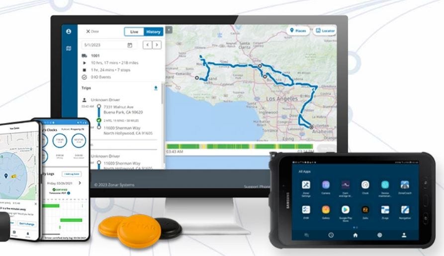
Zonar, which was founded in 2001, employed more than 300 people in North America. It was acquired by Germany-based Continental in September 2016. The company offers GPS, telematics hardware and software products for fleets in the construction, transportation and utility industries.
Zonar’s recent announcements consist of environmental fleet management solutions. In addition, the company has forged into school bus markets in the United States and Canada. In March 2024, Zonar launched the Zonar MyView app in Canada that provides parents and caregivers with real-time location updates for school buses.
For its part, Florida-based GPS Trackit, which was founded in 2002 and backed by equity firm Inverness Graham, is also an established fleet management software vendor. The company will operate Zonar as part of the GPS Trackit portfolio while maintaining its fleet health and safety solutions, particularly in the government and education sectors, the company said.
Embedded World 2025: GNSS Companies Display New Modules
Embedded World 2025, held this week in Nuremberg, Germany, allowed GNSS and telematics company to showcase new modules, antennas, sensors and other products. One company, IoT provider Telit Cinterion, rolled out the LE310 LTE Cat. 1 bis module series and the SL871K2 GNSS module at the trade show.
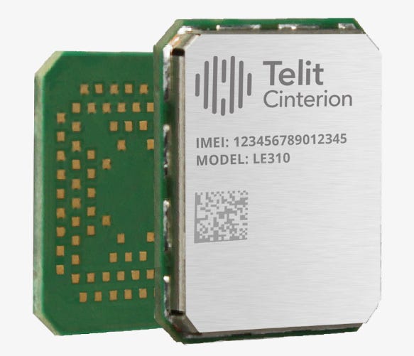
The company is marketing the modules for asset tracking, telematics, wearables and other applications. In addition, Telit Cinterion says its LE310 module series is the right size for constrained IoT devices such as asset trackers, Mobile Personal Emergency Response Systems (mPERS) and portable medical devices.
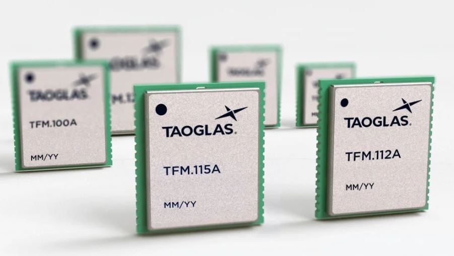
Taoglas has announced it expanded its line of TFM series of multi-band GNSS front-end modules at Embedded World. ““Using TFM modules typically saves designers at least six months of development time compared to designing active circuitry on the PCB themselves,” said Taoglas CEO, Dermot O’Shea, in a statement. “It not only speeds things up and enables them to focus on the rest of their design, but because of our many years of experience designing such circuits for our own antennas, you know you are getting best in class and can be confident in the reliability and accuracy of your GNSS data.”

Another company, Quectel Wireless Solutions, has launched its LG580P that supports multi-band signals across L1, L2, L5, and L6, enabling real-time kinematic (RTK) positioning and integrating a dual antenna, the company said. The module is tailored to intelligent robots and devices used in precision agriculture, ADAS and autonomous driving, the company said.
u-blox Launches DAN-F10N GNSS Antenna Module
Thalwil, Switzerland-based u-blox has launched the DAN-F10N dual-band GNSS antenna module at Embedded World. The company, which says the module is the industry’s smallest L1, L5 dual-band GNSS antenna module, says it features a dual-band patch antenna, packaging technology and a robust RF design.

The company says the module is tailored to such markets as asset tracking, aftermarket telematics, industrial automation and monitoring, consumer UAVs and sport trackers. The module offers meter-level positioning, enhanced performance, and seamless integration, the company said.
In other Embedded World News:
pSemi has launched the PE562212 IoT front-end module. The module can connect to wearables, sensors and asset tracking applications, the company said.
At the conference, Metirionic launched its Bluetooth Channel Sounding Evaluation Kit for the Nordic nRF54L15 to enable secure distance measurements and real-time location services (RTLS). Potential markets for the kit include real-time ranging and location accuracy for industrial, IoT, RTLS, logistics, and secure access applications.
Fibocom rolled out its Tracker Solution that is designed for vehicle and asset tracking, as well as two-wheeled vehicle TCU (Telematics Control Unit) applications. Fibocom provides tailored Cat.1 bis and GNSS modules, and antennas for various chip platforms.
oToBrite displayed its visual SLAM Positioning solutions for autonomous robots and uncrewed vehicles. In addition, the company said its Vision-AI perception technology powers ADAS applications, detecting lane, pedestrians, vehicles, and other road objects to enhance driving safety. This technology is already integrated into oToGuard, an all-in-one Level 2+ ADAS solution for commercial vehicles, the company said.
pSemi has launched the PE562212 IoT front-end module. The module can connect to wearables, sensors and asset tracking applications, the company said. The new IoT FEM enables higher data rate applications such as Wi-Fi and is powered by pSemi’s UltraCMOS technology, the company said.

Truesense and Sintropy have partnered to integrate UWB solutions into Sintropy's platforms. The integration will enhance equipment monitoring, preventive maintenance, and overall operational efficiency in industrial and medical environments, the companies say.
Weekly Location Industry News
News tip? Send them to kdennehy@driverlessreport.com. Go to www.locationbusinessnews.com for more news. Location Business News is looking for your company’s news, products and use cases to feature in each issue.
Top News:
📊 New Poll Shows Overwhelming Bipartisan Support for Building Ground-Based Backup to GPS. “NextNav NN 0.00%↑ has released a national Public Policy Polling survey that finds, by a margin of ten-to-one, voters support the creation of a ground-based complement and backup to GPS. Majority support is seen across various demographic categories such as gender, political party, and age groups.”
🛰 GMV To Support the Evolution of the Galileo Reference Centre. “The European Union Agency for the Space Programme (EUSPA) has awarded GMV a new framework contract for the evolution of the Galileo Reference Centre (GRC). The main mission of the GRC is to carry out independent monitoring of the Galileo system, providing EUSPA with detailed reports on its operation, the quality of the navigation signals transmitted, and the actual performance of the various services obtained at user level.”
🙁 UKMTO Receives Reports of Gps Interference in Strait of Hormuz. “UK Maritime Trade Operations (UKMTO) has received corroborating reports from vessels experiencing GPS interference in the Strait of Hormuz.”
🤞 Intelsat, Cochise County Sheriff’s Office Deploy Satellite Communications at Mexican Border. “Beyond voice communication, the system supports broadband connectivity critical safety features like GPS-based ‘officer down’ alerts, ensuring life-saving capabilities in the field.”
⚡ Qualcomm to Buy AI/IoT Specialist Edge Impulse to Drive Dragonwing Offer. “Qualcomm Technologies QCOM 0.00%↑ has signed a deal to acquire US-based Edge Impulse, which makes miniaturised machine learning (ML) tools for microcontrollers (MCUs) in resource-constrained IoT modules. Qualcomm has also picked up the LTE portfolio of France-based IoT specialist Sequans, at the end of last summer.”
👉 Semtech Boosted 5G Family. At last week’s Mobile World Congress, Semtech rolled out its Release 18 units, Japan meter pass and Skylo IoT samples.
😑 Is NB-IoT Losing Its Edge? Why Operators Are Turning to LTE, 5G and Satellite for 2025.

Expert nationwide installation services for fleet technologies.
Maps:
🌎 Esri Collaborates with Google Maps Platform to Photorealistic 3D Tiles. “At its 2025 Partner Conference, Esri announced a collaboration with Google Maps Platform. Enabling users to create highly detailed and visually immersive 3D maps and scenes, this collaboration integrates Google’s GOOG 0.00%↑ Photorealistic 3D Tiles into the ArcGIS suite.”
👍 GM's Chief of Maps Dave Craig Knows the Road — And Works to Fix Them. “This year, GM GM 0.00%↑ plans to drastically increase both the vehicles that use Super Cruise and the number of roads on which it is available. While entire divisions at GM focus on deploying its advanced driver-assist technology, only one man is known as the chief of maps. Dave Craig, 61, has that role for General Motors — the first person to ever hold the title. His job is instrumental in creating a digital road map for its driver-assist technology to navigate real-world environments.”
😐 Tesla Navigation Maps: What's Included and How to Update Them. “From the very beginning, Tesla TSLA 0.00%↑ chose to use its own proprietary Linux-based operating system instead of relying heavily on CarPlay and Android Auto. This also meant that it had to develop its own mapping solution that would live at the center of its infotainment space.”
✈ Creating a Google Maps for Airports. “Aviation Solutions, together with MappedIn, has taken on the challenge of developing a working solution for Schiphol, the main international airport of the Netherlands.”
🤔 Top 5 Google Maps API Alternatives for Location-Aware Apps in 2025. “One of Radar’s key advantages is its pricing model, which is often more affordable than the Google Maps API cost.”
👌 Ford Announces NACS Charger Integration for EV Routing in Apple Maps. “Ford F 0.00%↑ announced that the Mustang Mach-E and F-150 Lightning, which both support Apple Maps EV Routing AAPL 0.00%↑in CarPlay, will now be able to automatically direct drivers to the nearest NACS fast charging station whenever the vehicle needs to be charged.”
🌍 Gebeta Maps Launches Independent Map Tiles, Aiming to Disrupt Africa’s Digital Mapping Space. “Gebeta Maps, an emerging player in Africa’s digital mapping industry, has announced the launch of its own map tile rendering technology, positioning itself as a fully independent mapping provider.”
😦 Google Maps Could Get Android Auto Users in Trouble, Shows Addresses They Never Drove To. “A discussion thread on Google GOOG 0.00%↑ forums confirms that the bug isn't an isolated issue, as other users report the same behavior. Google Maps shows a random address when launching the app as if the user previously drove to this address.”
👏 Celebrating Mapping Maestro Chantal Govender of GeoINT.

Become a Paid Subscriber to Location Business News! Only $8 per month!
What Paid Subscribers get:
Full access to more than 200 Archived issues (stories, contacts, analysis).
A new subscriber-only Chat Board.
Access to Analysis and In-Depth Articles, plus People and Jobs.
Free entry to LBN-branded webinars and receptions at major trade shows (in development).
Steep Advertising Discounts for paid subscribers and Founding Members.
We average 30,000 views on our websites each month. Advertising starts at only $150 per issue. Please contact us at info@driverlessreport.com for more information…or go to our updated Advertising Page.
Connected and Autonomous Vehicles:
🙂 Waymo Expands its Robotaxi Service Across Silicon Valley. “The Waymo vehicles will be available around-the-clock, and the new territories add to the 55 square miles of coverage already offered in the San Francisco Bay Area, the company said Tuesday.”
👍 Entropy Robotics Works With SRI to Advance Autonomous Navigation in Challenging Environments. As part of the collaboration, Entropy Robotics will receive intellectual property from SRI's visual navigation suite, enabling autonomous navigation in austere and GPS-denied environments.
🚘 Japan's Nissan Tests Driverless Vehicles in City Streets Filled With Cars and People. “The driverless technology from Nissan Motor Corp., which uses 14 cameras, nine radars and six lidar sensors installed in and around the vehicle, highlights Japan’s eagerness to catch up with players like Google’s GOOG 0.00%↑ Waymo that have taken the lead in the U.S. Waymo is going to land in Japan this year. Details haven’t been disclosed, but it has a partnership with major cab company Nihon Kotsu, which will oversee and manage their all-electric Jaguar I-PACE sport-utility vehicles, first in the Tokyo area, still with a human cab driver riding along.”
🥇1.5 Million Kia Connect Users and Counting. “In 2019, still known under the name UVO Connect, roughly 32,500 users were registered for the service. Over the years, Kia Connect has experienced exponential growth – more than tripling its user base between 2021 and 2024 with an increase of 32 percent just between 2023 and 2024.”
🤷♂️ Pony.ai CEO on Tesla's Robotaxis: 'We Haven't Seen Their Large Scale Testing Yet.' “The co-founder and CEO of Pony.ai refused to be drawn on whether he thinks Tesla TSLA 0.00%↑ will launch its robotaxi service this year.”
🚗 NTT Data’s Transatel teams with Toyota for connected cars in LATAM. “NTT Data announced that its global cellular connectivity subsidiary Transatel has formed a partnership with Toyota Motor Corp. to support the carmaker’s deployment of connected vehicle services in Latin America. Under the partnership deal, Transatel multi-network (e)SIM cards are now integrated into Toyota vehicles produced for the LATAM market.”
Fleet Telematics:
🚍 Trimble and Daimler Truck North America Modernize Truck Maintenance with New Integration. “Trimble TRMB 0.00%↑ and Daimler Truck North America (DTNA) have announced the integration of Trimble Road Call, a vehicle breakdown module within the Trimble TMT Fleet Maintenance solution, with Freightliner Service Tracker. This integration streamlines the repair process for commercial fleets by combining the capabilities of both software solutions.”
🚚 Geotab and Thermo King Collaborate to Preserve Perishables.
👍 BeWhere Partners with GISCAD to Deliver Advanced Asset Tracking Solutions to Caribbean Markets. “BeWhere and GISCAD Barbados, a Geotab reseller, have partnered to offer asset tracking. The deal will leverage BeWhere's new LTE Cat1 Bis based BeSol+ and BeWired+ devices and GISCAD's regional client footprint across 29 territories in the Caribbean and Latin America.”
📊 Midland Tyre Services Reduces Accidents Across its Fleet by 54% with Samsara. “Through integrated telematics, GPS tracking, and dual-facing AI Dash Cams, Midland Tyre Services has gained greater visibility into individual driver performance and reduced accidents by 54 percent over the last two years.”
📌 Teletrac Navman Survey Finds 83% of Fleets Say That AI Is Future of Safety. “As such, 32% of respondents said that AI will effectively be used to monitor driver behavior in real time and to reduce distracted driving incidents (16%); predicting and preventing potential accidents (17%); improving vehicle maintenance (14%); and enhancing training / coaching through data insights (13%).”
🚐 KCS acquires Ram Tracking. “UK based software provider Kerridge Commercial Systems (KCS) has acquired vehicle tracking and fleet management specialist Ram Tracking. The acquisition marks KCS's sixth purchase in the past 12 months. Ram Tracking provides mobile work management solutions including vehicle tracking, video monitoring, fleet management and driver compliance systems. The company currently serves more than 22,000 small and medium sized business customers across Europe and North America.”
🚛 GearTrack and Verisk CargoNet Team Up for Enhanced Cargo Theft Protection and Recovery. “GearTrackand CargoNet announced a collaboration incorporating Verisk CargoNet’s RouteScore API, a risk-scoring algorithm, into GearTrack’s platform.”
🚚 Platform Science and Cummins Partner to Introduce Vehicle Health Intelligence. “Platform Science and Cummins have partnered to introduce Vehicle Health Intelligence. Cummins will transition their Connected Solutions portal, which enables fleets to access a range of features and capabilities to the Virtual Vehicle platform.”
🚙 OCTO has been Selected by ABAX Group as its New Risk Scoring Partner for UBI Insurance.
Financial:
💰 Shield AI Lands $240 Million to Expand Drone Autonomy Tech. “Shield AI, a deep-tech company known for pushing the boundaries of AI-driven autonomy, has secured a whopping $240 million in a new funding round, bringing its valuation to $5.3 billion.”
💲 Nirvana Raises $80 Million for AI-Powered Insurance for Truck Drivers and Fleet Operators. Nirvana Tech, a startup that blends artificial intelligence with detailed vehicle tracking data to offer insurance to truckers, today announced it has raised $80 million in a Series C funding round.”
✔ NextNav Inc. Reports Fourth Quarter and Full Year 2024 Results.
✔ NextNav Announces $190 Million of 5% Redeemable Senior Secured, Convertible Transaction.
✔ STMicroelectronics Announces Status of Common Share Repurchase Program.
✔ Urgent.ly Inc. Announces Reverse Stock Split to Regain Nasdaq Compliance.

The D-Day Visitor's Handbook: Your Guide to the Normandy Battlefields and WWII Paris by Kevin Dennehy and Steve Powers. The guidebook uses location technology from what3words to locate monuments, museums and other attractions. Get your guidebook today.
Weekly Product News
Send your news releases to kdennehy@driverlessreport.com. Go to www.locationbusinessnews.com for more news and an archive of stories.
C.J. Driscoll & Associates Releases New Study of the U.S. Commercial Telematics Systems Market
C.J. Driscoll & Associates has released the 324-page 2025-26 U.S. Mobile Resource Management Systems Market Study that says 25 million GPS/wireless devices and dashcams are used to manage fleet vehicles, trailers, construction equipment, and field service workers. By 2028, the market will expand to more than 34 million units and revenues will exceed $12 billion, the study says.

The fastest-growing sector in commercial telematics is video telematics, the study says. “Video is penetrating all fleet segments, particularly trucking, due to the desire of fleet operators to determine liability in the event of an accident and for driver coaching,” the study says. In addition, the study says that significant merger and acquisition activity has been occurring as recently as late 2024, which shows the ongoing confidence of both strategic and financial investors in the near and long term prospects for the industry.
Contact: Clem Driscoll, C.J. Driscoll & Associates, (310) 717-7961, clemdriscoll@cjdriscoll.com, www.cjdriscoll.com.
Swift Navigation Supports Survey-grade Location in Utility Locator and Mapping Device
Swift Navigation has announced that Vivax-Metrotech validated Swift’s Skylark Precise Positioning Service to power centimeter-accurate utility mapping with its vLoc3 RTK-Pro receiver. Vivax-Metrotech’s vLoc3 RTK-Pro receiver is the first utility locator to fully integrate precise GNSS with Real Time Kinematic technology, the company said.

The receiver allows teams to locate buried infrastructure and map its position with survey-grade accuracy using a single handheld device, the company said. With Skylark, the vLoc3 RTK-Pro receives GNSS corrections to achieve accuracy within two centimeters, eliminating the need for a local RTK base station, the company said.
Contact: Swift Navigation, press@swift-nav.com,www.swiftnav.com.
Quectel Launches 5G Transparent Antenna
At last week’s Mobile World Congress in Barcelona, Quectel Wireless Solutions launched the YFCX001WWAH 5G transparent antenna. The ultra-thin design antenna is suitable for wearables, automotive, and industrial applications across multiple industries, including VR and AR wearables, automotive, smart agriculture and smart cities, the company said.

Contact: Quectel, media@quectel.com, www.quectel.com.
Combain Mobile Updates Logo, Website and Brand
Combain Mobile has announced it updated its logo, website and updated its brand.
Combain says its new logo embodies their technological expertise and commitment to location precision.
Contact: Combain Mobile, https://combain.com.
Teltonika Launches GPS Trackers
Teltonika has launched its FTx305 series of GPS trackers for e-mobility and other markets. The company says the e-mobility market covers a wide range of use cases, from e-bikes and e-bicycles to industrial machinery monitoring, such as e-forklifts and e-city cleaning vehicles.
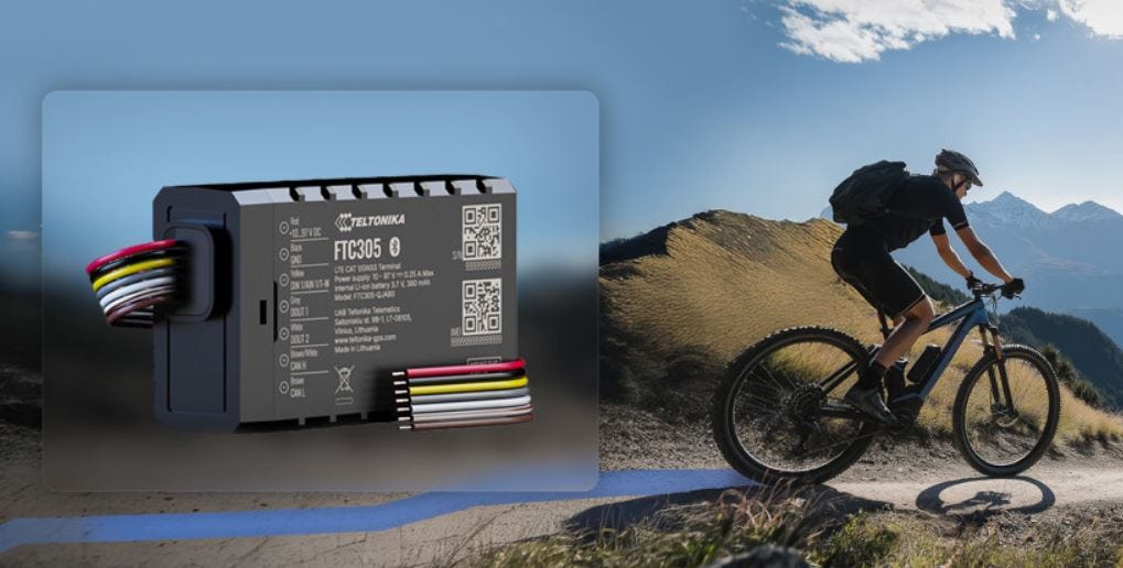
The company offers a 'no-casing' version of FTC305. Designed for OEM in-factory implementation, it can be installed in e-bikes and e-bike frames with an external antenna for connectivity and an external battery for tracking, the company said.
Contact: Teltonika, www.teltonika-gps.com.

Create a FREE ManyMe Account.
Golden Software Upgrades Surfer Mapping Package with Google Maps Downloads and Enhanced 3D Visualization
Golden Software has added the ability to download georeferenced Google GOOG 0.00%↑ aerial and satellite images to map projects in the latest version of its Surfer mapping and 3D visualization package. Other new features focus on faster and simpler creation of 3D visualizations that are easier to interpret and understand, the company said.

Surfer is used by more than 100,000 people worldwide, many involved in environmental consulting, water resources, engineering, mining, oil and gas exploration, and geospatial projects. The Base from Server command now gives users online access to global maps and aerial/satellite images from Google Maps for download directly into their Surfer projects as georeferenced base maps, the company said.
Contact: Golden Software, 303-279-1021, www.goldensoftware.com.
FindAD Features Location-Based Advertising with Real-Time Geofencing Alerts
FindAD features GPS tracking and geofencing technology to discover, create and manage ads in real-time, the company said. FindAD allows businesses and individuals to place ads based on geographic locations, ensuring higher engagement and relevancy, the company said. Its solutions features real-time GPS-based ad discovery, geofencing alerts and ad management.
Contact: FindAD, (850) 935-4560, support@findad.org, https://findad.org.
Virtual Surveyor Adds Topographic Design Tools to Smart Drone Surveying
Virtual Surveyor has added Basic Topographic Design tools to Version 10 of its smart drone surveying package, allowing users to design simple terrain changes, such as graded roads, water ponds, and flat building surfaces, on top of their surveys. Virtual Surveyor allows users to create 3D survey products from UAV-derived images and lidar data, the company said.

In Version 10, a new Mountain plan has been added between Ridge and Peak, and all three are differentiated by the concept of Time. All subscription plans, including the free Valley, now offer the Walk Mode which allows the user to “walk” through the 3D survey and view the terrain at ground level, the company said.
Contact: Tom Op ‘t Eyndt, Virtual Surveyor, (917) 789-1555, www.virtual-surveyor.com.

Click HERE to Join our growing Location Business News LinkedIn Group!
Senator Says Deputy Defense Secretary Nominee Could Financially Gain from Ligado Lawsuit
Democratic Sen. Elizabeth Warren is slamming deputy defense secretary nominee Stephen Feinberg’s ties to Ligado Networks saying that Feinberg’s Cerberus Capital Management, or his own family, could financially benefit from the ongoing, $39 billion lawsuit that Ligado is embroiled in with the U.S. government.
Keep reading with a 7-day free trial
Subscribe to Location Business News to keep reading this post and get 7 days of free access to the full post archives.