U-Blox Sees Record Automotive Project Awards
Automated driving spurs GNSS module growth--and potential revenues of $100 million starting in 2026
Thalwil, Switzerland-based u-blox [UBXN] has announced new project awards with “major automotive customers” in the Asia-Pacific region, enabling more than $100 million in expected revenue that will start in 2026. While the company didn’t name the automakers because of nondisclosure agreements, it said that upcoming vehicle models will incorporate u-blox’s GNSS F9 platform for automated driving.
While the auto projects are long term, along with the expected revenue generated from them, u-blox believes the automated driving market will continue to grow as it is working with the leading companies in that segment, said Stephan Zizala, u-blox CEO.
“Autonomous driving requires a reliable absolute position. [Our] GNSS solutions are precise, reliable and support functional safety,” Zizala said. “Therefore, we expect autonomous driving to be a long-term growth driver for u-blox.”
The new project wins are in addition to earlier contracts in 2023, the company said. The use of GNSS positioning solutions for advance driving assistance, particularly for lane-level guidance, will increase to 32 percent by 2030—an increase from 10 percent last year, according to ABI, TSR and u-blox market research.
In other company news, u-blox’s board of directors has appointed long-time Ericsson ERIC 0.00%↑ executive Camila Japur as CFO. Japur, who will be a part of the board’s executive committee starting July 1, will replace Roland Jud, company CFO since 2011. Jud will stay in a consulting role and will leave the company by the end of the year.
Expert nationwide installation services for fleet technologies
Geotab and Daimler Truck North America Partner on Telematics Offering
Geotab has partnered with Daimler Truck North America (DTNA) to integrate direct truck data from Freightliner trucks via DTNA's data-as-a-service (DaaS) technology and the MyGeotab fleet management platform. The announcement, made at the Geotab Connect event in Las Vegas this week, makes data from various OEMs and Geotab’s GO devices available on one platform, the company said.
Geotab says that many OEMs want to harness the potential of their vehicle’s data—and the partnership with DTNA allows them to accelerate the process with an easy to integrate solution.
In other Geotab Connect event news, the company rolled out its Geotab Ace AI copilot for fleets that offers insights through intuitive dialogue, the company said. Geotab Ace distills billions of data points daily to simplify insights and streamline access to information, the company said.
"By bringing the intuitive simplicity of conversational AI directly into the Geotab platform, we are transforming the way fleets interact with their data, crafting a future where insights are immediate, intelligent, and instrumental to success," said Mike Branch, Geotab vice president of data and analytics, in a statement.
Geotab Ace allows access to predictive safety analytics, predictive maintenance, trip data, zone activity, electric vehicle statistics, exception events and GPS tracking, the company said.
The D-Day Visitor's Handbook: Your Guide to the Normandy Battlefields and WWII Paris by Kevin Dennehy and Steve Powers. The D-Day Visitor’s Handbook includes everything you need to know to plan and make your visit to the site of the biggest seaborne invasion in history. This compact guidebook not only describes the most significant land invasion of World War II, but provides detailed battlefield maps and tours, identifies monuments and attractions, and locates museums and historical sites to make your planning easier and less stressful.
The guidebook uses location technology from what3words to locate monuments, museums and other attractions. Get your guidebook today!
Trimble Reports 2023 Earnings, Gives 2024 Guidance
Trimble $TRMB reported nearly $3.8 billion in 2023 revenue—a 3 percent year-over-year increase—and expects to report income between $3.57 billion and $3.67 billion this year.
In its 8-K filing, Trimble said GAAP net income was $311.3 million and non-GAAP net income was $663.7 million in 2023. During the year, the company also repurchased 2.4 million shares for $100 million.
"We finished 2023 with a record level of ARR, Gross Margin, and Adjusted EBITDA," said Rob Painter, Trimble's president and CEO, in a statement. "We enter 2024 with resolve to continue executing our strategy and returning capital to shareholders, while navigating macroeconomic uncertainties."
The company also reported its fourth quarter earnings, which was $932.4 million—up 9 percent on a year-over-year basis. For the first quarter of 2024, Trimble said expects to report revenue between $905 million and $935 million and non-GAAP EPS of 57 cents to 62 cents.
A strong market for Trimble has been in transportation, with bookings for its Transporeon subsidiary achieving 20 percent growth over the last year, according to FreightWaves. Germany-based Transporeon, a logistics company, was acquired by Trimble in December 2022 for $1.98 billion.
Despite increased revenues from Transporeon, compared to a strong North American segment, the European market has been disappointing for Trimble, the company said.
Opinion
Is the US Falling Behind China in the Race To Claim LEO Slots?
By Ashu Pande
Two recent announcements this week related to LEO satellites are worth taking note. Both are coming from China and show the trajectory Chinese companies after taking to align with China's latest five-year plan for 2021-2025.
Beijing has called for an integrated network of satellites for communications, remote sensing and navigation. Here are the announcements: Shanghai-Backed Firm Raises $933 Mln To Build Satellite Constellation and Geely Launches 11 Satellites to Navigate Autonomous Vehicles.
While one can argue that these initiatives in China are a bid to catch up with US's Starlink, the ability of a single network to support communications, remote sensing and navigation warrants attention and respect. Most LEO systems, operational or announced, in US are optimized for a single function: communication, navigation, or remote sensing.
Mass manufacturing capacity is a hallmark of Chinese companies. Geely established a $326 million satellite mass manufacturing factory in Taizhou in March 2020, which will have an estimated production capacity of over 500 satellites per year.
Tony Wang, CEO and chief scientist of Geespace said: “Many favorable factors such as policy support and market demand is accelerating the growth of the commercial aerospace sector. By establishing the Geely Future Mobility Constellation, Geespace is positioning itself to meet future user demands for high-precision positioning, space-based communication, and remote sensing services.”
This industry is ripe for investment in companies that have a good product market fit and business models spanning commercial and defense applications. It is time venture investors in the US see the opportunity.
Contact: Ashu Pande, dayadvisors@gmail.com.
Other Location News
News tip? Send them to kdennehy@driverlessreport.com. Go to www.locationbusinessnews.com for more news and an archive of stories. Location Business News is looking for your company’s product use cases to feature in each issue. Send us five paragraphs and an image/photo for consideration. Include a contact name, phone, email and web address.
Top News:
😕 Iridium Weighs in on Ligado's Lawsuit Against US Government. “The Air Line Pilots Association, Airlines for America, and the International Air Transport Association joined Iridium in a legal filing to the Court of Federal Claims Feb. 9, detailing their support for the government’s motion to dismiss the lawsuit.”
🏛 Samsara Follows Lawsuit Against Motive With ITC Complaint. “Samsara IOT 0.00%↑ has filed a complaint against fleet management provider Motive Technologies with the International Trade Commission. This follows Samsara’s recent filing of a federal lawsuit against Motive, seeking damages for its losses due to alleged intellectual property theft.”
✔ BAE Systems Wins Approval for Ball Aerospace Acquisition. “BAE Systems will complete its $5.5 billion acquisition of Ball Aerospace BALL 0.00%↑ in days after securing regulatory approvals for the deal.”
🛰 Space Force May Launch GPS Demonstration Satellites To Test New Tech. “Space Systems Command, the service’s primary acquisition organization, said in a Feb. 5 notice it is conducting market research to refine its concept for a constellation of GPS demonstration satellites.”
📌 Satellite Operators Join Forces To Chase Direct-To-Smartphone Opportunity. “Viasat, Terrestar Solutions, Ligado Networks, Omnispace, and Yahsat announced the creation of the Mobile Satellite Services Association (MSSA) Feb. 9, a non-profit aiming to harmonize Mobile Satellite Services for integrating with standardized devices.”
🚒 AT&T, Firstnet Announce Ten-Year Investment Program. “Having completed the initial deployment of the FirstNet network for first responders, AT&T T 0.00%↑ and the First Responders Network Authority announced that they expect to invest $8 billion in to the network over the next 10 years.”
Maps:
🙂 Google Maps Overhauls Its Navigation Experience With a Redesign. “The navigation UI now includes a floating box with rounded corners for the origin and destination, making it look more intuitive and modern.”
👌 Google Maps Is Getting an AI-Boosted Upgrade To Be an Even Better Navigation Assistant and Your Personal Tour Guide. “It looks like Google is going all-in on artificial intelligence (AI), and following the rebranding of its generative AI chatbot from Bard to Gemini, it’s now bringing generative AI recommendations to Google Maps.”
👍 Niantic Joins Overture Maps Foundation. “Niantic will participate in the Data Working Group and contribute geolocation data. Overture’s open source map data will augment the dynamic Niantic Map used to power Niantic’s games and developer platform.”
📱 Google Maps Goes To Extreme Lengths To Create a Detailed Immersive View. “Cameras mounted on cars and backpacks are used to gather Street View imagery, which is combined with aerial cameras for 3D models.”
🤔 The Quest to Map the Great Indoors. “The quest to map building interiors addresses not just the challenge of navigation but also safety and operational efficiency in densely inhabited spaces.”
🌍 Wayfinder App Bindimaps Enhancing Cinema for Low-Vision Moviegoers. By delivering real-time navigation information via audio, text or map cues and audio directions optimized for people with vision impairment, the inclusive wayfinding mobile app enables people with a disability to navigate complex and unfamiliar indoor spaces like hospitals, multi-level office buildings, universities and shopping centers, or events like the Australian Open.”
🗺 Enhancing Basemaps with ArcGIS Basemap Styles v2: Introducing Basemap Places and Worldview. “ArcGIS Basemap Styles (v2) has been designed to enhance the way developers tell stories with basemaps.”
Reach nearly 14,000 subscribers and 100,000 more via social media by advertising in Location Business News!
We can promote your webinar, service or product to a focused group of industry executives. Email us at info@driverlessreport.com for more information, or click here to view our one-page media kit.
Connected and Autonomous Vehicles:
🚗 US Considering Curbs To Keep Chinese 'Smart Cars' Out of the Country. “The Biden administration is considering restricting imports of Chinese "smart cars" and related components amid growing U.S. concerns about data security.”
😐 Waymo Issues a Voluntary Recall on Its Self-Driving Vehicle Software. “Waymo announced a voluntary recall of its self-driving car software following two incidents involving its vehicles in Phoenix, Arizona.”
🤷♂️ Chinese Technology Company Lashes Back at US Claims It Has Ties to Military. “Hesai Technology’s core product is lidar road sensing equipment, used in passenger and commercial vehicles, autonomous driving vehicles, delivery robots and other applications. It was among 17 companies the U.S. Department of Defense recently added to its list of companies it considers “Chinese military companies.”
😮 Waymo Car Vandalized, Set on Fire in San Francisco:
🚘 Toyota to Launch Japan’s First Fully Automated Driving Service on Public Roads Starting in Odaiba, Tokyo, This Summer. “The [Level 4] service will be provided in cooperation with Monet Technologies Inc., a company jointly funded by Toyota and SoftBank Corp., utilizing a self-driving system from U.S. startup May Mobility.”
🤞 Mobileye CEO Shashua Expects More Autonomous Vehicles on the Road in 2 Years as Tech Moves Ahead.
🤦♂️ Dude, Where's My Self-Driving Car? “The many, many missed deadlines for a fully autonomous vehicular future.”
Drones:
🏭 The Use of S.L.A.M. Techniques and Autonomous Drones in Inventory Management.
✔ BlueHalo Acquires Eqlipse for Advanced Defense Applications. “The company’s business spans several verticals within the defense sector including autonomous systems of which drones, tracking, and swarm tech fall under this category.”
🛩 DIU Picks 3 Companies to Prototype Large Undersea Drones for Navy. “The Defense Innovation Unit today announced it had selected three companies to develop and prototype unmanned undersea vehicles with a focus on employing payloads for subsea and seabed warfare as well as undersea warfare.”
Financial:
💰 BMW I Ventures Invests in Skylo Technologies; Direct-To-Device Satellite. BMW i Ventures has invested in Skylo Technologies, a direct-to-device satellite connectivity service provider. The $37-million financing round was co-led by Intel Capital and Innovation Endeavors Connectivity.
💲 Signal Ocean to Make $10 Million Strategic Investment in Spire Global.
✔ Iridium Announces 2023 Results; Company Issues 2024 Outlook.
ION Offers Complimentary Drone Presentation
The Institute of Navigation is offering a complimentary webinar featuring Aman Sharma on Feb. 28 at 12 p.m. EDT.
To register, go to: ion.org/publications/webinars.cfm.
Location Industry Briefs
Send your news releases to kdennehy@driverlessreport.com. Go to www.locationbusinessnews.com for more news and an archive of stories.
Geo Week 2024 Offers New Industry Products and Applications
Geo Week 2024 in Denver this week offered several industry panels on drones, survey, lidar, mapping and other topics. It is also becoming a strong conference for launching mapping, survey and drone products…
Geo Week press releases:
Inertial Labs Unveils the new GEN-II RESEPI scanning and mapping solution
Capturing Tomorrow: FJDynamics Reveals New 150MP Aerial Mapping Camera at Geo Week 2024
Integration of Mosaic’s High Resolution 360º Camera with Laser Scanning Solutions
Esri Releases New ArcGIS Reality Software to Capture the World in 3D
HERE Achieves AWS Automotive Competency
HERE Technologies has achieved the Amazon Web Services (AWS) Automotive Competency. The specialization tags HERE for its expertise in providing customers with professional services in Advance Driver Assistance System (ADAS), autonomous vehicle, connected mobility, digital customer engagement, sustainability, electric vehicle, supply chain, and software defined vehicle strategic workloads, the company said.
To receive the AWS Automotive Competency designation, AWS Partners must undergo a rigorous technical validation and provide vetted customer references, the company said. This is the third AWS Competency designation HERE has received, having previously received the AWS Supply Chain Competency and AWS Public Sector/Disaster Response Software Competency, the company said.
Contact: Reed Findlay, HERE Technologies, (703) 966-6284,
Reed.findlay@here.com, www.here.com.
Link Labs' AirFinder Solution Now on the Geotab Marketplace
Link Labs' AirFinder Everywhere solution for trailer tracking and logistics visibility is now available on the Geotab Marketplace, the company said. AirFinder Everywhere solution is designed to provide visibility for a logistics company's non-powered assets. It is designed to integrate with telematics and supply chain management systems to provide new sources of data, the company said.
Contact: Link Labs, www.link-labs.com.
Farnell Announces New Distribution Partner Agreement With Taoglas
Farnell has announced a distribution agreement with Taoglas that allows the company to offer customers an expanded RF and wireless product offering. Farnell and its global brands, Newark and element14, offer products North America, Europe, and Asia.
Taoglas’ offers antennas and RF components covering cellular, GPS/GNSS, Wi-Fi, Bluetooth, UWB, NFC/RFID, LPWA, ISM band, and satcom applications.
Contact: Taoglas, www.taoglas.com.
Appdome Launches Geo Compliance Feature Set
Appdome rolled out its Geo Compliance feature set, allowing mobile brands to trust the user's location and detect location spoofing, fake GPS apps, VPN use, SIM swaps and other methods used to circumvent geo restrictions in mobile applications. Mobile brands can combine Appdome's new, no-code, no-SDK, Geo Compliance features with any other mobile app defense features on its unified mobile app defense platform, the company said.
Contact: Appdome, www.appdome.com/geo-compliance.
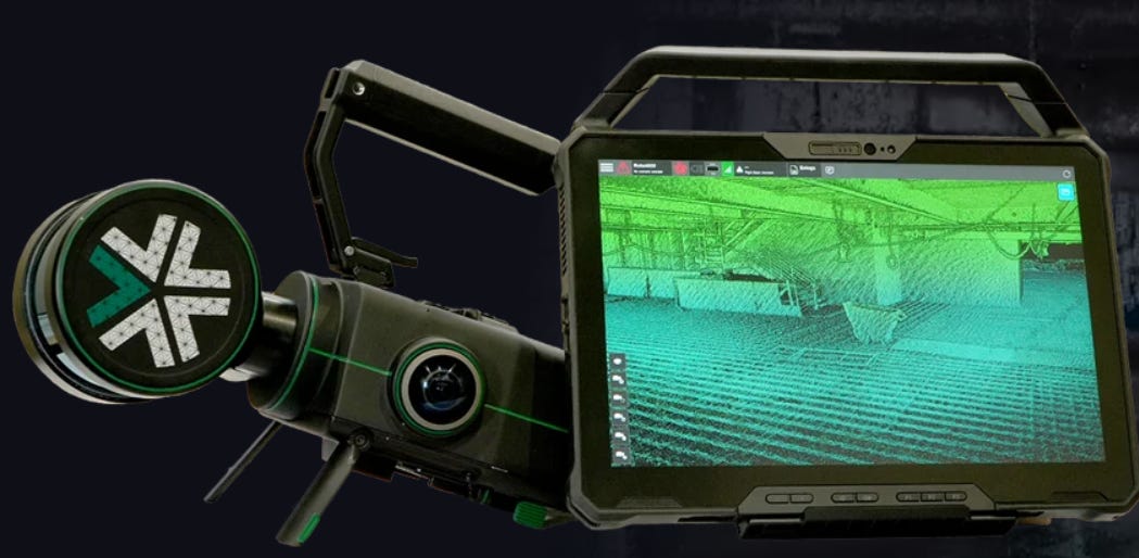
Exyn Rolls Out Nexys 3D Mapping Solution
Exyn Technologies has launched Nexys, a modular 3D mapping solution. The product is designed for the mining, construction, AEC, and geospatial industries.
Nexys is equipped with lidar, proprietary SLAM algorithms and can operate in GPS-denied settings. Nexys includes GPS modules, protective cages, and Drone Link for robot integration, the company said.
Contact: Exyn Technologies, www.exyn.com.
Woolpert Invests in Leica Geosystem’s Pegasus
Woolpert has invested in Leica Geosystem’s Leica Pegasus TRK700 Neo to augment its geospatial data collection capabilities. This new mobile mapping system will be used to conduct aviation and transportation infrastructure surveys to support asset management and inventories, statewide GIS solicitations, and other state department of transportation needs. The TRK700 Neo uses a combination of high-precision GNSS positioning, inertial measurement units, and lidar data to generate accurate 3D point clouds of the surrounding environment, the company said.
Contact: Woolpert, woolpert.com.
Create a FREE ManyMe Account.
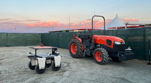
FarmX Presents Autonomous Navigation Without GPS
FarmX has launched its Perceptive Navigation vehicle autonomy in demonstrations at the 2024 World Ag Expo. FarmX offers autonomous vehicle navigation without GPS or connectivity on vehicles equipped with Perceptive Navigation, the company said.
Unlike traditional GPS-dependent systems, FarmX’s robotics platform allows navigation in complex agricultural environments such as dense foliage, mountainous terrain, adverse weather, and low-visibility scenarios, the company said. The platform can be licensed for tractors, rovers (UTVs, ATVs) and drones.
Contact: Sarah Levin, FarmX, sarah@farmx.ag, www.farmx.ag.
Capella Space Partners With TCarta
Capella Space has announced a partnership with TCarta to add high-resolution SAR satellite imagery to TCarta's coastal monitoring and shoreline feature extraction solutions. This partnership will allow identification of coastline changes, so coastal managers have the accurate and up-to-date information for mitigating the impacts of climate change, the company said. TCarta's technology will leverage Capella's automated satellite tasking system to synchronize SAR imagery collections to match up with real time tidal fluctuations, the company said.
Contact: Capella Space, www.capellaspace.com.
Fairview Microwave Rolls Out Military-Grade Antennas
Fairview Microwave has launched military-grade antennas that include ruggedized GPS, manpack omni, and vehicle omni antennas. Fairview's military-grade antennas meet MIL-STD-810 standards, the company said.
In addition, the antennas are TAA-compliant (Trade Agreements Act), making them suitable for government and defense applications where compliance is non-negotiable, the company said.
Contact: Fairview Microwave, (972) 649-6678, infiniteelectronics.com.
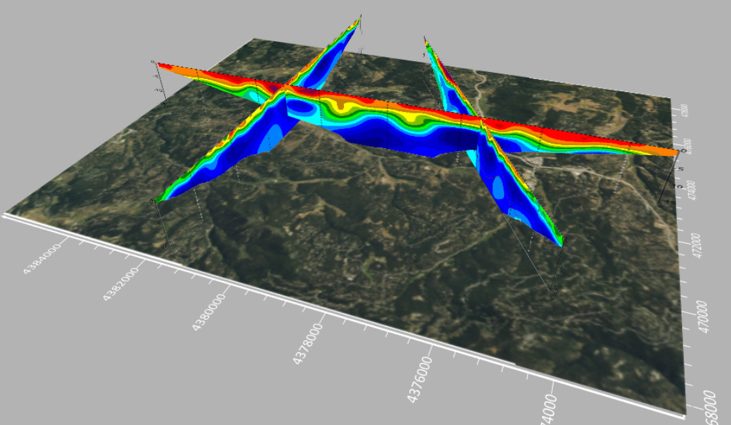
Latest Surfer Mapping and 3D Visualization Package from Golden Software
Golden Software has enhanced the 3D visualization capabilities of its Surfer mapping and 3D visualization software, the company said. The expanded visualization tools make it easier to create 3D grid files for the viewing and analysis of drillhole data, the company said.

More than 100,000 people use Surfer worldwide, many of which are involved in environmental consulting, water resources, engineering, mining, oil & gas exploration, and geospatial projects, the company said.
Contact: Golden Software, (303) 279-1021, www.goldensoftware.com.
People
Cruise LLC has announced it has hired automotive safety leader Steve Kenner as its Chief Safety Officer.
LandAirSea Systems, which designs and builds GPS tracking technology for fleet management, has appointed Hall of Fame NFL wide receiver Cris Carter to its board of directors.
Maxar appointed Arvind Srinivasan as CTO.
CompassData has appointed Kate Schlatter as CEO,
Marius Swanepoel has been appointed director maps - Map Experts at TomTom.
Hamdy Elsayed, innovation manager at Teledyne Geospatial, has been named "Robert E. Altenhofen Memorial Award" recipient at Geo Week in Denver.
Furqan Ahmed has been been named senior GNSS scientist at TrustPoint.
Jobs
Regional Marketing Manager (APAC, Japan based). TomTom.
Sr. Product Manager - Autonomous Driving. TomTom.
Senior Vice President Information Technology. Orbcomm.
Site Reliability Engineer. Point One Navigation.
Proposal Manager - Hybrid/Remote. Woolpert.
Head of System Product Development. CrossInt (Septentrio).
Sr. Analyst/Manager– Business Operations. Mobilisights.
Senior Account Executive. Airspace Link.
Click HERE to Join our growing Location Business News LinkedIn Group!


