


u-blox Transfers Cellular IoT Business to Trasna
See paid subscriber analysis, Apple using businesses to update Maps, plus Jobs and People.

Hexagon Completes Acquisition of Septentrio, Names Dale President of Autonomous Solutions
Hexagon announced this week that it closed the acquisition of Leuven, Belgium-based Septentrio NV for an undisclosed figure. Hexagon, which made the initial announcement in January, hasn’t said if there will be personnel consolidation or layoffs at Septentrio, which employs 150 people worldwide.
Hexagon did say Septentrio, with 50 million euros in sales last year, will be rolled into its Autonomous Solutions division. The company said it would merge Septentrio’s GNSS platform with its larger positioning technology portfolio of sensor fusion, anti-jamming systems, correction services and perception technologies.
The company integration focus will be on emerging autonomous systems adoption and other markets, the company said. These markets include robotics, UAVs and defense applications.
The Autonomous Solutions division has a new boss, longtime employee Gordon Dale, who has been with the company since 2008. Dale was the division’s co-president, COO and vice president of engineering.
“Combining Hexagon’s extensive positioning portfolio with Septentrio’s innovative GNSS platforms will provide our customers with cutting-edge solutions, enabling autonomy and mission-critical applications for diverse markets,” Dale said, in a statement.

Are you ready for your next Trade Show? JB Media is your one-stop shop for printing, promotional products and corporate wearables. Let us help you prepare for your next show! Visit our website, e-mail us at Service@JimBrownMedia.com or call us direct at (720) 588-0493.
Snap Integrates GPS, GNSS into Developer-Centric Spectacles
Snap SNAP 0.00%↑ announced this week that it’s integrating GPS/GNSS capability for its Spectacles-focused Lenses to improve location-based experiences for developers and users.
While it’s only been about six months since the company released the fifth generation of AR Spectacles, new hand-tracking capabilities, compass heading, and custom locations will allow developers to integrate geo-location data for a variety of applications, the company said.

The company said that NavigatAR Lens from Utopia Labs is an example that shows how GPS, Snap Map Tiles and compass heading can be used to help users navigate from one point to another. Another example the company gave is Path Pioneer, which Lens “provides building blocks for creating indoor and outdoor AR walking courses that keep you active.”
The hand hand-tracking capabilities include a phone detector to identify when a user has a phone in their hands. Another is a grab gesture and one that makes refinements to targeting intent to reduce false positives while typing, the company said.
Spectacles are available through the company’s $99 per month developer program. The company also announced a series of challenges, starting April 1, that gives $20,000 to developers who create the best Lenses each month.
Waymo Gets Approval to Map San Francisco Airport
Waymo has won a 30-day permit to map roads at San Francisco International Airport (SFO). While the company won’t be allowed to carry public passengers, the permit gives it the opportunity to begin aggregating data to allow its cars to navigate roads in and out of the potentially lucrative airport.
San Francisco Mayor Dan Lurie’s news release said that the permit is valid through April 13, with an option to extend it by 30 days. The permit calls for a human driver to operate the mapping vehicles—with only two vehicles allowed to operate at a time. The occupants must be Waymo employees and airport personnel.
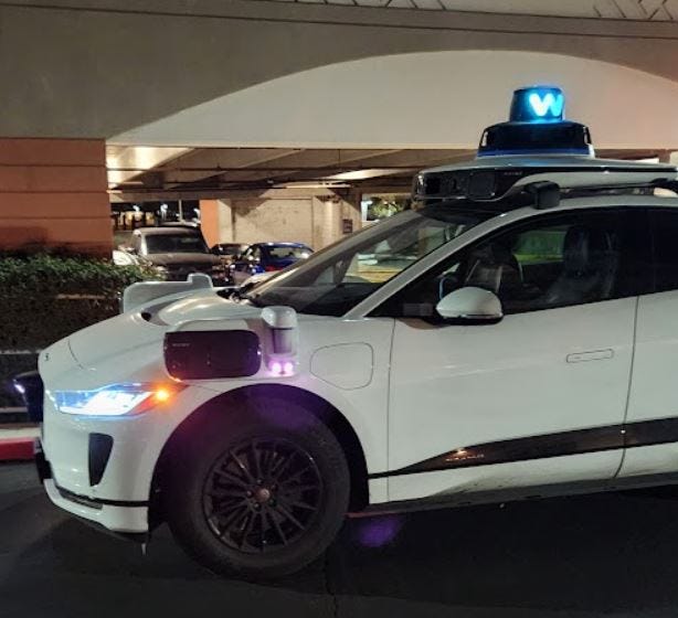
The permit represents a big win for Waymo as Uber UBER 0.00%↑ and Lyft LYFT 0.00%↑ operate thousands of rides to SFO each week. In fact, Waymo was rejected for a permit in 2023.
Not everyone is happy about Waymo mapping at the airport in anticipation of future commercial service. The Teamsters union, with many airport employees as members, has not only advocated that the state of California regulate autonomous vehicles, but has filed an ethics complaint with the San Francisco Ethics Commission last year.
Weekly Location Industry News
News tip? Send them to kdennehy@driverlessreport.com. Go to www.locationbusinessnews.com for more news. Location Business News is looking for your company’s news, products and use cases to feature in each issue.
Top News:
🌒 “Firefly Aerospace has announced it met 100 percent of its mission objectives for Blue Ghost Mission 1 after performing the first fully successful commercial Moon landing on March 2. Among the accomplishments is LuGRE, which was integrated on Blue Ghost’s antenna gimbal on the top deck. LuGRE successfully acquired and tracked GNSS signals.”

👉 US, Allies Rush to Refit Their Big Guns With GPS Protections. “The war in Ukraine has jump-started a scramble to fortify artillery systems against GPS jamming and spoofing, with a technology previously used primarily on airborne platforms playing a key role. The American-made HIMARS rocket launchers, for example, touted as a game changer after they were delivered to Ukraine, quickly faced problems that stemmed from GPS jamming, senior U.S. officials have admitted.”
🤔 Tern AI's Low-Cost GPS Alternative Actually Works. “The team at Tern AI, which is building a low-cost GPS alternative, says that’s because the current technology is limited by its reliance on satellite positioning.”
👍 Collins Aerospace Begins Full Production of MAPS GEN II. “The system comprises the NavHub-100 navigation system and Multi-Sensor Antenna System (MSAS-100).” But…🙁 Collins Aerospace to Lay off 160 Workers in April. And… 👌 Safran Offers Remedies To Win EU Approval for Collins Deal. “French engine and aircraft equipment maker Safran has offered remedies in an attempt to secure EU antitrust approval for its $1.8 billion bid for Collins Aerospace's flight controls business.”
🌎 War-Ready Navigation: Lockheed Martin's Quantum INS to Guide Troops Without GPS. “Lockheed Martin LMT 0.00%↑ has secured a contract from the U.S. Department of Defense’s Innovation Unit (DIU) to develop a quantum-enabled INS prototype. This new technology, named QuINS, aims to redefine navigation capabilities for military operations by providing accurate location data even in areas where GPS signals are unreliable or unavailable.”
💰 Grab Is Said to Move Forward with Talks to Acquire Rival GoTo. “Grab Holdings GRAB 0.00%↑ is moving forward with its attempt to take over GoTo Group, according to people familiar with the matter, who said the Singaporean ride and delivery firm has begun due diligence on its Indonesian rival.”
🛰 Spacecraft Speedometer Promises Precise Satellite Positioning, No GPS Required. “The Los Alamos National Laboratory has introduced the Spacecraft Speedometer, a novel technology for tracking satellites in low-Earth orbit.”

Expert nationwide installation services for fleet technologies.
Maps:
👍 Apple Maps in iOS 18 Got a New Feature That's Been on My Wishlist for Years. “Now, when you’re browsing an area in Apple Maps and type a search, you’ll see a new option: Near area on your map.”
⏱ How to Go back in Time Using Google Maps. “Google Maps actually makes it easy to switch between different time periods. On either desktop or mobile, you can go back to when Google’s GOOG 0.00%↑ Street View cars first started patrolling the streets — in some areas, you can go back as far as 2007.”
🤷♂️ Waze Suggesting Longer Routes Than Usual? You Are Not Alone. “Users claim Waze no longer avoids traffic jams, eventually adding up to 20 minutes to their trip.”
😐 Waze Has Become a Hit-And-Miss, So I Switched to Google Maps. “I switched to Google Maps full-time, and what I discovered convinced me that Google has resolved the feature gap between the two down to a point where a merger is eventually possible.”
😒 Google Previews Google Maps Feature That'll Make You Dump Waze and Apple Maps. “Google wants Google Maps to provide users with more information on the destinations they configure in the app, so when they navigate to a defined address, they can request additional data from the app. The feature will probably be powered by Gemini, whose integration with Google Maps has already started.”

Become a Paid Subscriber to Location Business News! Only $8 per month!
What Paid Subscribers get:
Full access to more than 200 Archived issues (stories, contacts, analysis).
A new subscriber-only Chat Board.
Access to Analysis and In-Depth Articles, plus People and Jobs.
Free entry to LBN-branded webinars and receptions at major trade shows (in development).
Steep Advertising Discounts for paid subscribers and Founding Members.
We average 30,000 views on our websites each month. Advertising starts at only $150 per issue. Please contact us at info@driverlessreport.com for more information…or go to our updated Advertising Page.
Connected and Autonomous Vehicles:
😮 GM Taps Nvidia to Boost Its Embattled Self-Driving Projects. “The automaker will use the deep-pocketed tech giant’s chips and software to develop next-gen autonomous cars, robots, and manufacturing processes.”
🙁 Zoox Recalls Cars After NHTSA Investigation. “The recall affects vehicles equipped with self-driving software versions released before November 5.”
😑 Automakers, Tech Industry Urge Trump to Speed Self-Driving Car Deployment. “The Alliance For Automotive Innovation, a group representing nearly all major automakers, in a letter seen by Reuters called on Transportation Secretary Sean Duffy to quickly implement a national performance-based framework and assert the National Highway Traffic Safety Administration's role as sole regulator of self-driving vehicle hardware, software and operation. The Consumer Technology Association, Autonomous Vehicle Industry Association and other groups also signed the letter.”
🚗 Zeekr Launches First Door-to-Door Level 3 Autonomous Driving Technology. “The company launched a new smart driving solution called G-Pilot, which will enable Level 3 autonomous driving in one of its upcoming EV models before expanding to others.”
🤞 Lyft’s Driverless Rides Could Arrive as Soon as Summer. “Lyft LYFT 0.00%↑ said it plans to offer driverless vehicles on its platform “as soon as this summer,” and that it sees human drivers transitioning to other work such as fleet management as autonomous rides become more ubiquitous.”
🚍 Torc Collaborates with Flex and NVIDIA to Develop AI Platform for Autonomous Trucks. “Torc announced its collaboration with Flex and NVIDIA to develop a scalable physical AI compute system for autonomous trucks.”
😉 Gatik to Accelerate Mass Production of SAE Level 4 (L4) Production-Ready Autonomous Trucks, Built on NVIDIA In-Vehicle Compute. “Gatik has announced it will develop and deploy NVIDIA DRIVE AGX in-vehicle compute architecture across its fleet of class 6 and class 7 freight-only (driverless) vehicles. This collaboration will accelerate the deployment of Level 4 autonomous trucks at scale across new markets for Gatik’s customers including Walmart, Kroger and Tyson Foods.”
Fleet Telematics:
✔ Sixt Strikes Telematics Deal with Geotab. “Geotab has agreed a deal to provide Sixt van and truck’s UK fleet of 6,500 vans and lorries with its telematics technology. The integration, which will roll-out across the next 12 months, will leverage Geotab's OEM integrated data to provide predictive maintenance and enhance service, maintenance and repair.”
🚚 Ctrack Targets Growth After Inseego Rebrand.
🚍 Lytx has announced that C.R. England has selected the company to integrate DriveCam Event Recorders on the carrier's 3,500 tractor trucks.

🚛 Verra Mobility Partners With Verizon Connect to Bring Managed Services to Commercial Fleets. “Verra Mobility Corporation VRRM 0.00%↑ has partnered with Verizon Connect VZ 0.00%↑, one of the largest providers of advanced GPS fleet tracking solutions. Through the partnership, new and existing Verizon Connect customers will have easy and direct access to Verra Mobility's managed tolling, violations, and title and registration services through the Verizon Connect Marketplace.
🚌 Samsara Launches CTC Manager To Streamline Emissions Compliance for Fleets.
🚚 Utility Trailer Manufacturing Co Announces Major Advancements in Trailer Telematics. “The UTILITY TrailerConnect telematics system integrates IOT sensors and data from various third-party applications.”
⚡ DallBogg Announces Collaboration with OCTO Telematics. “DallBogg has announced a collaboration with OCTO for the insurance and automotive industries.”
Drones:
🛩 Honeywell SwiftDecoder Software To Power Corvus Robotics Self-Flying Inventory Drones, Automate Tracking. “This solution will be used within warehouses and distribution centers to make the process of tracking rapidly changing inventory quicker and more accurate for retailers, distributors and manufacturers at the case- and pallet-level.”
👉 DJI's Almost Forgotten About Drone Tracking Beacon Might Not Be Dead. “RC Track will use its own GPS location, along with a Wi-Fi connection to the drone, to provide a stable tracking beacon for the drone you’re flying.”
🙂 infiniDome’s New Anti-Jamming Module Gains Momentum in the U.S. Defense Market. “The company’s latest anti-jamming module, GPSdome-SunStone is currently being tested by leading U.S. companies.”
Financial:
💲 Life360 Announces Changes in Stock Ownership. “Life360 LIF 0.00%↑, a company involved in the provision of location-based services, has announced changes in the beneficial ownership of its common stock. The company’s CEO, Chris Hulls, has reported transactions involving the acquisition and disposition of shares, including those held in various trusts.”

The D-Day Visitor's Handbook: Your Guide to the Normandy Battlefields and WWII Paris by Kevin Dennehy and Steve Powers. The guidebook uses location technology from what3words to locate monuments, museums and other attractions. Get your guidebook today.
Weekly Product News
Send your news releases to kdennehy@driverlessreport.com. Go to www.locationbusinessnews.com for more news and an archive of stories.
Hexagon Unveils Portfolio of Physical Security Solutions, Rebrands
Hexagon’s Safety, Infrastructure & Geospatial division has announced the expansion and rebranding of its portfolio of physical security solutions to HxGN dC3. The new name stands for detect, command, control and collaborate, the company said.

Since acquiring Qognify in April 2023, Hexagon said it has been extending and integrating its offerings into the broader company ecosystem. A new product is the AI-enhanced HxGN dC3 LidarVision, a 3D surveillance system based on volumetric lidar detection technology.
Contact: Emily Arnold, Hexagon, (256) 730-2582, media@hexagon.com, hxgnsecurity.com.
Calian GNSS Antenna SDKs Integrating Swift Navigation’s Skylark PPS
Calian has announced that its Smart GNSS SDKs now combine Swift Navigation’s Skylark Precise Positioning Service corrections with an advanced antenna tech to offer centimeter-level positioning. Calian’s Smart Dual Band GNSS Antennas integrate with leading GNSS receivers, presenting PNT information to target applications such as drones, robots, autonomous vehicles and survey equipment over a digital interface, the company said.
Contact: Calian GNSS, (613) 591-3131, ext.101, info.gnss@calian.com, www.calian.com/gnss.
u-blox Updates NEO-F10T Module
Thalwil, Switzerland-based u-blox has announced the latest update on the NEO-F10T dual-band GNSS timing module. The new module variant features Galileo OSNMA (Open Service Navigation Message Authentication), making it a solid solution for private networks and telecom infrastructure, the company said.

The NEO-F10T delivers nanosecond-level timing accuracy and incorporates advanced security protocols such as Galileo OSNMA, secure boot, and secure interfaces, the company said.
Contact: Sven Etzold, u-blox, 41 76 561 0066, sven.etzold@u-blox.com, www.u-blox.com.
Soracom and Suzuki Launch IoT-Based Proof-of-Concept Vehicle
Soracom and Suzuki Motor Corp. have launched a proof-of-concept using IoT to commercialize Suzuki’s "Versatile micro e-Mobility Platform concept," which applies electric wheelchair technology to provide mobility solutions for various robots, the companies said.
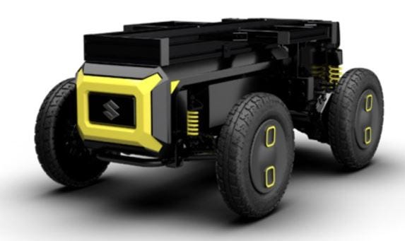
By combining autonomous driving, AI, and other partner technologies with this mobility platform, the initiative aims to address challenges in various fields, such as logistics, snow removal, civil engineering and construction, and measurement and monitoring, the company said. The concept will leverage the Soracom IoT platform as well as a communication module to enable real-time cloud connectivity for vehicle operation status updates and GPS-based location tracking, the company said.
Contact: Justine Schneider, for Soracom, (404) 266-2060, ext. 507, jschneider@calysto.com, www.soracom.io.

Create a FREE ManyMe Account.
Pointr AI Maps Now Integrated in Dubai Malls
Pointr has announced that the Dubai Mall and Dubai Hills Mall have integrated the company’s AI maps. The shopping center’s app deliver navigation and enhanced visitor’s experience, the company said.

The Dubai Mall, with millions of visitors each month, has thousands of stores. The Point-based app allows visits to receive real-time wayfinding for navigating the massive space, the company said.
Contact: Pointr, www.pointr.tech.com..
Suntech Rolls Out ST434R GPS Tracker
Suntech International USA has launched its ST4345R GPS device tailored for external environments, the company said. This device excels in remote data transmission, ideal for scenarios demanding resilient, weatherproof equipment.

Equipped with digital inputs, an RS232 serial port, and versatile output capabilities, the ST4345R seamlessly integrates with various sensors, the company said. In addition, the tracker operation on the LTE-Cat M1 and NB2-IoT.
Contact: Suntech International USA, info@suntechus.com, https://lnkd.in/ert_mnec.
Netmore and Zenze Partner to Deploy LoRaWAN Networks for Cargo and Asset Monitoring at Ports and Terminals Worldwide
Netmore Group has partnered with Zenze to offer low-cost wireless infrastructure for tracking and cargo monitoring applications at ports, terminals, distribution centers and warehouses. Powered by Netmore’s managed IoT network infrastructure, Zenze offers both custom-built, and local LoRaWAN networks together with data services for the tracking of refrigerated cargo, dry cargo, and other container- and asset-types, the company said. The companies initially will be focused on deploying LoRaWAN networks in collaboration with ports and terminals participating in the Cargo Visibility Network.
Contact: Ken Lynch, Netmore Group, (617) 877-5393, ken.lynch@netmoregroup.com, www.netmoregroup.com.

Click HERE to Join our growing Location Business News LinkedIn Group!
u-blox Transfers Cellular IoT Business to Trasna
Thalwil, Switzerland-based u-blox has transferred its cellular IoT module business to semiconductor company Trasna. The Swiss GNSS module company, which transferred its cellular module technology (plus employees, sites and product portfolio), first announced in January that it was phasing out the cell unit to concentrate on its location business.
(see paid subscriber analysis below, plus Apple is using companies to update Maps, Jobs/People).
Keep reading with a 7-day free trial
Subscribe to Location Business News to keep reading this post and get 7 days of free access to the full post archives.